All Activity
- Past hour
-
 The HRRR ydy suggested stuff would linger/redevelop after midnight today, but it was right along the S Coast. It's more N, and look in CT and far SW MA. You have these li'l cells developing, moving SE, while high level anvil pcpn areas are moving E! "Pseudo-PRE" event for CT last 12 hr for the big rains coming??
-
 O.NEW.KBOX.FA.A.0002.260706T0600Z-260707T1800Z/ /00000.0.ER.000000T0000Z.000000T0000Z.000000T0000Z.OO/ Hartford CT-Tolland CT-Windham CT- Including the cities of Windsor Locks, Vernon, Hartford, Willimantic, Union, and Putnam 224 AM EDT Sun Jul 5 2026 ...FLOOD WATCH IN EFFECT FROM LATE TONIGHT THROUGH TUESDAY AFTERNOON... * WHAT...Flash flooding caused by excessive rainfall is possible. * WHERE...Northern Connecticut. * WHEN...From late tonight through Tuesday afternoon.
 -
Crushed

- Today
-
I'd like massive drone displays then about ten million dollars' worth of fireworks. I NEVER, EVER GET ENOUGH FIREWORKS. I'd forego a 20 foot Sierra Blizzard for a week of intense fireworks.
-
I watched them online. Now I get to watch the fireworks over and over and over again. I'll be pretty exhausted in a few more hours......
-
.thumb.jpg.6a4895b2a43f87359e4e7d04a6fa0d14.jpg)
Central PA Summer 2026 Discussion/Obs Thread
Yardstickgozinya replied to Voyager's topic in Upstate New York/Pennsylvania
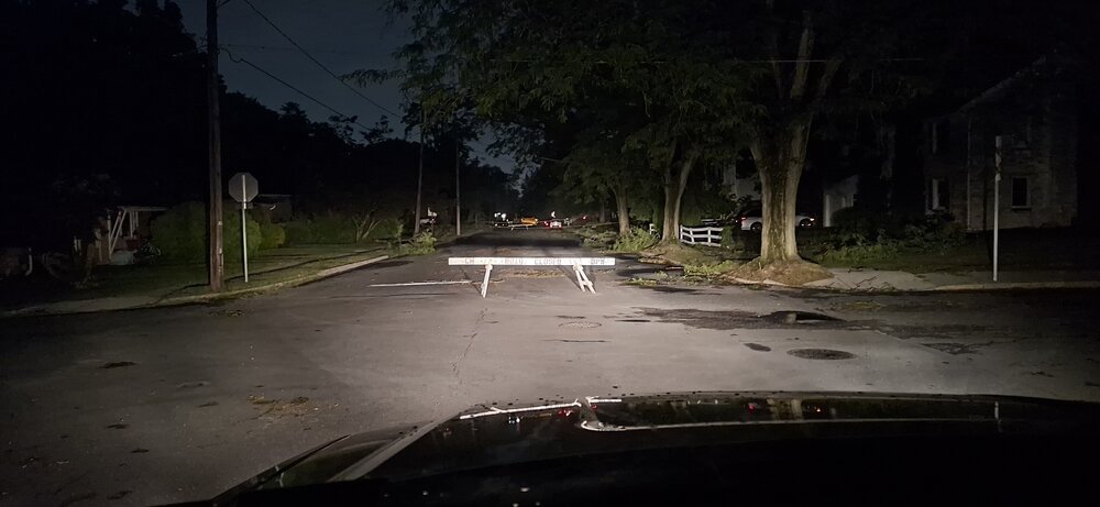
@Jns2183 1:43AM I'm driving through Camp Hill right now checking out all the damage throughout your town. This is locally historic, without a doubt. There's at least 6 trees down on my property. I'm going to take a walk in the woods tonight and assess. Heading out the Carlisle pike, next then driving back through Mechanicsburg, and checking out some of the areas where where I posted some of my first pictures from today.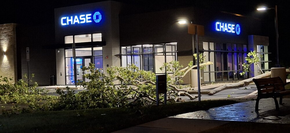
-
Thank god this heatwave is over. This was incredibly intolerable.
-
.thumb.gif.f92b16c631a1d15d405ed77b33f0710d.gif) It's that time of year....a few areas will get CROAKED with FF while a few miles away? wha? "nbd" Love it!!
It's that time of year....a few areas will get CROAKED with FF while a few miles away? wha? "nbd" Love it!! -
Only 0.18" here tonight. Better than nothing but I hope we have better luck tomorrow. HRRR did a good job with the timing of tonight's rain, and I see the 0z run is showing a repeat tomorrow with our area getting hit around 10pm. I'm hoping to have better luck with heavy rain tomorrow night. If not I know it looks like a pretty good soaking on Monday. I am desperate for a good amount of rain -- hopefully this dry stretch is about to end.
-
Yes, a 48 hr event will lessen overall impact. 6" of rain in 6 hr is not the same as 6" in 48 hr, at least not for flash flooding. For larger-scale river flooding, this is not the case. However antecedent conditions being so dry and water levels low, this should mitigate large-scale river flooding. Not that there will be none, but "it could be much worse!" Cliche I know, but sometimes it does fit a scenario well when trying to quantify impact. I always go back to VT w/ Floyd from 1999 and Irene from 2011. Similar big rains in VT from both, but Floyd flooding was not big time, but Irene was. Why?, antecedent conditions. Summer of 1999 was one of the driest on record for NNE, and summer of 2011 one of the wettest. Or going way back, Connie and Diane 1-2 punch in a week Aug 1955. Connie "primed" things, and Diane sealed it. Worst flooding in SNE on record I think.
-

Big Heat (and storms?) Week into July 4th Weekend
Silver Meteor replied to yoda's topic in Mid Atlantic
Thought you were joking until I looked it up ...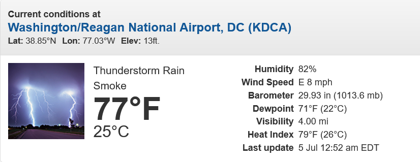
-
 Hope I’m wrong but I’m getting some shades of August 2024 around this area with those rainfall totals, where the Naugatuck valley area got decimated with 10+ inches rain. As for tonight, I had to drive from Shelton to Beacon Falls right in the middle of it. Rain was insane and lots of cloud to cloud lighting but I think we missed the winds. Clearly some places didn’t though, lots of outages in CT all things considered.
 -
Anywhere near the May 15, 2018 level? How would you rate?
-
current conditions at DCA - Rain, Smoke
-
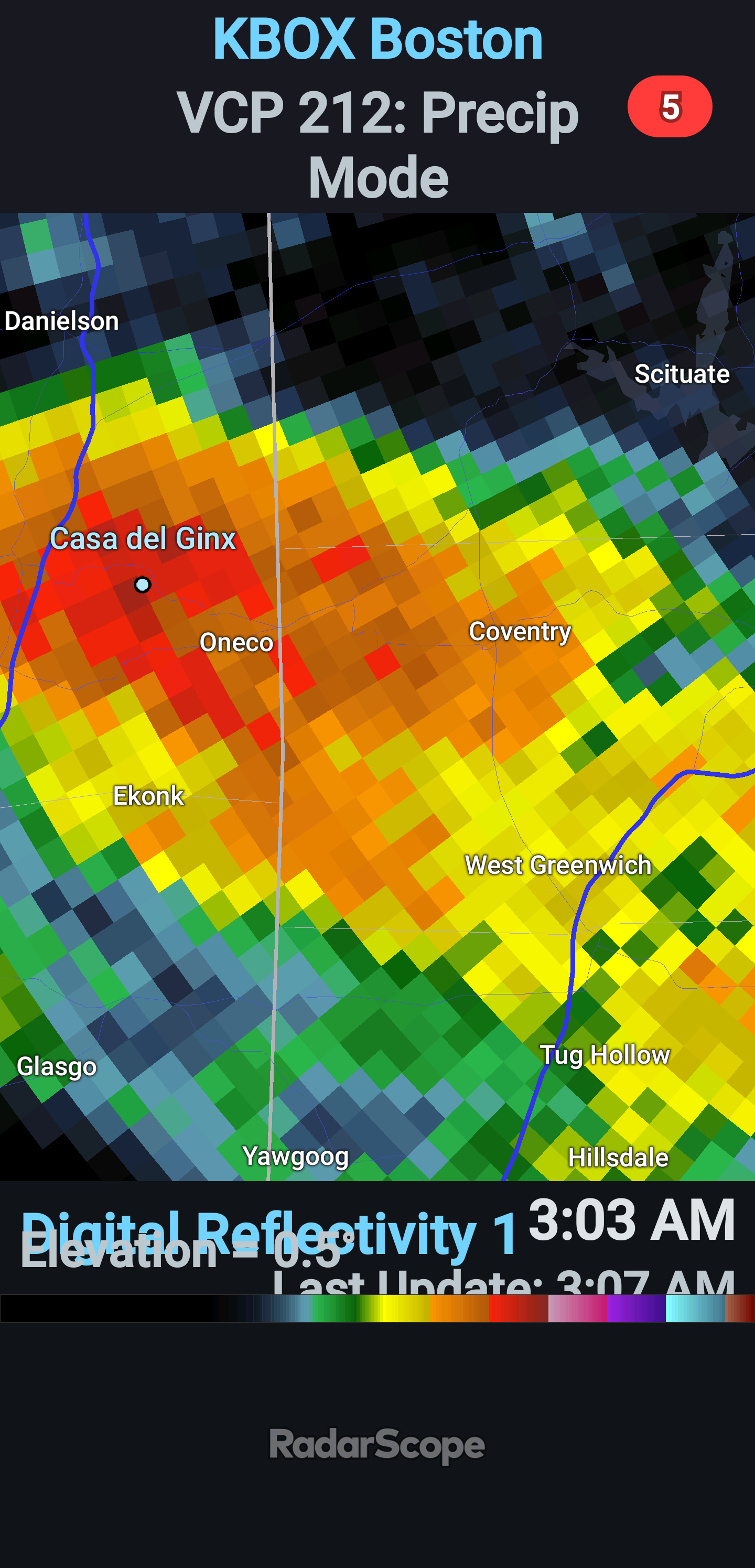
Sharp reflectivity gradient on the leading edge --classic sign of strong straight-line winds!

-
Yes most likely, and topography often helps w/ the lift, makes the inflow part condense closer to the ground. Wx tidbit: SCUD stands for "scattered clouds under deck." I think there is a slightly different definition as well (one word different). I know some here already knew this acronym, but many mets I have talked to over time had no idea it was an acronym!
-
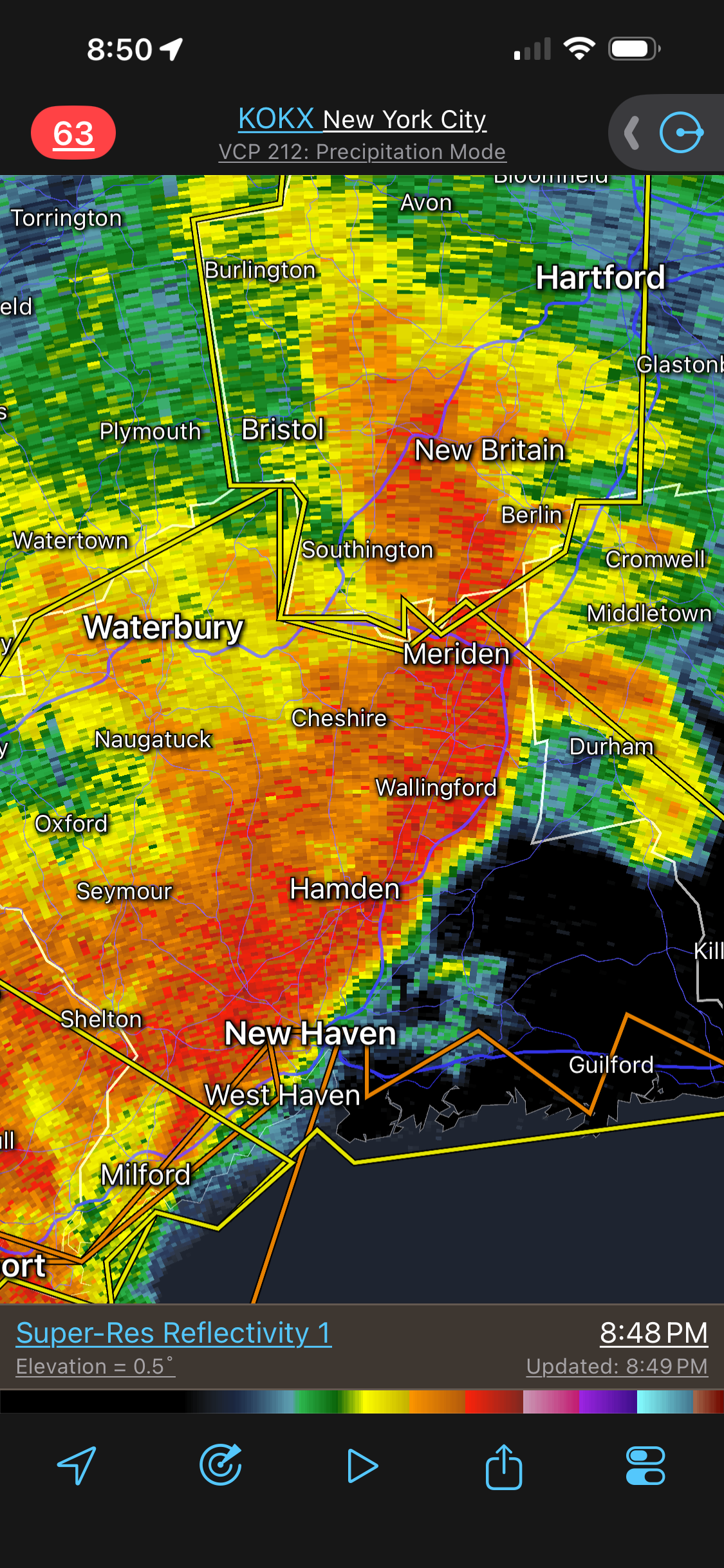
Hamden CT, more specifically!
-
This falls along the lines of how TCs are treated N of 35N. You can't apply conventional TC rules at higher latitudes due to ET transition and a host of other factors. I think this was w/ Earl in 2010. All models had the hurricane passing E Cape Cod w/ its recurvature. Yet they had TS warning as far W as BDR? That is ridiculous. That explicitly says TS sustained (not gusts) are forecast. How are you going to do that w/ a system that passes E of Cape Cod? TCs are no longer symmetrical at this latitude due to ET transition, and due to forward acceleration, the winds are greatly mitigated W of the center track. It's not "one size fits all" for wx events and all locations, but that's the impression I get at times.
-
That constant rumble from downtown was wild!
-
After the rain we were socked in fog in Chicago. I think the city did its fireworks show but you couldn't see it and could barely hear it. Sad/ridiculous. Should've been postponed.
-

E PA/NJ/DE Summer 2026 Obs/Discussion
LVLion77 replied to PhiEaglesfan712's topic in Philadelphia Region
I welcome a flooding rainfall event. Maybe not 5” but would like to see 3” this week.We need it in so many ways. -
Big Heat (and storms?) Week into July 4th Weekend
Silver Meteor replied to yoda's topic in Mid Atlantic
Anyone else watching the July 5th fireworks in DC? Going to be a lot of exhausted people tonight. -

2026-2027 Super El Nino
GaWx replied to Stormchaserchuck1's topic in Weather Forecasting and Discussion
On July 4th, the DMI mean Arctic temp finally reached and exceeded 0C with it at +.01C. That sets a new record latest 1st above freezing as it replaces the old record latest of June 20th, which had been set in 2013. -
Hope it comes back soon. This does remind me of the 2012 derecho in that it doesn’t feel like the power companies region-wide were adequately prepared for this. Could be the holiday or just complacency from lack of high-impact weather lately. I do remember back then everyone was so angry and then it did lead to better prep for Sandy later that year.
-

2026 Mid-Atlantic Severe Storm General Discussion
high risk replied to Kmlwx's topic in Mid Atlantic
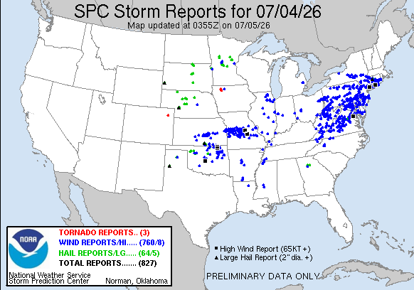
Impressive number of reports today in the Mid-Atlantic, but a noticeable hole over northern Virginia.