All Activity
- Past hour
-
Imagine if this was a snow event.
-
This is likely the storm that spawned the damage. This view is reportedly from about 15 miles south of the damage area and the storm was moving north. https://www.facebook.com/share/v/1Fb2YSrvcB/
-
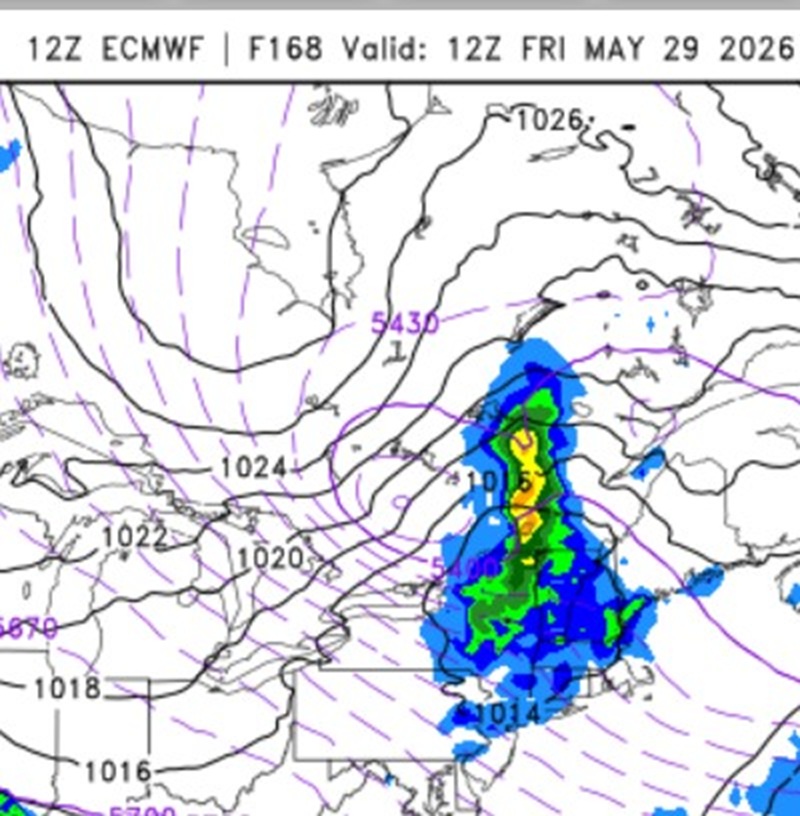
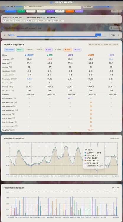
Accumulating snow in June outside of MWN or AOA 5000 ft is very rare in New England. Look at the 168 hr 12z ECMWF. Nice cold cut-off at 500 dropping SSE. That how you do it this late. The most Xtreme 500 case was May 9-10, 1977. You could track the upper low from northern Hudson's Bay all the way to S of LI, where it became a massive 5 contour 500 cut off (going by every 6 dm). Of course, it would take an truly extraordinary set up for Scott to see flakes in June here! The June 6, 1816 S+ in NNE had the benefit of the volcanic cooling combined w/ a strong sun Maunder minimum.

-
18z in general seemed pretty wet to me, looks like 2”+ for most especially I-80 and S on the RGEM, NAM. In any event looks like a nasty 48hr period upcoming.
-
Damage from a storm this evening just east of here. Fellow that shared the photos said it was a tornado but I'd guess it was a downburst.
-
Light rain all day and now pouring here again. I'm well over 3" for this event now. I may have to start measuring every 6 hours to avoid rain compaction.
-
Haha, I'm back in CT now but life has definitely returned up there. SLK was a ghost town in March and April lol. Now there are boats on the water, hikers on the trails, and restaurants reopening.
-
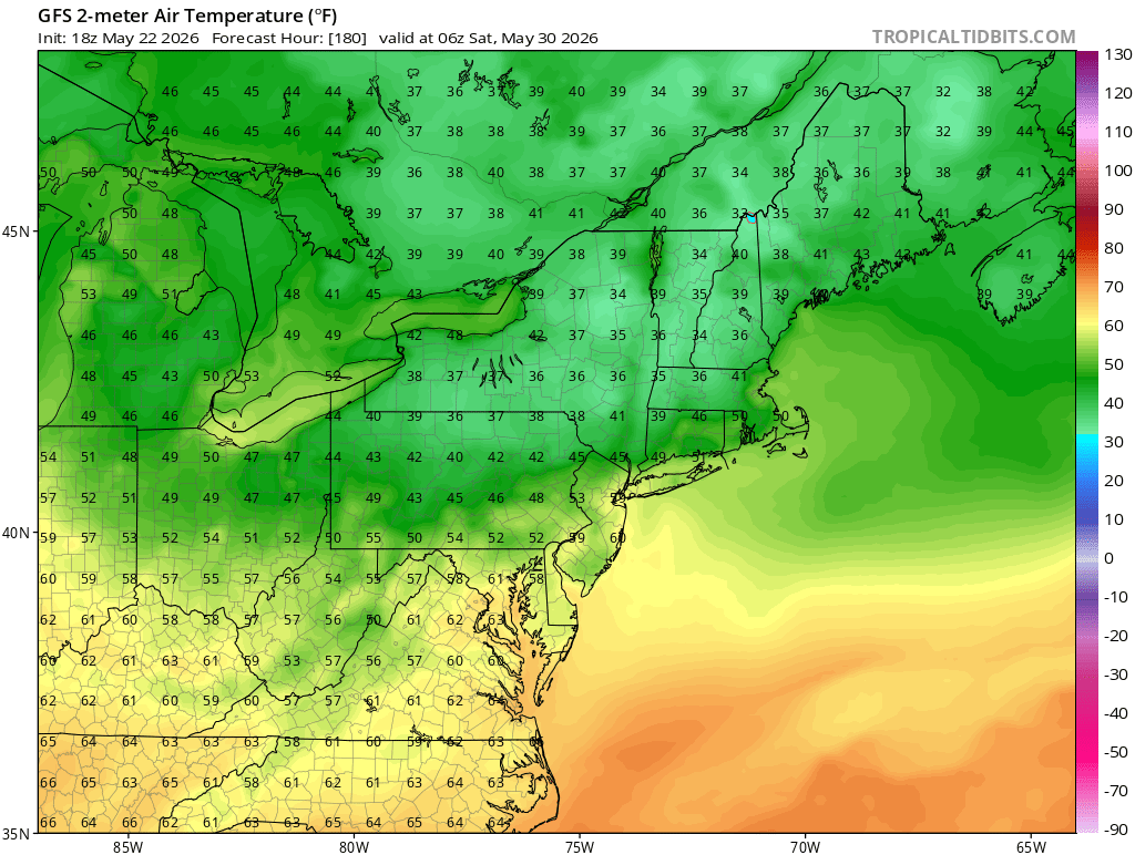
You think 1,000ft where his point and click is probably from sees 10 days of 75-85? I’m guessing 1,000ft is 67-79F starting Monday like that forecast. Doesn't seem unreasonable.
-
A beautiful rainy evening.
-
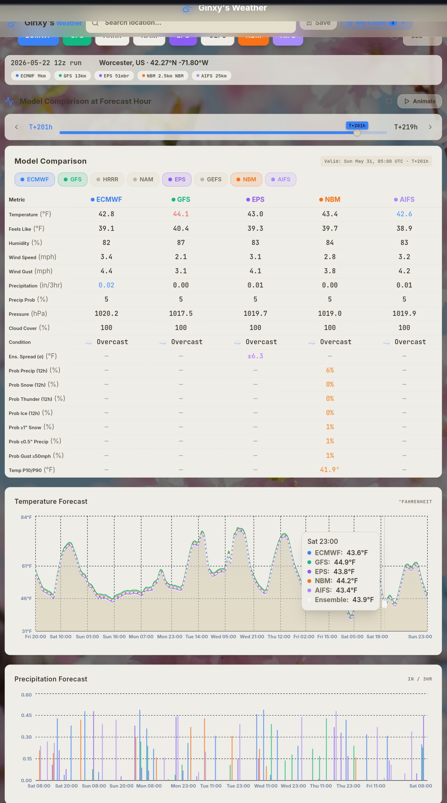
Super Ensemble Modeling Ginxweather.com
- Today
-
2.13” last 2 days.
-

2026-2027 Strong/Super El Nino
raindancewx replied to Stormchaserchuck1's topic in Weather Forecasting and Discussion
No PDO flip this year. If you call 1957/1958 spiking positive in the -PDO cycle prior as the same point as 2014/2015, we're around 1968 now. We're within a decade, as it's not exact, but I'd bet the PDO doesn't average positive for Nov-Apr. We're probably in something like 1965-66 El Nino strength at 1968 timing cyclically, which was a big El Nino about a decade from the +PDO flip. I'd expect continuing regression toward 0 and a month or two may poke above it, but Nov-Apr won't be over 0. AMO on the other hand...might be this year. Atlantic in May is night and day different to 2023. The colder water by NZ v. 2023 also bodes well for more typical El Nino conditions in the West. Cold/Colder AMO is a decent wet signal and cold signal in winter for a lot of the US. -
32.2 at WXW2 this morning, but man did it turn beautiful.
-

2026 Spring/Summer Mountain Thread
Maggie Valley Steve replied to Buckethead's topic in Southeastern States
Moderate rain with thunder. I'd like you folks input on starting our own SE Region Tropical thread. I know how much trauma Helene brought to our Mountain neighbors. My primary weather focus has always been tropical going up along the Upper Texas Coast. The SE Region covers a tremendous amount of Coastline from Mississippi to the Outer Banks. El Ninos tend to throw a curveball or two not far offshore. If you think the SE posters would participate, let me know. -
So far for this event/Columbia: 1.74” 5/20 - 5/21 — 1.17” 5/22 -- 0.57” with ongoing light rain … bringing May total so far to an “almost respectable — compared to recent months” — 2.90”
-
The last run had rain . Good luck using the op
-
.77 over the 2 day period
-
And it happened AGAIN It's actually funny at this point.
- Yesterday
-
frosty next weekend?

-
Just hit 2" for the event
-
Was supposed to rain today. Sprinkles that's it. At least it's 60 degrees today.
-
That’s a really bad forecast compared to modeling . Really bad
-
we take and take again!! Tonight Mostly cloudy, with a low around 43. Light and variable wind. Saturday Cloudy, with a high near 61. Southeast wind 3 to 8 mph. Saturday Night A chance of rain after 3am. Cloudy, with a low around 42. Southeast wind 3 to 6 mph. Chance of precipitation is 30%. New precipitation amounts of less than a tenth of an inch possible. Sunday Rain. High near 48. East wind 8 to 11 mph, with gusts as high as 24 mph. Chance of precipitation is 100%. New precipitation amounts between a half and three quarters of an inch possible. Sunday Night Rain before 9pm, then showers, mainly between 9pm and 2am. Low around 48. East wind 5 to 9 mph becoming calm in the evening. Chance of precipitation is 80%. Memorial Day A chance of showers, mainly before 2pm. Mostly cloudy, with a high near 71. Calm wind becoming northwest around 5 mph in the afternoon. Chance of precipitation is 50%. Monday Night Mostly cloudy, with a low around 51. Calm wind. Tuesday Mostly sunny, with a high near 79. Calm wind becoming west 5 to 7 mph in the afternoon. Tuesday Night Partly cloudy, with a low around 53. West wind 3 to 5 mph. Wednesday A chance of showers after 5pm. Mostly sunny, with a high near 77. Northwest wind 5 to 10 mph, with gusts as high as 20 mph. Chance of precipitation is 30%. Wednesday Night Mostly clear, with a low around 50. Northwest wind 3 to 6 mph. Thursday Mostly sunny, with a high near 69. North wind 5 to 9 mph. Thursday Night Partly cloudy, with a low around 47. North wind around 5 mph becoming calm in the evening. Friday Mostly sunny, with a high near 65. North wind 3 to 8 mph.
-
Not bad today with a little over half inch here.