All Activity
- Past hour
-

Is we back? February discussion thread
40/70 Benchmark replied to mahk_webstah's topic in New England
He'll start slowly...maybe take a night shift. -
Is we back? February discussion thread
40/70 Benchmark replied to mahk_webstah's topic in New England
I spent a lot of time shaved in the corps, but it's ultimately just not for me. -

Central PA Winter 25/26 Discussion and Obs
pasnownut replied to MAG5035's topic in Upstate New York/Pennsylvania
Is it over..... You callin it ?? hehe -

Is we back? February discussion thread
Damage In Tolland replied to mahk_webstah's topic in New England
Working with Vortex95?? -
Central PA Winter 25/26 Discussion and Obs
pasnownut replied to MAG5035's topic in Upstate New York/Pennsylvania
not sure we have a true split flow regime setting up in long term. More like a zonal (which at time can have NS/SS playing together (time dependent). But to answer your question, with a split flow, Its all about the boundary and what side you're on w/ respective vort pass. Longer lead zonal sorta fits tellies and upper air IMO. Remember that there are other signals, MJO/SSW that have lag time effects on long lead models, so one has to keep that in mind when seeing a model output and high fivin...or kickin stones. That said, next week may look notably different at this time. Thats all I'm sayin. We have another week of winter until we get our annual thaw, and in truth, we've had a great run despite the NS overwhelming the east, and pushing that precious boundary too far south and given NMA/Carolinas our precious snow. A true snow hound knows you gotta be close to the rain for the best snows, and thats been way far south. Bring a zonal pattern, and keep SS vorts from diggin too much (cutters) and just need to be close enough to the cold for some more chances at precip of the hopefully frozen variety. Of course if that happens, we'll likely be on warm side for some. it's how things roll. Just hope for the follow up waves to be further south. -
12z GFS...

-
12z CMC solid for southern Va
-
Nice man isn't this awesome. We wanted it for 3 winters.
-

February 2026 Medium/ Long Range Discussion: Buckle Up!
BristowWx replied to Weather Will's topic in Mid Atlantic
yeah. But its pushing near 50F on the 2m map. on the 11th. just a point of interest. for a headline like that you would think sub 500dM thickness is in the offing. its 552. long way off. who knows. -
Yes it was either 6 by 2 or 4 by4 he went 4 by. God willing he never goes back
-
Not happy that the cloud cover disappeared completely. But oh well. It's been either absolutely clear or cloudy. Never in between. lol Be nice to be mostly cloudy on these warm days. Meh.
-

WxUSAF's weak ass frontal passage thing.
SnowenOutThere replied to dailylurker's topic in Mid Atlantic
I think I'll hit 50 pretty easily. Might be time to try to break my bike out of the glacier. -
I love bald dude lol Come to GTG
-
That's does it... Man..don't send pictures of what you look like... Now I can't take anything you say seriously... ( JK ). Bald is beautiful!!! Own it!!
-

WxUSAF's weak ass frontal passage thing.
NorthArlington101 replied to dailylurker's topic in Mid Atlantic
I'm at 40 in D.C., lol. You'd think we could push 50 today -

February 2026 Medium/ Long Range Discussion: Buckle Up!
JenkinsJinkies replied to Weather Will's topic in Mid Atlantic
That top map is wind chill. -

E PA/NJ/DE Winter 2025-26 Obs/Discussion
mattinpa replied to LVblizzard's topic in Philadelphia Region
It usually takes me until April to be ready for spring due to how short the season is (December is usually when we get our first true winter weather) and my appetite for snow. If we cash in during the upcoming period, I would be more ready early. I like the fact we got a good winter - have had enough mild ones lately that some I talk to seem to forget what it’s like. -

Occasional Thoughts on Climate Change
TheClimateChanger replied to donsutherland1's topic in Climate Change
UAH TLT data was released this morning. Globally, the anomaly came in at 0.35C, up 0.05C from December. For the CONUS, January 2026 averaged 0.30C above the 1991-2020 mean. The CONUS winter season to date (December & January) is currently the warmest on record (since 1978-79) in the satellite-based dataset, and by a very significant margin over No. 2. The two month average is +1.20C for the CONUS, while the prior record for December & January was set in 2021-22 at +0.91C. Very likely that this will be the warmest winter on record in the CONUS in the UAH TLT data. -
Is we back? February discussion thread
40/70 Benchmark replied to mahk_webstah's topic in New England
I think for reserves it's two, that's probably what it is. -
WxUSAF's weak ass frontal passage thing.
SnowenOutThere replied to dailylurker's topic in Mid Atlantic
Currently has me more than 5 degrees cooler than it is outside. -
The hires RGEM killed it on the last two storms. Especially the one two weekends ago, but here's a run from Friday that did fairly well as well
.thumb.png.859d9a8d0189e41e652f742df629a988.png)
-
February 2026 Medium/ Long Range Discussion: Buckle Up!
BristowWx replied to Weather Will's topic in Mid Atlantic
OP GFS doesn't look cold at all during that time. Does it or am I hallucinating? -
Yesterday morning I got 14-15”. Some less in sun, some yards have more. That’s about avg. I saw 16.5 in S Wey and 18” in Kingston all yesterday. I’m sure if I had a wooded lot it would be more.
-
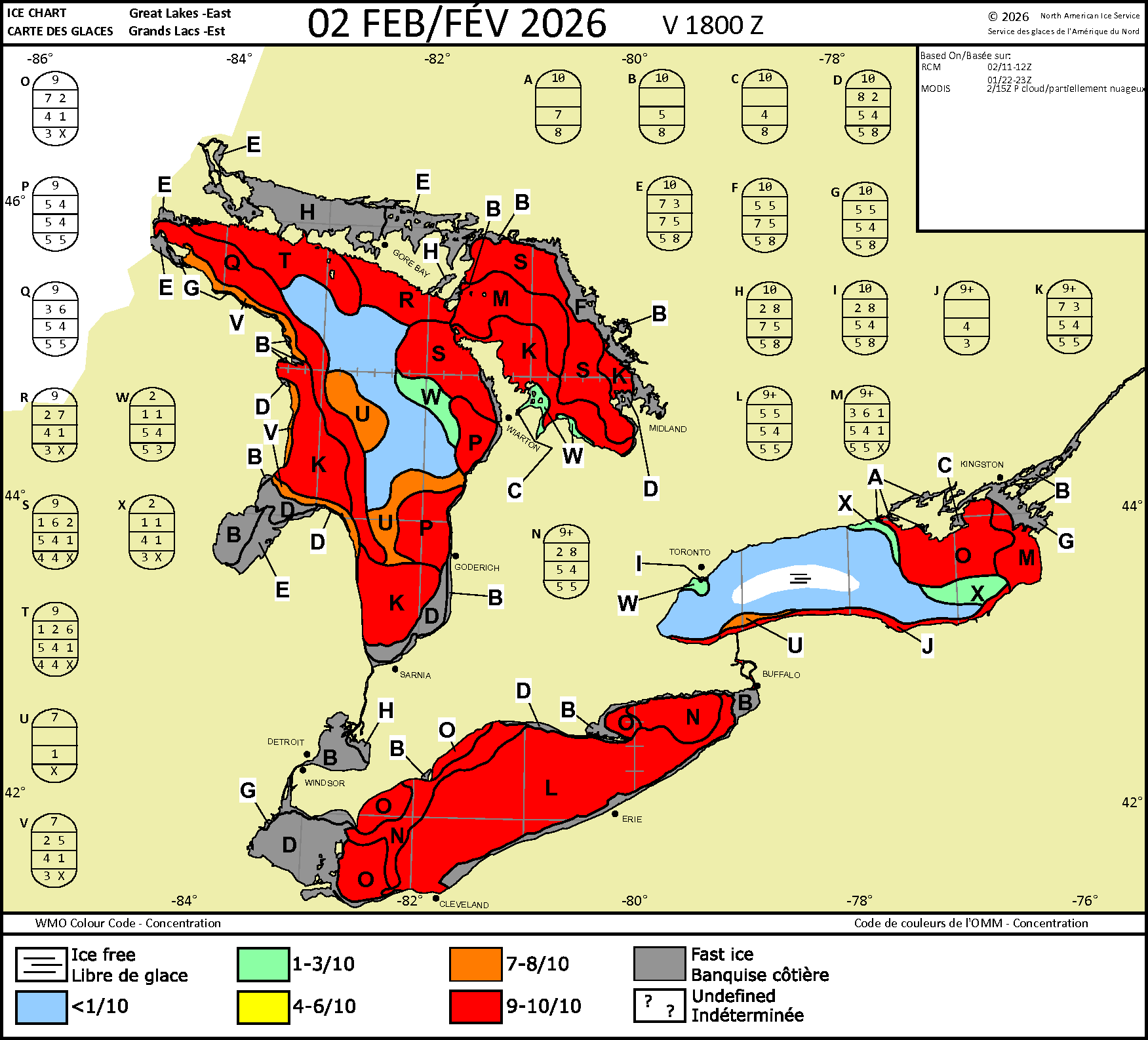
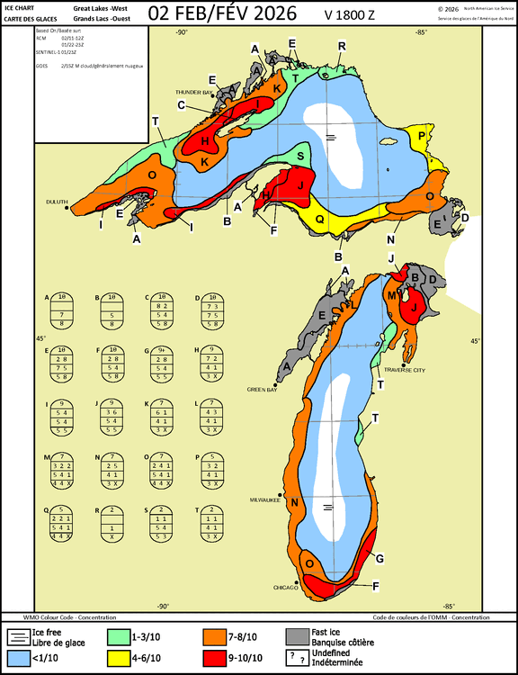
Ice conditions as of Feb 2. Pretty much a variety of ice thickness now. Here's the egg code interpretation page. Stage of development has one for sea ice, and one for lake ice. So make sure your looking at the right one. (Lake Ice) https://www.canada.ca/en/environment-climate-change/services/ice-forecasts-observations/publications/interpreting-charts/chapter-1.html

-
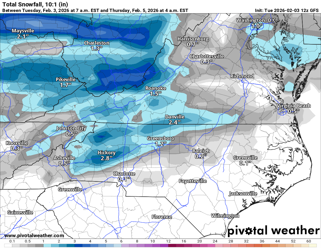
If we play our cards right we might all manage to get to 0.5" this week!


.png.684068ebc1e4a5c1e998d905bf54404f.png)