All Activity
- Past hour
-

Central PA Autumn 2026
Mount Joy Snowman replied to canderson's topic in Upstate New York/Pennsylvania
Low of 45. Heading up to Happy Valley this afternoon! -
Low of 42 in Marysville. Agreed, lower than what I expected.
-
-
Through history, the opposite has occurred vs intensifying. The recent ones to intensify had much weaker shear vs what is forecasted.
-
As a Alabama native, this storm is emulating Opal more than anything else. I wouldn't be surprised if this makes landfall as a category 3 even though the environmental conditions are yielding weakening. Also the fact that college football games are scheduled to be held in outdoor open air stadiums uninterrupted is idiotic. The wind gusts are going to make doing most pass plays impossible to do successfully along with the fields becoming slush/mud pits during the games. These are impending disasters waiting to happen. Yes, the tornado and damaging winds are looking to be the biggest threats to AL to SC.
-
But also plenty of situations like Opal 1995, Lili 2002 and Dennis 2005 where the storm collapsed coming in. It could be a high end Cat 1 or even cat 2 at landfall though since it only has so much time to weaken before landfall. Thankfully for surge it’s a smaller sized storm so it can’t build up a huge mound of water. Definitely a tough forecast but hopefully people down there prepped for a stronger than expected storm.
-
I drafted Jayden Daniels as my fantasy QB, and I just grabbed Michael Penix on the waiver wire. So do I start the guy who has consistently disappointed in fantasy when he hasn’t been hurt or the guy playing against my favorite team?
-
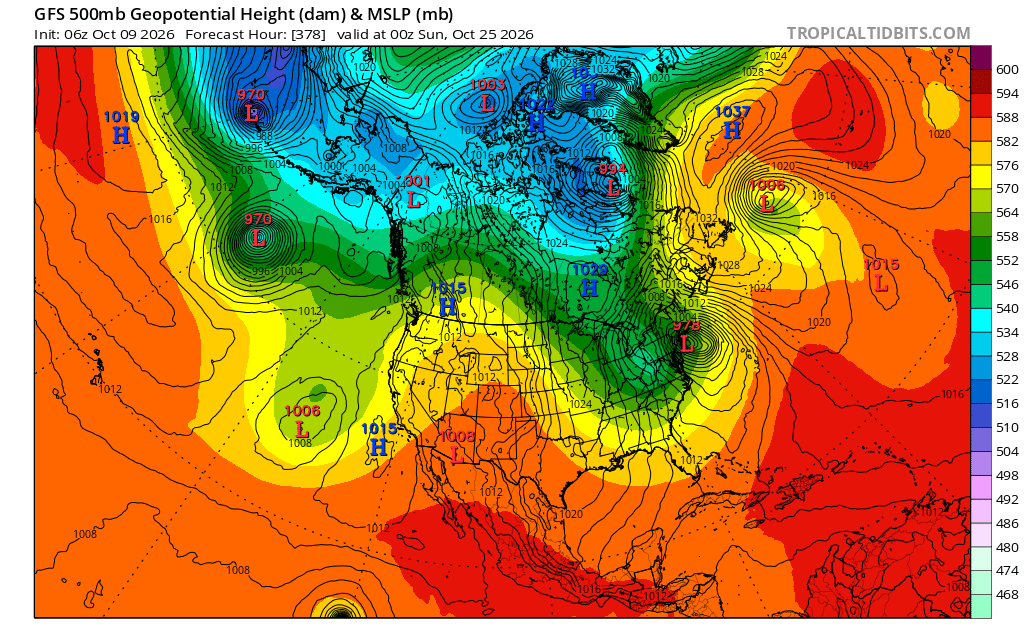
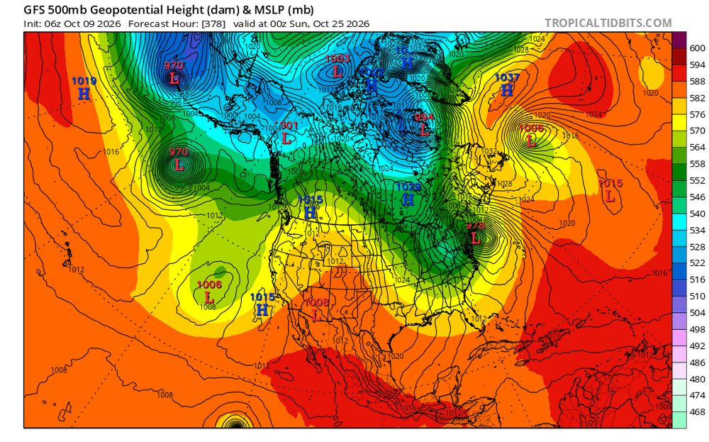
GFS hour 384. Let's do this:
-
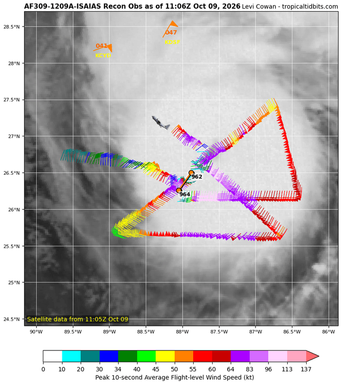
We wish we were in Florida.. storm still intensifying quickly
-
 legitimate mexican pharmacy online: SierraMeds Rx - mexican farmacia
 -
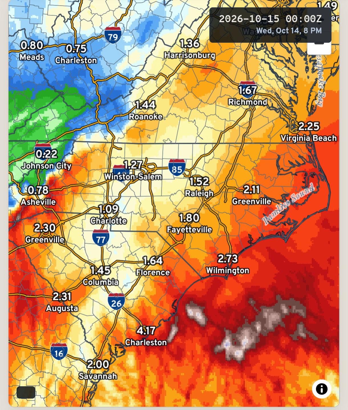
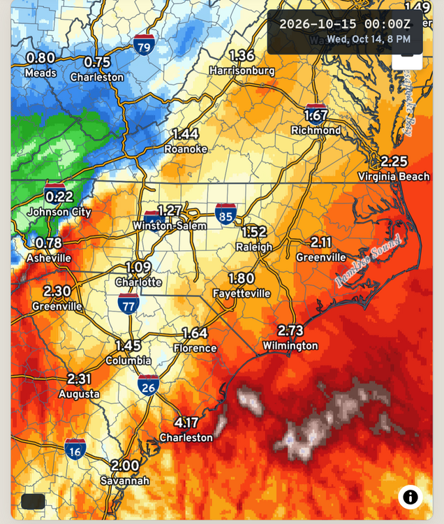
Good thing I have well water... can we get rain on any other day than Sunday though?
-
The latest blend of models. Still looking promising
-
we seen this scenario so many times in the gulf a storm suppose to weaken due to sheer actually get stronger right until landfall..
-
Also we've seen how storms can maintain higher gusts as they weaken for a time. Plus with the broadening of the wind field inland gusts to 50mph+ will be quite widespread, which is impactful with all the trees
-
Agree with you, NHC even has this verbiage in the 4AM discussion…. Isaias will likely become a major hurricane soon with the improving satellite imagery, and it could continue to intensify for the next 12 hours or so while it moves over very warm and deep water. However, a large increase in shear is anticipated before landfall, which will probably cause some weakening to occur. This is a tenuous spot because it would only take about a 6h delay in the onset of the shear to bring a stronger hurricane than expected onshore. .
-

2026-2027 Record-breaking El Nino
bluewave replied to Stormchaserchuck1's topic in Weather Forecasting and Discussion
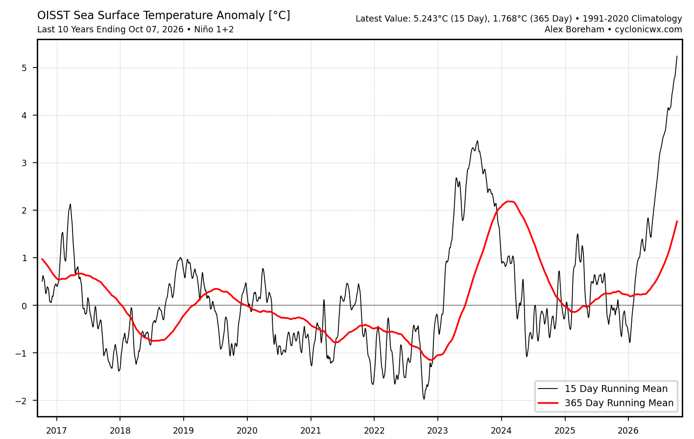
It feels like we have started to see non-linear shifts following these major heat releases to the atmosphere from the accumulated excess heat stored in the oceans. If you think about it we had a very similar climate from the late 1800s through about 1982. Sure there was some warming from 1885 to 1982, but nothing all that dramatic. Since the coldest winters of that era occurred in the late 1970s. Then the 1982-1983 super El Niño gave a slight bump to temperatures which remained about steady until 1997-1998. Following the 1997-1998 heat release, the greatest warming occurred in the Arctic several years later from 2005 to 2012. So the state of the Arctic sea ice shifted to much younger around 2007 and continues to this day in the same range. Then the next major heat release in 2015-2016 dramatically warmed our winters to the point that places like NYC only saw their next long term colder winter after 2014-2015 a full 11 years later in 2025-2026. The major climatic shift following 2015-2016 was the rapid warming and ridge expansion east of Japan beginning around 2018-2019 which has lead to this persistent record -PDO run. The heat release in 2023-2024 lead to the warmest CONUS winter to that point. 2025-2026 finished close to the warmest also but our little corner of the world finally got a cold winter after 11 years. But the geographic footprint relative to the rest of the CONUS was very small. It didn’t take away from the fact that it was an enjoyable winter for many here. Nino 1+2 never fully cooled off following 2023-2024 and gave us the Nino-like December 2024 with the record +PNA for a La Niña. Now this is the first time 2 El Niños this strong have occurred only 3 years apart. It feels like the big shift following 2023-2024 was a warming of the EPAC which had been the one region of the planet that had resisted the warming through 2022-2023. Many papers were written about the famous EPAC cold tongue. Now this current warming there has exceeded anything that has occurred in the past. This event into 2027 is going to be the greatest heat release to a higher baseline than all the previous events. So we don’t fully understand the shifts that will occur following this jump to a much warmer climate as we head into the late 2020s and then early 2030s. This EPAC warming since 2023-2024 in the chart below has been unprecedented.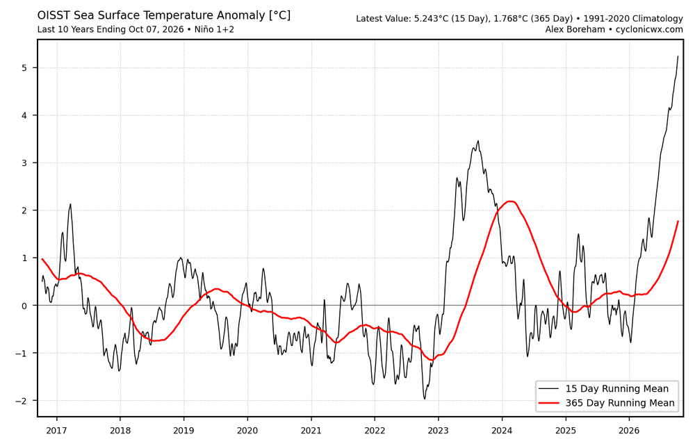
-
What a tough forecast. You have an intensifying likely major hurricane on final approach and are banking on a decapitation to occur in next 12 hours while the system is still intensifying at the moment. Wouldn’t want to be the one sending that messaging. NHC is doing a fantastic job with it. I still think this weakens to cat 1 by landfalll but NHC noted explicitly they are expecting a high end cat 2 when it crosses the coast now
-
37 this morning, didn't think it would get that cold overnight.
-

2026-2027 Record-breaking El Nino
PhiEaglesfan712 replied to Stormchaserchuck1's topic in Weather Forecasting and Discussion
I was originally going to Vermont in late January, but the first Nor'easter happened. I ended up going the weekend of March 7-9, and that point, the winter was just about over. I got temps in the mid-50s/lower 60s each day. I stayed in Manchester, and had to drive up to Weston on the last morning to see some frozen weather. -
-
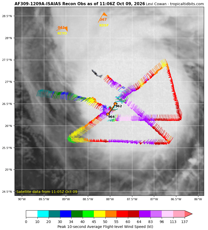
Eye coming into radar view of KEVX and KMOB now snd it looks very strong
-
https://sierramedsrx.shop/# best mexican pharmacy for prescriptions
- Today
-
Matt east just posted this on FB. Enhancement for the win around here .
-
We need it. Our reservoirs are dry.
-
Good luck. I know exactly what you are and will be going through. It's a tough road, but definitely worth it.