All Activity
- Past hour
-
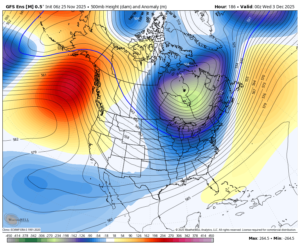
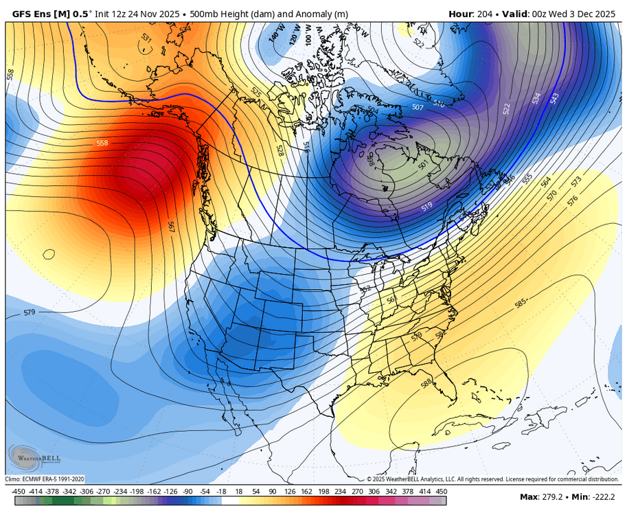
The above noted colder GEFS trend for early Dec continued with the 12Z run.
-

Nov 28-30th Post Turkey Day Wintry Potential
migratingwx replied to Chicago Storm's topic in Lakes/Ohio Valley
Canadian was cold, Euro running now.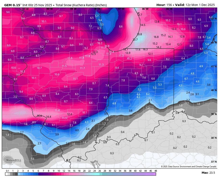
-

2025-2026 ENSO
PhiEaglesfan712 replied to 40/70 Benchmark's topic in Weather Forecasting and Discussion
December 2010 is the only one that's reasonable. At least that happened in the newer climate. (It's not a good analog, but due to other things... like near solar min and strong la nina, features we don't have this year. Maybe it could work if we have a strong la nina in place in December 2028, when we're closer to a solar min.) December 1983 is an older, colder climate. Not likely to happen unless we have a Pinatubo event. (83-84 actually would have been a very good analog for 95-96.) December 1989, well, that was a once-in-a-lifetime event. A coldest December on record, followed by an early turn to spring (and never looking back) is almost certainly never going to happen again. -

November 2025 general discussions and probable topic derailings ...
FXWX replied to Typhoon Tip's topic in New England
1000% agree... -
Agreed. Juice it up
-

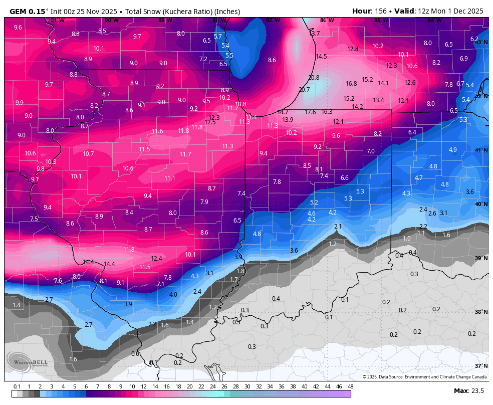
Digital Snow/Ice Thread 2025-2026
WinstonSalemArlington replied to WinstonSalemArlington's topic in Southeastern States
Ya know, this wasn’t far off to northeast North Carolina considering -

Nov 28-30th Post Turkey Day Wintry Potential
sbnwx85 replied to Chicago Storm's topic in Lakes/Ohio Valley
UKIE stayed south FWIW. Is the Canadian delayed? -
Digital Snow/Ice Thread 2025-2026
WinstonSalemArlington replied to WinstonSalemArlington's topic in Southeastern States
December 3 -

November 2025 general discussions and probable topic derailings ...
WinterWolf replied to Typhoon Tip's topic in New England
I agree with you. Ya, just trying to get reasonable and accurate info is all. It’s tough when some folks say things are slipping away, just looking for a MET to chime in and reassure them that it’s not. That’s the BS nobody needs. -
Mid to long range discussion- 2025
WinstonSalemArlington replied to wncsnow's topic in Southeastern States
December 3 -
soon we'll get randy's pbp
-
Can’t believe it’s only a week out! Definitely our first realistic window with pattern support (and ofc the cmc is delayed)
-

Nov 28-30th Post Turkey Day Wintry Potential
Radtechwxman replied to Chicago Storm's topic in Lakes/Ohio Valley
Definitely aggressive with the waa. Curious to see 12z euro -
For the weenies out there. I got the windows wxstar 4000 simulator setup on my computer. I just need to get the playlists going. Now I won’t see a +SN ob all season. Screen Recording 2025-11-25 120356.mp4
-
yeah lots of cutters that year which led to icy conditions
-

Nov 28-30th Post Turkey Day Wintry Potential
mannynyc replied to Chicago Storm's topic in Lakes/Ohio Valley
-
Yea this is a big test of winter expectations and everyone is carrying almost a decade of scar tissue with them
-
I would say we've much less matured rather than being hurt time and time again by rug pull after rug pulls. especially last season in february
-
A well timed trailing wave with cold coming in behind the initial low is a pretty common and uncomplicated way to get some snow here. The advertised pattern is conducive.
-
Nov 28-30th Post Turkey Day Wintry Potential
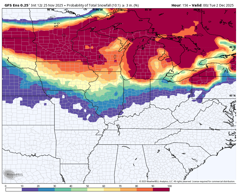
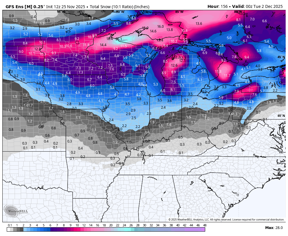
migratingwx replied to Chicago Storm's topic in Lakes/Ohio Valley
% for >3" is lower than the 6z run for Chicago.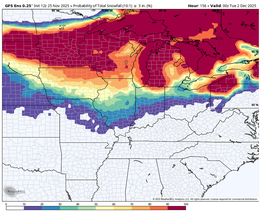

-

E PA/NJ/DE Autumn 2025 Obs/Discussion
LVblizzard replied to PhiEaglesfan712's topic in Philadelphia Region
Models are looking somewhat interesting for next week. GFS/Euro both give us a few inches of snow from a SWFE next Tuesday. -
Yeah why bother? Lol Although I don't care how far out in lala land it is...clown maps like this still make me mad just because of the mere image of the fringeline nobody can explain
-
Agreed but we have to watch the SE ridge since the PNA is going to be negative.
-
We know what happens next
-

Nov 28-30th Post Turkey Day Wintry Potential
A-L-E-K replied to Chicago Storm's topic in Lakes/Ohio Valley
def taking on a more traditional snow storm evolution, obviously slp track trending wrong way for non-wisconsin posters but still time there idk about u guys but i'm very over the strung out and sw cutoff rigmarole we've been dealing with the past few years, remember negatively tilted troughs?