All Activity
- Past hour
-
Hopefully they become big ole, slow moving gully washers with lots of lightning. Severe around here is always really isolated. I feel like the majority of it comes from random down burst during summer thunderstorms. I remember widespread straight line winds once in my nearly 50 years here. Tornados are rare unless you live in La Plata. Evidently that town has been flattened more than once.
-

Central PA Summer 2026 Discussion/Obs Thread
mahantango#1 replied to Voyager's topic in Upstate New York/Pennsylvania
Seen this at the theater in Wilkes Barre when it came out, and got the dvd...well worth seeing excellent! Agnes Flood Documentary Project npreodstoSa1c648t3l61l73h53alu3ci3452f7iatum381uh21001817070 · On this date in 1972 - June 21 - torrential rains were hitting the Wyoming Valley. "Agnes" was here. Two days later, the people of the Wyoming Valley experienced what, to this day, is simply referred to as "The Flood." It was the worst natural disaster in U.S. history. On Wednesday June 24, the story of those days, and the weeks and months that followed, will be told when "Agnes" returns to the big screen at the F.M. Kirby Center. Showtimes are 1 p.m. and 7 p.m. Tickets will be available at the box office at showtime, or can be purchased in advance by visiting www.kirbycenter.org or by calling (570) 826-1100. https://www.facebook.com/reel/963239149844407 See less -
Not to be a deb, but this doesn't look as impressive on the severe side as it did a few days ago. Definitely a chance for multiple rounds of thunderstorms today, but the overall spatial coverage and helicity seem to have backed off.
-
hit by what? i am at 1.25" MTD
-
Hope that’s not case, need something beneficial out of this. Next shot would be Friday.
-
If you're not in the stratiform rain zone which our subforum won't, we're relying on convection to produce any rain we get. If that misses or fails to materialize we get skunked.
-

E PA/NJ/DE Summer 2026 Obs/Discussion
Hurricane Agnes replied to PhiEaglesfan712's topic in Philadelphia Region
Well here's something we haven't seen much of in awhile - Stuff was starting to brown up so need the rain. I have 3.36" for the month so far. Currently overcast and 71 with dp 64. -
You’ll be soaked. Not sure how much convection will be generated here, but good synoptic rains there.
-
Maybe even not a drop?
-
NAM 3K looks pretty interesting for fokes DC and east. There's even a flood watch for the Philly area. Only thing I don't like is the solid overcast this morning.
-

2026-2027 Super El Nino
40/70 Benchmark replied to Stormchaserchuck1's topic in Weather Forecasting and Discussion
My interpretation of the JMA and CANSIPS is that they are seeing something real, but are overemphasizing it. Regardless, it does bolster my confidence in a favorable period of Modoki like forcing during the second half. That said, I would agree with Snowman, and most, that we aren't getting a Modoki set up in the seasonal mean with an El Nino this strong.....I think that is what many register it as when those seasons are used as analogs and that should not be the case. -
2026-2027 Super El Nino
40/70 Benchmark replied to Stormchaserchuck1's topic in Weather Forecasting and Discussion
BINGO. -
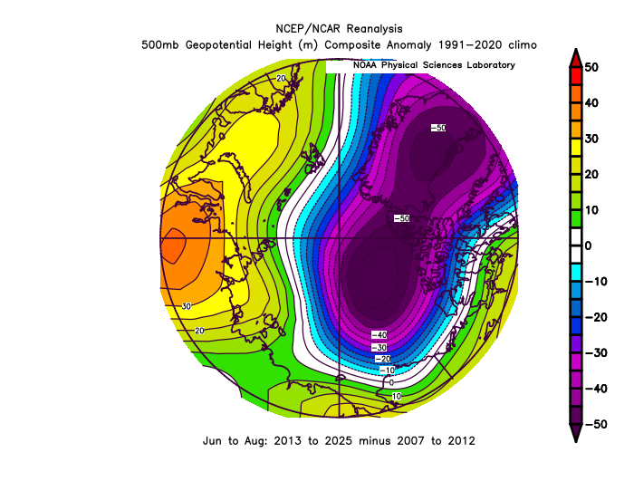
It’s a favorable pressure pattern for sea ice retention with the deep low north of Alaska. We have been seeing this weak dipole pattern much of the time since 2013. Pretty much the opposite of the strong dipole pattern which was in place from 2007-2012 which lead to the multiple records. But the post below shows that the Euro has a cold bias on the DMI chart below. Still a colder pattern but nothing as cold as the Euro shows.
-
Dandyland special on the mesos
- Today
-
lol
-

2026-2027 Super El Nino
bluewave replied to Stormchaserchuck1's topic in Weather Forecasting and Discussion
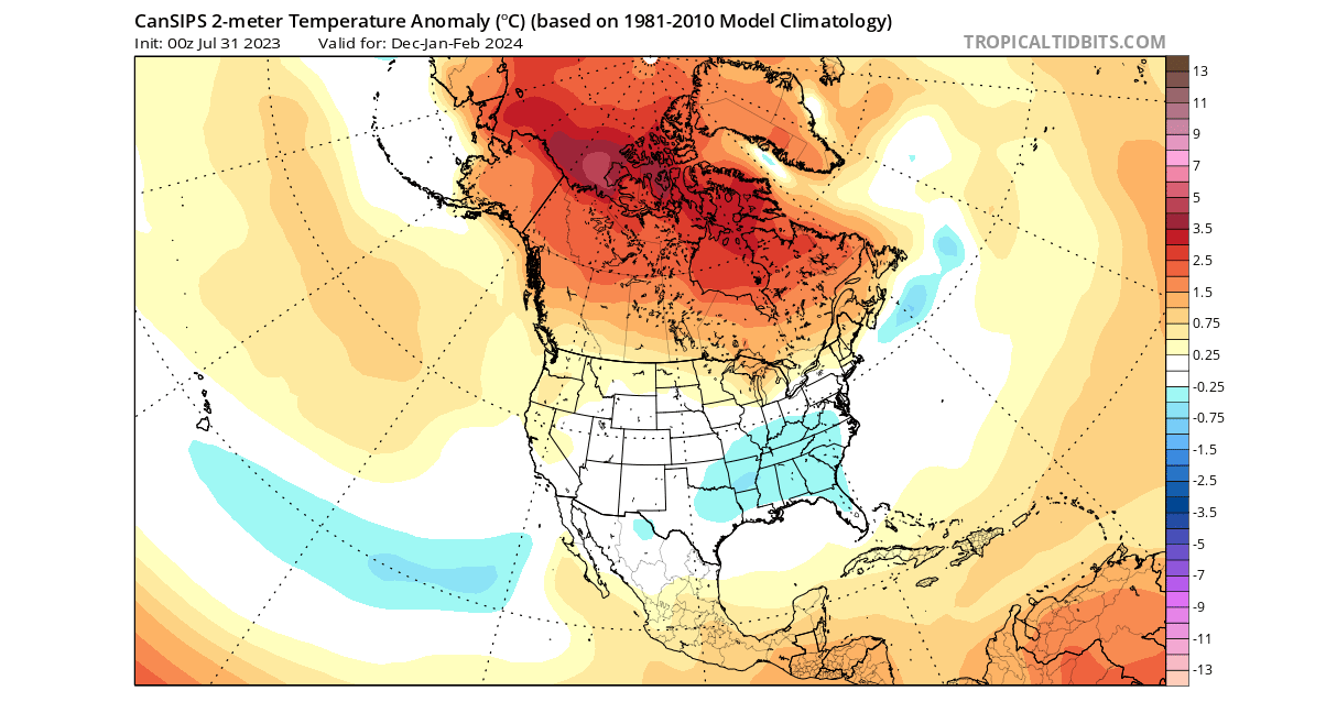
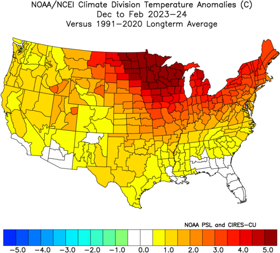
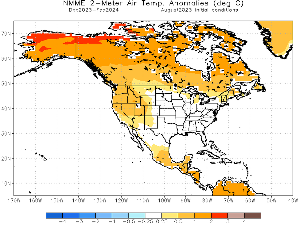
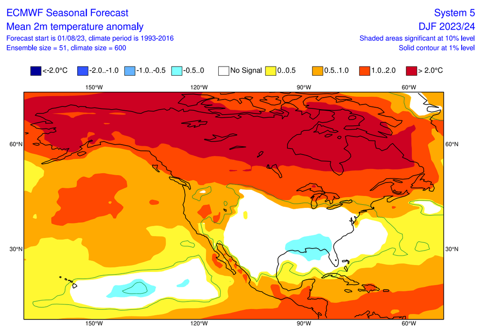
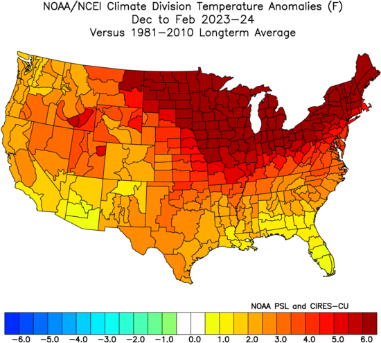
My guess with these seasonal models are that they are very simple tools that aren’t actually making a forecast. They are showing the correlations and filling in the temperatures to match. These are the forecasts issued for DJF 2023-2024 made in August. Notice how it looks like the models are just cutting and pasting a correlation map for Nino 3.4 North American temperatures without much regard to this being a super El Niño or weak El Niño. I converted the verification below to °C to match the forecasts so everything lines up correctly. I also included the cooler 1981-2010 base period for the CanSIPS which the forecast was issued in. Verification was the warmest winter on record for the CONUS

-
I let my yard go almost complete chaos this year. It might be covered with stuff but, I don't really care. The rabbits and other critters seem to love it, and what they didn't eat in the garden early is doing great. There are enough raspberries and strawberries for everyone so that's good. A solid soaking is nearly guaranteed after I washed my van yesterday.
-

Central PA Summer 2026 Discussion/Obs Thread
Jns2183 replied to Voyager's topic in Upstate New York/Pennsylvania
Some light reading Sent from my SM-S731U using Tapatalk
-
Looks like congrats @ineedsnow north on the rain; possibly .4-.9” here in E CT…. will see what happens. Wouldn’t be shocked if it wagons north and we get .25
-
.thumb.jpg.6a4895b2a43f87359e4e7d04a6fa0d14.jpg)
Central PA Summer 2026 Discussion/Obs Thread
Yardstickgozinya replied to Voyager's topic in Upstate New York/Pennsylvania
Funday Monday. Stay safe out there, fellas . - Remove Highlighting -- -- Discussion containing changed information from previous version are highlighted. -- 430 FXUS61 KCTP 220840 AFDCTP Area Forecast Discussion National Weather Service State College PA 440 AM EDT Mon Jun 22 2026 .WHAT HAS CHANGED... Level 2/5 severe T-storm risk expanded over the southern tier of central PA for this afternoon and evening && .KEY MESSAGES... 1) Scattered severe thunderstorms with locally heavy rainfall are possible across the southern tier/third of central PA this afternoon and evening && .DISCUSSION... KEY MESSAGE 1: Scattered severe thunderstorms with locally heavy rainfall possible across the southern tier/third of central PA this afternoon and evening Steady warm advection rain has expanded across the northern tier early this morning. This leading edge rain is likely tied to 850mb wind max downstream of dampening mid level shortwave trough/remnant MCV in the Ohio Valley. Hires guidance focuses mean QPF in the 0.50-0.75 inch range to the north of I-80 through 18Z with local rainfall amounts possibly exceeding 1 inch by early afternoon. Attention shifts to the south this afternoon and evening as a warm front will lift north of the MD line to a position somewhere between I-80 and US-22. Sfc dewpoints are projected to surge into the upper 60s to the south of the warm front where some cloud breaks should allow for at least modest destabilization. The moderately sheared and conditionally moist/unstable convective environment should promote scattered t-storm ignition into peak diurnal heating. The initial storm development is expected to evolve into forward propagating clusters with a strong to locally damaging wind threat. As convection intercepts the northward moving warm front over the southern tier of CPA, locally backed flow and more favorable low level shear may support the development of at least transient supercells with some tornado potential. SPC has expanded the level 2/5 slight risk to include the entire southern tier/third of CPA (areas near and south of US-22) along with corresponding severe wind and 2% tornado probs. Heavy rainfall will also be a concern with pwat values between 1.5 and 2 inches. This is around the 95th percentile for this time of year and would support intense rain rates perhaps as high as 2-3"/hr. A warm cloud depth in excess of 11,000 feet and tall, skinny CAPE profiles also support a heavy rain signal. WPC has maintained a level 2/4 slight risk for excessive rainfall (ERO) over roughly the southern third of the forecast area where isolated instances of flash flooding will be possible, particularly in training/repeat storms over urban areas. The two limiting factors going against a more considerable flash flood threat are the ongoing dryness/drought conditions focused over the LSV and fairly progressive storm motions. https://forecast.weather.gov/product.php?site=CTP&issuedby=CTP&product=AFD&format=CI&version=1&highlight=on&glossary=1 -
Central PA Summer 2026 Discussion/Obs Thread
Yardstickgozinya replied to Voyager's topic in Upstate New York/Pennsylvania
It's a 3cape day. The updated outlook should be available soon, but it seems like the days of consistency are over. ...Mid Atlantic into the Mid-South... A midlevel shortwave trough, including the remnant of a prominent MCV, is forecast to move from parts of the Upper OH Valley toward the Northeast and Mid Atlantic later today. While most guidance suggests some dampening of this shortwave trough with time, some flow enhancement will persist within the 850-500 mb layer in the wake of this shortwave across parts of the Mid Atlantic and central/southern Appalachians. Scattered storm development is expected by early/mid afternoon within a moist and moderately unstable environment. Initial development is expected to evolve into forward propagating storm clusters with a threat of damaging winds through the afternoon into the early evening. As convection intercepts a northward-moving warm front across the Mid Atlantic, locally backed flow may support development of at least transient supercells, with some tornado potential. https://www.spc.noaa.gov/products/outlook/day1otlk.html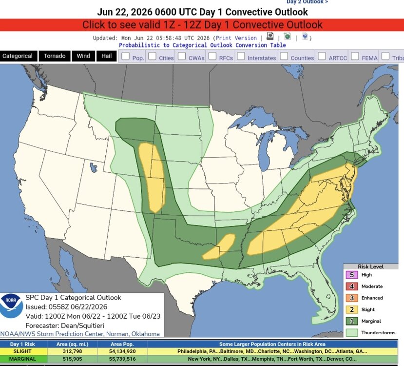
-
Central PA Summer 2026 Discussion/Obs Thread
Yardstickgozinya replied to Voyager's topic in Upstate New York/Pennsylvania
Wow, that sounds familiar. I am only speaking for myself here, but I actually had a bout of something similar about ten years prior that was much shorter in duration.. Looking back, I believe that both times I was dealing with a lot of anxiety. I really have no idea, though. Whatever it was, kept me nauseous 24/7 for well over 2 years. I would vomit at least three or four times a week. One of the other things about the whole ordeal that really p***** me off, is that the gastroentinologist also insisted that I had acid reflux and needed fundoplication . Being a much less invasive procedure, I went through with it. A few months after I had that done I develop chronic acid reflux and this time, I was sure of it, because unlike before the surgery, I actually felt like I had acid reflux. I only had it a few times in my life before that and it was from hot dogs every time. Looking back at it now I realize those sons of b****** took advantage of my health insurance. Not saying, that's what's happening to anybody else but that's surely what happened to me. -

Central PA Summer 2026 Discussion/Obs Thread
Voyager replied to Voyager's topic in Upstate New York/Pennsylvania
So what mimics IBD's. I'm in that stage right now. I was first told I had CD, then I was told there wasn't evidence of "chronic inflammation", so no official diagnosis, but my gastro believes that I do have Crohn's. I don't know. What I do know is that this started in February, and that I feel like crap far more often than I don't. -

2026-2027 Super El Nino
Stormchaserchuck1 replied to Stormchaserchuck1's topic in Weather Forecasting and Discussion
I wonder if Summer ridging at 90N is something that reverses long term, "evens out", like ENSO seems to do? We have been in a long, consistent cold period since 2016. -
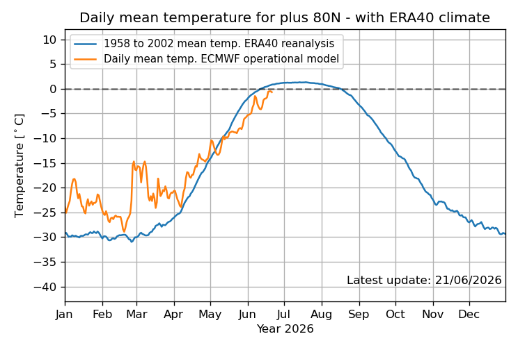
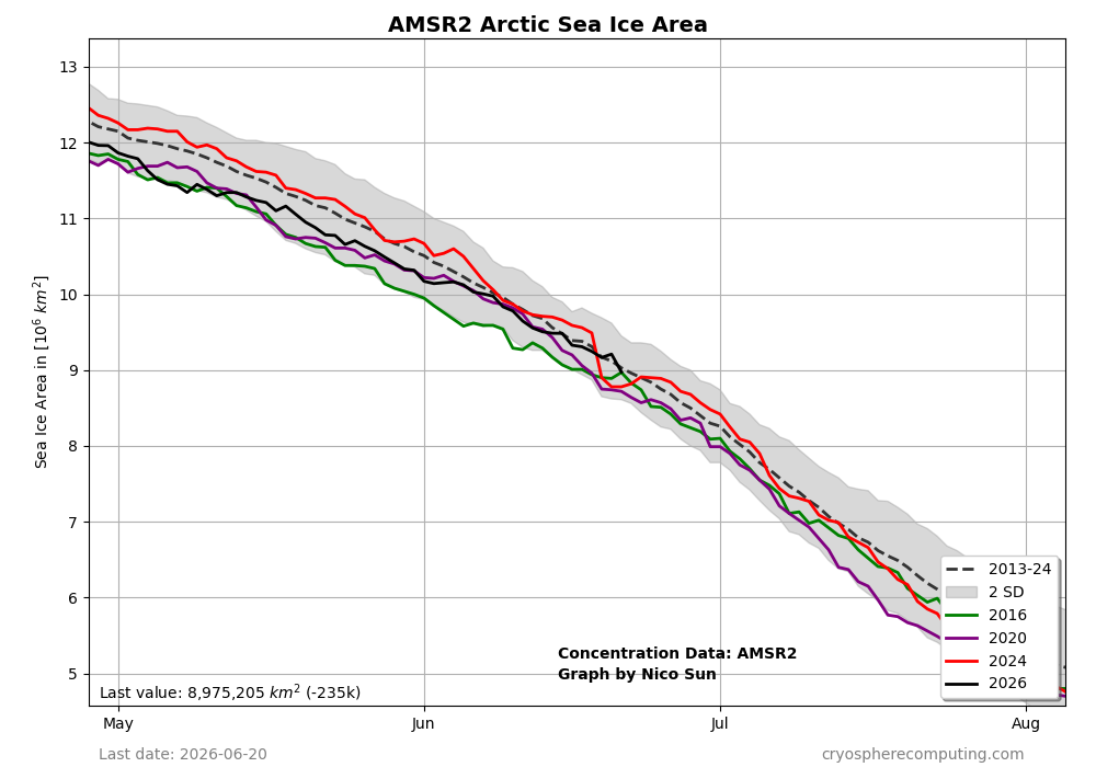
The 80N+ record lows continue as of June 21st per the Euro site as none of the years 1958-2025 have the orange line below the dotted line like 2026 continues as of June 21st. The closest are near the dotted line such as 2014, 2013, 2009, 1997, 1995, and 1986. BN has occurred every day since May 10th with 2026 being the coldest on record for that period overall: This BN period has allowed the Arctic sea ice area to recover from record lows on May 11th to the 2013-24 avg for the last week: