All Activity
- Past hour
-
Just a wild out of season warm event for the Southwest.
-
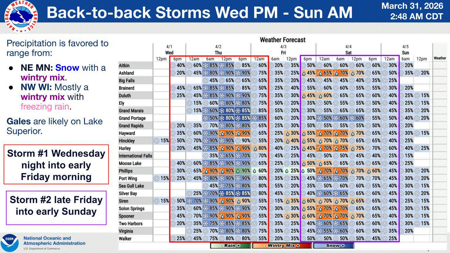
Messy wx later this week up my way. Thurs snow in N MN will be during the day which should keep any accum at minimum. Maybe a little something for Fri night into Sat am. High sun angle keeps things at a minimum. Best to hit overnight. Still in need of precip across the area, so whatever falls is much appreciated.
-
understatement. top tier evening/night for late march.
-
Perfect layout for rapid bloom in place
-
Round 2
-
I'm inclined to sell BOX high of 77 here. 72-74 seems more realistic with the cloud cover.
-
I think we had a T here with flakes in the air one day.
-
Already 70 here
-
Lfg! Months after months of connective season, just how we like it!
-
because March has 31 days
-

2026-2027 El Nino
PhiEaglesfan712 replied to Stormchaserchuck1's topic in Weather Forecasting and Discussion
Yeah, they prematurely overhyped the el nino. But by the time you got to 14-15, you just knew whenever the el nino developed, it was going to be historic. The el nino was building up for 3-4 years at that time. I'd even argue that 2024-25 was a la nina bust, as well. That one was predicted early on to be a strong la nina, but ended up as a disjointed 2-year la nina. -
Get under something
-
I think his mother is the woman who's face is just to the right of the ball.
-
A few decent downpours
-
How is it still March?
-
The Euro is prone to being too warm with ONI, sometimes by a lot: It in 3/2014 predicted a +1.3 ONI for JAS vs only +0.1 that verified It progged in 4/2014 +1.4 for ASO vs only +0.3 that verified Euro progged in 5/2014 +1.5 for ASO vs only +0.3 that verified It progged in 4/2012 +1.0 for ASO vs only +0.4 that verified It progged in 5/2012 +1.0 for SON vs only +0.3 that verified It progged in 6/2012 +1.2 for OND vs only +0.1 that verified I’m not even talking about RONI, which as of now is ~0.5 cooler than ONI. Sources: Euro progs https://iri.columbia.edu/our-expertise/climate/forecasts/enso/2014-June-quick-look/?enso_tab=enso-sst_table ONI: https://www.cpc.ncep.noaa.gov/data/indices/oni.ascii.txt
-

Central PA Spring 2026 Discussion/Obs Thread
Mount Joy Snowman replied to Voyager's topic in Upstate New York/Pennsylvania
Never heard of either of these places -- national high of 101 at Cibola, AZ and low of 7 at Saint Mary, MT. 7-day precip map shows the contrast from SE to NW across the state. -
Agreed. Today's max will be the 47 late last evening. Now we're mid 30s with -RA. Maybe we get enough rain to matter, though March will be the 9th BN month of the most recent 10, and the one AN month (Sept) was only 0.19" above. Precip for those 10 months is running 61% of average, might climb all the way to 62% by today's end. Grandkids are getting the torch in SNJ - 80 today and 83/65 progged for tomorrow. That mean of 74 is 25° AN for there.
-
Overcast with snow shwrs this morning. T of snow.
-
Decent call here. Front working its way through today into tomorrow with shwrs/stms, and a little snow up N. Active pattern for the 1st week of April.

-
A few breaks poking through. Thinking we can touch the mid 50's today that continues. Yesterday was too f'n windy and didn't even touch 50.
-
Had .20" here but I get your point. The .20" received here in March got me to an even 50" for the season.
-
Another cloudy, gross day
-

2026-2027 El Nino
Stormchaserchuck1 replied to Stormchaserchuck1's topic in Weather Forecasting and Discussion
PDO isn't as strongly connected to ENSO as you would think.. here are the Strongest El Nino's. 2 other areas in the globe have bigger anomalies