All Activity
- Past hour
-
GFS is heavy rain pretty far into the interior on its 0z run.
-

December 2025 regional war/obs/disco thread
TauntonBlizzard2013 replied to Torch Tiger's topic in New England
Gfs is still really amped, but might be slightly toned down from 18z. At least the backside flip is prominent -
Way north. Low plows into SE mass.
-
GFS nukes up here though.
-
just covering for ineedicon. He seems to be missing when a model trends this direction. I’m sure it’s just coincidence.
-
GFS...............
-
Its over, Next.
-
I don’t think snow is in the cards for many of us anywhere near I-95, along I-95, or east of it. You would need high pressure to be anchored to funnel cold down into an amplifying storm, and climatology isn’t in our favor this early in the season anyway. For I-84 and north, I’d say it’s definitely likely they’ll get some snow out of it. But south of there is quite difficult this early in the season, especially without much cold air to work with
-
Bengals can make this a blowout real quick. I think they will.
-
I remember Robert's obvs posts during the 2009 snowstorm that broke a pine tree and damaged his house. He was truly one of the best. I also won't forget those late nights with Burgertime..... he still posts from time to time.
-
It’s AIFS Ens or bust at this point. Fun early season exercise at the least. Hope we get to try again sooner rather then later
-
ICON less amped/south
-
Just comical.
-
Not at all. Less confluence and higher heights. This one is slipping away
-

Winter 2025-26 Medium/Long Range Discussion
Chicago916 replied to michsnowfreak's topic in Lakes/Ohio Valley
Doesn't mean much, but seems like next week's storm has continued to trend north. Looks like better spacing with this weekends storm. Doesn't look particularly strong tho but something to watch. -

Nov 28-30th Post Turkey Day Wintry Potential
migratingwx replied to Chicago Storm's topic in Lakes/Ohio Valley
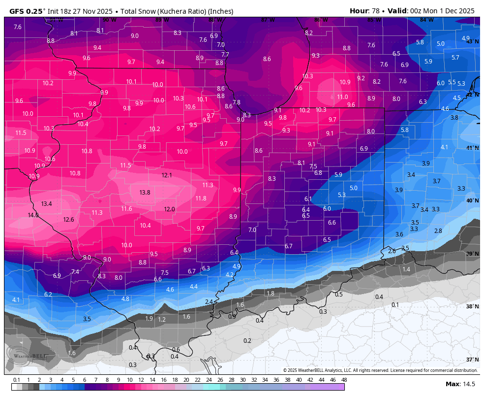
00z vs 18z below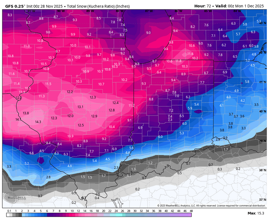

-

Nov 28-30th Post Turkey Day Wintry Potential
HillsdaleMIWeather replied to Chicago Storm's topic in Lakes/Ohio Valley
Real Weenie Time -
Nov 28-30th Post Turkey Day Wintry Potential
Paulie21 replied to Chicago Storm's topic in Lakes/Ohio Valley
I think 8-10” is fair forecast. Thinking 16 hours + of snow. Averaging 1/2” per hour ish. Wherever this enhanced H5 band of UVV's lands will definitely have some higher rates/bigger flakes, liking I-88 to I-90 corridor (for now). Wouldn't rule out some stray TSSN in this weenie band.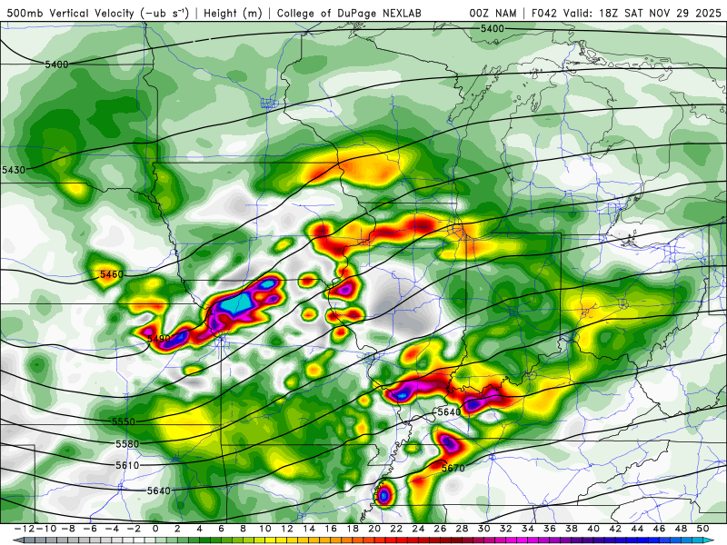
-
Not to preemptively call it but I don't think the GFS is going to be what we need it to be.
-
You know it's a weird season in the AFC when the Chiefs and Ravens could be 6-6, lol
-

December 2025 regional war/obs/disco thread
bristolri_wx replied to Torch Tiger's topic in New England
00z GFS rolling in. Will we see 60"+ somewhere on this run? Or 6" of rain? -
And look and behold...they are! And Nate Wiggins being out could be the final nail in this one, smh
-

Nov 28-30th Post Turkey Day Wintry Potential
Sciascia replied to Chicago Storm's topic in Lakes/Ohio Valley
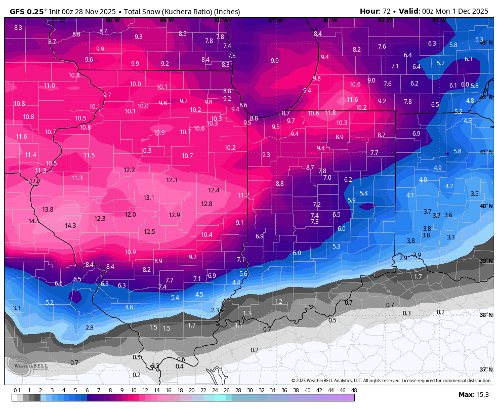
00z GFS nearly a carbon copy of 18z in terms of snow amounts -

Nov 28-30th Post Turkey Day Wintry Potential
nwohweather replied to Chicago Storm's topic in Lakes/Ohio Valley
Shocked there hasn’t been a huge March north. I’d lean 2-4” for Toledo and 3-6” for places west of I-75 to the border -
He’s in a good spot there maybe it’s seven or 8 miles, but like it’s not the difference of Saranac Lake versus Albany.