All Activity
- Past hour
-
There was/is a very questionable theory that high Atlantic ACE with recurving hurricanes during a -ENSO results in -NAO blocking in winter. I have seen zero hard, convincing evidence that high Atlantic ACE with recurving hurricanes during -ENSOs (La Nina’s/cold-neutrals) cause -NAO blocking in winter. JB has been the biggest pusher of this unproven theory ever since the 1995-96 winter because of the ‘95 Atlantic hurricane season that preceded it
-

Hurricane Erin: 160 MPH - 917mb - W @ 17
Windspeed replied to BarryStantonGBP's topic in Tropical Headquarters
St. Maarten's radar is in closer proximity to Erin's core and, therefore, has better returns from the northern semicircle of Erin's outer circulation. As such, concentric banding is a little more evident here. Perhaps even with a moat forming in-between the northern outer band and Erin's northern eyewall. So we may not be long from an EWRC initiating now during peak intensity. Very thankful recon made those few final passes earlier. -
Anthony's last name is Bell I can't back that up.
-
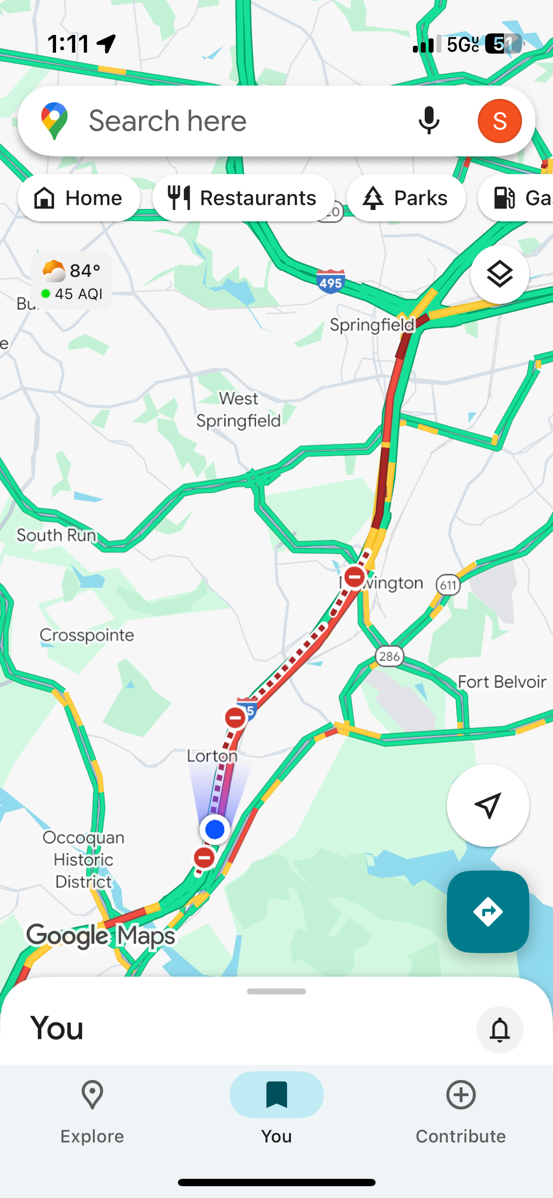
Confirmed. We’re passing it now. Accident in the southbound express.
-
Euro west of 6z through 72
-
Comment on Waze that the backup is due to rubbernecking. Yeah, that tracks.
-

Hurricane Erin: 160 MPH - 917mb - W @ 17
Kevin Reilly replied to BarryStantonGBP's topic in Tropical Headquarters
How does 2024 July 1st Beryl rank -
I picked up 0.23” out of it. Yeah watching that batch up on the county line and NW Fred Co. Does not look to be moving much south.
-
Perhaps the middle name and only if Liberty passes Anthony’s post count by the birth. As always …..
-
Hurricane Erin: 160 MPH - 917mb - W @ 17
Windspeed replied to BarryStantonGBP's topic in Tropical Headquarters
Not really anything impressive yet with regards to concentric banding around Erin's donut of an eyewall. Granted, this is a good distance away from San Juan's radar tower. Erin continues to have a small but stable eyewall for now. -
It's very scary, like a line of fog that's quickly approaching.
-
Another beautiful Saturday in northern VA
-
It does sound Italian....
-

Mid to long range discussion- 2025
WinstonSalemArlington replied to wncsnow's topic in Southeastern States
-
you guys share the same gods too (I mean the ancient cultures in each group of course lol), the Romans just changed the names lol
-
 ugh the state Mesonet is too coarse, they have one station in Nassau County and it's in Wantagh and I might as well use FRG lol. I'm like 15 miles west of there.
 -
Meh here. Only 4 days with thunder and except one strike about 3 miles distant last May, nothing has come within 5 miles. Average here thru mid-August is 11 and lowest thru 8/31 is 8, in 2010 (also that year's total).
-
What is the reasoning for why ACE would matter so much for the winter pattern? It's kind of hard to accept at face value that any heat transfer now would matter say 3-6 months later. It also seems like the ACE calculation is flawed since it doesn't take storm size into account. A little storm like this is treated the same as a much broader one right?
-
Only one clap of thunder here. It rained briefly, but no flush hits recently. Sun is popping back out, so maybe that’ll energize things with that trailing batch near Hagerstown.
-
One can't even calculate how many feet of snow we would have received from such speculations.
-
Liberty.
-
79/70 here
-
You can absolutely see snow squalls coming at you, and it is assume.
-

Hurricane Erin: 160 MPH - 917mb - W @ 17
TriPol replied to BarryStantonGBP's topic in Tropical Headquarters
This is why we’re weather weenies… for storms like Erin. -

Hurricane Erin: 160 MPH - 917mb - W @ 17
Stormchaserchuck1 replied to BarryStantonGBP's topic in Tropical Headquarters
3rd year in a row with top 1% Rapid Intensification 2023 was Lee 2024 was Milton 2025 Erin