All Activity
- Past hour
-

E PA/NJ/DE Autumn 2026 Obs/Discussion
JTA66 replied to PhiEaglesfan712's topic in Philadelphia Region
You can feel the humidity creeping up again. Oh well, it was fun while it lasted. 77F/DP 65F -
Who is saying it will be? Most I see are saying it's likely to be warm and wet but at least we have a chance to score one huge snowstorm if we get lucky and time up one of the storms with cold...which is what all the east based strong nino's indicate is our fate.
-
I beleaf the leaves are going to be pretty solidly changed for my vacation next week, very hyped.
-
 over the counter sildenafil [url=https://getbelvion.shop/#]GetBelvion[/url] Cheap generic Viagra
 -
Mm we may have difference source but these on this CDC site beginning late 1970s thru recency ... there's a clear bias for between Xmas and mid January. https://www.cpc.ncep.noaa.gov/products/stratosphere/strat-trop/
-
I hope November is nice or October-like. Imo that’s our most garbage weather month. December is a close 2nd. Holidays are their only redeeming quality.
-

Septorcher 2026 Discussion - Endless Summer
weatherwiz replied to Damage In Tolland's topic in New England
We'll have to see if anything develops. It's been humorous at times with the GFS and its fantasy canes even some other long-range guidance at times trying to develop stuff...almost like because "there has to be something". Even this I think is way overdone. What I think could happen though is there may be brief periods of small geo-spatial areas where conditions are favorable and if a wave hits these areas it might form into something but any life span is going to be very short-lived. -
п»їcialis generic: menon36 - Cheap Cialis
- Today
-

Septorcher 2026 Discussion - Endless Summer
WxWatcher007 replied to Damage In Tolland's topic in New England
Fairly active in the Atlantic. -
So high cirrus and mid 50s. Got it.
-
September 16 2006: A rapidly forming tornado hits Rogers just before 10pm, causing one fatality. 1992: New Market receives nearly a foot of rain. A bridge collapses during a flood in northern Le Sueur County. 1955: An F1 tornado touches down in Mille Lacs and Kanabec Counties, causing 1 fatality and $500,000 in damages. For Wednesday, September 16, 2026 1881 - Iowa's earliest measurable snow of record fell over western sections of the state. Four to six inches was reported between Stuart and Avoca. (The Weather Channel) 1928 - Hurricane San Felipe, a monster hurricane, which left 600 dead in Guadeloupe, and 300 dead in Puerto Rico, struck West Palm Beach FL causing enormous damage, and then headed for Lake Okeechobee. When the storm was over, the lake covered an area the size of the state of Delaware, and beneath its waters were 2000 victims. The only survivors were those who reached large hotels for safety, and a group of fifty people who got onto a raft to take their chances out in the middle of the lake. (David Ludlum) 1961 - Hurricane Esther was seeded by Navy planes in the inaugural experiment of what was to formally become Project STORMFURY next year. Esther was the first hurricane to be initially detected by satellite. On Sept. 10th, TIROS III imaged an area of disturbed weather a hundred miles southwest of the Cabo Verde Islands. 1984 - The remains of Tropical Storm Edourd began to produce torrential rains in the Lower Rio Grande Valley of Texas. Port Isabel reported more than 21 inches. (The Weather Channel) 1987 - Overnight rains soaked Arkansas, with 5.25 inches reported at Bismarck. In the town of Malvern, up to four feet of water was reported over several downtown streets, with water entering some homes and businesses. Thunderstorms in Texas drenched Lufkin with 4.30 inches of rain in just three hours. Evening thunderstorms produced severe weather in Missouri. A small tornado near Kirksville lifted a barn thirty feet into the air and then demolished it. (The National Weather Summary) (Storm Data) 1988 - Hurricane Gilbert moved ashore into Mexico. The hurricane established an all-time record for the western hemisphere with a barometric reading of 26.13 inches. Winds approached 200 mph, with higher gusts. Gilbert devastated Jamaica and the Yucatan Peninsula. (The Weather Channel) Hurricane Gilbert made landfall 120 miles south of Brownsville TX during the early evening. Winds gusted to 61 mph at Brownsville, and reached 82 mph at Padre Island. Six foot tides eroded three to four feet off beaches along the Lower Texas Coast, leaving the waterline seventy-five feet farther inland. Rainfall totals ranged up to 8.71 inches at Lamar TX. Gilbert caused three million dollars damage along the Lower Texas Coast, but less than a million dollars damage along the Middle Texas Coast. (The National Weather Summary) (Storm Data) 1989 - Showers and thunderstorms, respresenting what remained of Hurricane Octave, brought locally heavy rains to California, impeding the drying process for raisins and other crops. Sacramento CA was soaked with 1.53 inches of rain in six hours. At Phoenix AZ, the afternoon high of 107 degrees marked a record seventy-six days with afternoon highs 105 degrees or above. (The National Weather Summary) (Storm Data) 2004 - Hurricane Ivan turned northward over cooler waters, and made landfall in southern Alabama as a Category 3 storm. Hurricane Ivan had a very unusual track almost making a huge circle. Observances: 17 Thu Citizenship Day 17 Thu National Pet Bird Day 17 Thu International Country Music Day 17 Thu Constitution Day 17 Thu Time's Up Day 17 Thu World Patient Safety Day 17 Thu International Patient Safety Day 17 Thu International Grenache Day 17 Thu National Arielle K. Sterrett Day 17 Thu National DEI Day 17 Thu National Monte Cristo Day 17 Thu National Pet Carbon Monoxide (CO) Safety Day 17 Thu National Professional House Cleaners Day 17 Thu National Table Shuffleboard Day 17 Thu Smithsonian Day 17 Thu National Apple Dumpling Day
-
Yeah what got me is that I read the forecast in the newspaper 5 days out. I got over 30 inches. Heavy snow compacted by insane winds. While shoveling, I saw a neighbor drop to the ground literally dead while he was operating a snowblower. I tried to render aid, but he had aortic dissection turns out so there was no hope. Obviously I didn't know that then but just had to keep trying. The ambulance took 30 minutes to get there. I will never forget that storm!
-

Septorcher 2026 Discussion - Endless Summer
Brian5671 replied to Damage In Tolland's topic in New England
72 here as more humid air makes inroads...sun coming out too -
I see the forecast next week is already clear as mud lol
-
6z euro ai said one of his projects should be building an ark
-
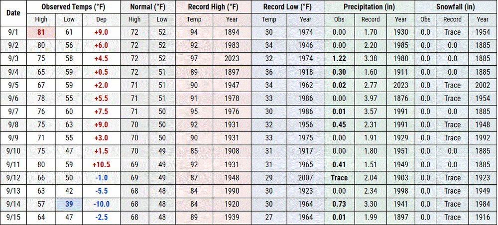
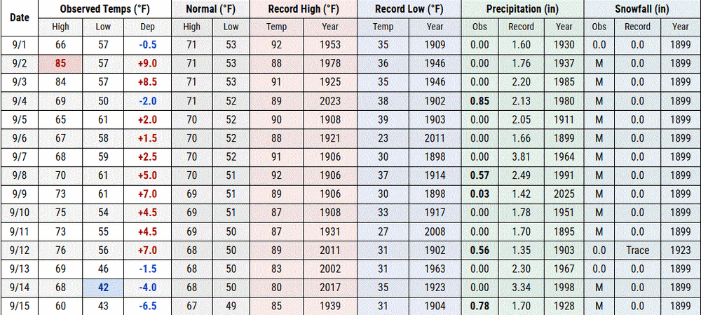
30's -40's this morning. 60's today. First half of Sept round up. DLH TH
-

Septorcher 2026 Discussion - Endless Summer
Brewbeer replied to Damage In Tolland's topic in New England
if your definition of "torch" covers everything from -5 to +10, then yes, yes it is, today is a "torch" 67/60 in the 'hood -
-
6z gfs say go ahead schedule more projects
-
Cialis over the counter: Men On 36 - Generic Cialis price
-

Central PA Summer 2026 Discussion/Obs Thread
WmsptWx replied to Voyager's topic in Upstate New York/Pennsylvania
Did David intend to make that look like an Emergency Alert System scare graphic? LOL -
Just as an aside, SSW climo time frame isn't late autumn and early winter.... mid winter, okay....last season was very rare in that regard.
-
Records: Highs: EWR: 95 (1991) NYC: 93 (1915) LGA: 95 (1991) JFK: 89 (1991) Lows: EWR: 42 (1984) NYC: 47 (1966) LGA: 48 (1984) JFK: 48 (1959) Historical: 1875: A hurricane stuck Indianola, TX killing 176 people. 75% of the town was swept away from the disastrous storm surge. The highest wind registered was 88 mph before the anemometer blew away. (Ref. Wilson Wx. History) 1881 - Iowa's earliest measurable snow of record fell over western sections of the state. Four to six inches was reported between Stuart and Avoca. (The Weather Channel) 1888: An estimated F2 tornado struck Washington, DC. The tornado first touched down on the south side of the city then moved up Maryland Avenue. The National Museum and Botanical Gardens were damaged before the tornado lifted off the ground. 1928 - Hurricane San Felipe, a monster hurricane, which left 600 dead in Guadeloupe, and 300 dead in Puerto Rico, struck West Palm Beach FL causing enormous damage, and then headed for Lake Okeechobee. When the storm was over, the lake covered an area the size of the state of Delaware, and beneath its waters were 2000 victims. The only survivors were those who reached large hotels for safety, and a group of fifty people who got onto a raft to take their chances out in the middle of the lake. (David Ludlum) 1915: Boston, Massachusetts has the warmest minimum temperature of 76 °F for the month of September. (Ref. NOAA Boston Weather Events) 1928: The Okeechobee Hurricane, also known as the San Felipe Segundo Hurricane was one of the deadliest hurricanes in the history of the Atlantic basin. This Hurricane made landfall near West Palm Beach, Florida as a Category 4 storm during the evening hours of the 16th. The storm surge caused water to pour out of the southern edge of Lake Okeechobee, flooding hundreds of square miles as high as 20 feet. This storm killed over 4,000 people, including 2,500 in Florida. 1933: The second major hurricane of the very busy season struck the North Carolina coast near New Bern with maximum sustained winds of 120 mph and a central pressure of 957 millibars or 28.26 inches of mercury. 76 mph winds were reported at Cape Hatteras, NC. 21 people died and significant damage was reported in Virginia and Maryland. Damage was set at $1 million dollars. The Category 3 storm followed on the heels of the damaging Chesapeake – Potomac Hurricane, which struck the coast in late August (Ref. AccWeather Weather History) 1961 - Hurricane Esther was seeded by Navy planes in the inaugural experiment of what was to formally become Project STORMFURY next year. Esther was the first hurricane to be initially detected by satellite. On Sept. 10th, TIROS III imaged an area of disturbed weather a hundred miles southwest of the Cabo Verde Islands. 1964: Concord, NH recorded a morning low of 27°, making this the shortest growing season on record at just 100 days.(Ref. AccWeather Weather History) 1965: Rawlins, WY recorded their greatest daily precipitation on record as 2.06 inches of precipitation fell, including 14.5 inches of snow.(Ref. Wilson Wx. History) 1967: Hurricane Doria formed off Florida and moved northeast into the Atlantic. However, it reversed course and moved west to the lower Delmarva coast as a hurricane, then turned southwest, making landfall north of Cape Hatteras, NC as a tropical storm. This is a historic hurricane for two reasons. It was the 1st time on record that a tropical system made landfall north of Cape Hatteras, moving from the northeast. Also on this date, a noteworthy first occurred in satellite photography when Doria, Hurricane Chloe, southeast of Nova Scotia, Canada and Hurricane Beulah, about to move into Mexico’s Yucatan Peninsula, were all photographed on the same orbital pass by ESSA 2. (Ref. Wilson Wx. History) 1971: A record breaking early fall snow storm caused extensive damage to trees and utility lines. The heavy wet snow occurred with little wind but caused record breaking cold temperatures for so early in the season. Snowfall totaled 15.6 inches at Stapleton International Airport with most of the snowfall 12.0 inches occurring on the 17th. This was the heaviest first snow of the season. The maximum snow depth on the ground was 13 inches. Record low temperatures were set on three consecutive days: 31 degrees on the 17th 23 degrees on the 18th and 20 degrees on the 19th which was also a new all-time record minimum for the month at that time. Record low maximum temperatures were set on 4 consecutive days: 48 degrees on the 16th 35 degrees on the 17th 40 degrees on the 18th and 42 degrees on the 19th. Tony Hake Providing Local Weather for Thornton, Colorado (http://www.thorntonweather.com) Early Denver CO Snow 1984 - The remains of Tropical Storm Edourd began to produce torrential rains in the Lower Rio Grande Valley of Texas. Port Isabel reported more than 21 inches. (The Weather Channel) 1987 - Overnight rains soaked Arkansas, with 5.25 inches reported at Bismarck. In the town of Malvern, up to four feet of water was reported over several downtown streets, with water entering some homes and businesses. Thunderstorms in Texas drenched Lufkin with 4.30 inches of rain in just three hours. Evening thunderstorms produced severe weather in Missouri. A small tornado near Kirksville lifted a barn thirty feet into the air and then demolished it. (The National Weather Summary) (Storm Data) 1988 - Hurricane Gilbert moved ashore into Mexico. The hurricane established an all-time record for the western hemisphere with a barometric reading of 26.13 inches. Winds approached 200 mph, with higher gusts. Gilbert devastated Jamaica and the Yucatan Peninsula. (The Weather Channel) Hurricane Gilbert made landfall 120 miles south of Brownsville TX during the early evening. Winds gusted to 61 mph at Brownsville, and reached 82 mph at Padre Island. Six foot tides eroded three to four feet off beaches along the Lower Texas Coast, leaving the waterline seventy-five feet farther inland. Rainfall totals ranged up to 8.71 inches at Lamar TX. Gilbert caused three million dollars damage along the Lower Texas Coast, but less than a million dollars damage along the Middle Texas Coast. (The National Weather Summary) (Storm Data) 1989 - Showers and thunderstorms, respresenting what remained of Hurricane Octave, brought locally heavy rains to California, impeding the drying process for raisins and other crops. Sacramento CA was soaked with 1.53 inches of rain in six hours. At Phoenix AZ, the afternoon high of 107 degrees marked a record seventy-six days with afternoon highs 105 degrees or above. (The National Weather Summary) (Storm Data) 1996: Two weeks after Hurricane Fran lashed eastern North Carolina with torrential flooding rains and 115 mph winds, at least three damaging tornadoes spun through the same communities from severe thunderstorms. (Ref. AccWeather Weather History) 1999: The remnants of Hurricane Floyd caused major flooding to North Carolina. More than 10 inches of rain fell in a swath from North Carolina to New Jersey. Many streams in the targeted areas reached 100-year and, in some instances, 500-year predicted levels. It ranks among eastern North Carolina, southeastern Virginia, the central and northern Delmarva Peninsula, and New Jersey's most destructive flood disasters. Floyd's Track - Weather Underground (Ref. More Information About Floyd) 2000: The record high of 95° at Denver, Co set three records: 1.) New record high for the date. 2.) The warmest reading for this late in the year. 3.) It marked the 60th day during the year the temperature reached 90° or above, tying the record set back in 1994. Miles City, MT hit 100°, their latest 100 degree reading on record. (Ref. Wilson Wx. History) 2004 - Hurricane Ivan turned northward over cooler waters, and made landfall in southern Alabama as a Category 3 storm. Hurricane Ivan had a very unusual track almost making a huge circle.
-
https://menon36.shop/# Generic Tadalafil 20mg price
-
67 / 59 : some clouds and showers as the warm front and ridge builds around Tennessee. Warm 72 hours / warmer inland. Have to watch the weekend and early next week for cutoff and / or stalled front which could lead to a cloudy / rainy cool 9/20 - 9/23. Beyond there overall near normal.