All Activity
- Past hour
-

"Don’t do it" 2026 Blizzard obs, updates and pictures.
andyhb replied to Ginx snewx's topic in New England
A 3 footer at an official obs site for a major city would be insane, and I think that's becoming pretty likely. -

"Don’t do it" 2026 Blizzard obs, updates and pictures.
40/70 Benchmark replied to Ginx snewx's topic in New England
Won't hold a candle to 78 regionally....only grazed the area compared to that one. The 75 mile slip south killed that. -
The zookeeper's trying to find a spot under 20". No luck so far. He'll update when he finds it
-

Feb 22nd/23rd "There's no way..." Obs Thread
ravensrule replied to Maestrobjwa's topic in Mid Atlantic
We're honestly going to miss you. Please stop by and say hello once in a while. -
what I'd give to be able to reexperience GHD with the capacity to appreciate it to the extent it deserved Relatively fresh-off-the-boat yung malakuh simultaneously didn't know such a thing was possible nor how rare it was for here
-
That is one persistent band over the Five Boroughs! A heavy part of that band is hammering the area around Neptune, NJ now. Still in moderate snowfall, here.
-
"Don’t do it" 2026 Blizzard obs, updates and pictures.
40/70 Benchmark replied to Ginx snewx's topic in New England
Damn climate change got you again!! -

"Don’t do it" 2026 Blizzard obs, updates and pictures.
TheSnowman replied to Ginx snewx's topic in New England
Just Came Across Live TV!! BIGGEST STORM IN PROVIDENCE HISTORY. 32.8” **The BLIZZARD OF 1978 has FALLEN** -
This is where the under performers gather to let go and look forward. Welcome to our support group.
-

"Don’t do it" 2026 Blizzard obs, updates and pictures.
DavisStraight replied to Ginx snewx's topic in New England
My dog just hops through the drifts like a bunny rabbit, she's a bigger snow weenie than me. -

"Don’t do it" 2026 Blizzard obs, updates and pictures.
WinterWolf replied to Ginx snewx's topic in New England
Yup, me too. It looked very impressive, but the big banding kept just missing, or we’d just catch the edge of them. Bad fortune is all. Too bad. Above average already for the entire winter, so we take. -

Feb 22nd/23rd "There's no way..." Obs Thread
WEATHER53 replied to Maestrobjwa's topic in Mid Atlantic
The crybaby I’m stomping out, we’ll get nothing, it’s over (before it’s started) bullshit to end Maybe there is a way that when such declarations are made, you are indeed out for 12-24 hours?? -
24 hours of snowfall now for my location.
-
I know its just dumb luck but TWC had most of Berks in the 3-5" and never budged. I think their forecasts are just copy paste of gfs output? Its just crazy how modeling played out with this storm. GFS definitely had the right idea early and didnt flinch. Obviously shifted totals around through out the week but gfs knew this would be a wound up system while every other model struggled with that. Then GFS started shifting east a couple days out but we kinda dismissed it and rode the NAM and Hrrr with their insane totals well north and west. Both those models shifted way east but only right before game time. I guess the signs were there for us north and west. I think the NWS doubling down and holding onto high totals gave us a false sense of security lol. The writing was on the wall and im never putting that much trust in the NAM more than 24 hours out from a storm. Does it suck? Yea but life goes on. Still happy a good chunk of the forum cashed in. I didnt have to miss work, barely any clean up. Ya know, silver lining coping going on over here. Sent from my SM-S938U using Tapatalk
-

"Don’t do it" 2026 Blizzard obs, updates and pictures.
Cold Miser replied to Ginx snewx's topic in New England
Are you putting snowstorm whinning in the same category as the Brown Shooting and the Pawtucket hockey shooting? Yikes. -

"Don’t do it" 2026 Blizzard obs, updates and pictures.
dan11295 replied to Ginx snewx's topic in New England
0100 PM Snow TF Green AP 41.72N 71.43W 02/23/2026 M32.8 Inch Kent RI Official NWS Obs -

"Don’t do it" 2026 Blizzard obs, updates and pictures.
NSwx replied to Ginx snewx's topic in New England
Full on blizzard down here in Shelburne county. Drifts are to the windows of my house already. -

"Don’t do it" 2026 Blizzard obs, updates and pictures.
mattm4242 replied to Ginx snewx's topic in New England
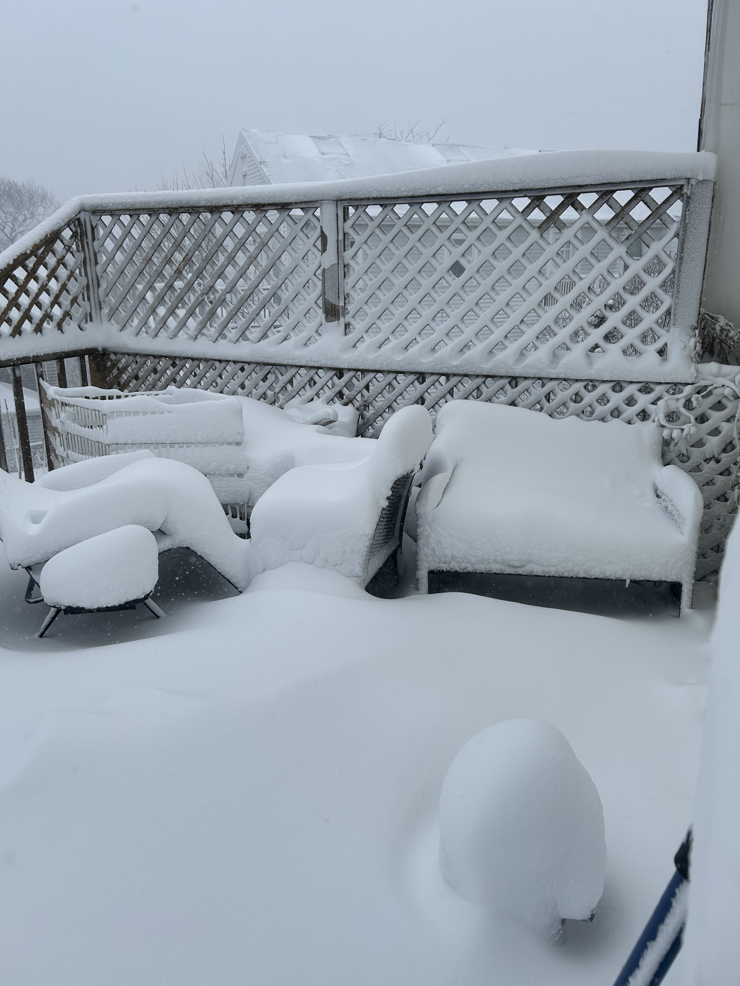
No clue what we have, but this is all new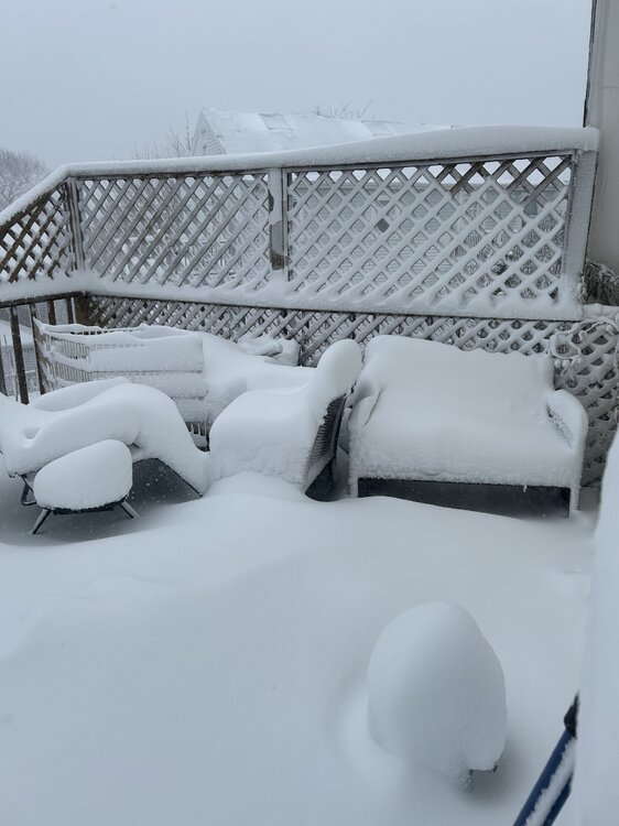
-
I feel really old atm, I went outside and part of me felt this is too much.
-
Nothing yet. .
-
It's over folks! Lets get those 50s 60s 70s
-
Worcester, PA. Ended up with approx. 12". Accuweather was a little slow to get there, but with some adjustments their forecast of 10-14 was right on with my 12". I watched that "death band" last night and it just struggled to move into Montgomery County from Bucks. Not surprised western Chester and Berks came up short in the end. Kind of what was pretty much forecasted with all the talk of a sharp cutoff to the western edge. If anything seemed overdone (to me locally) in the end was the NWS PHL statement at 10:30 last night of an additional 10 to 16" after 11 PM or so. We did get a few more inches , but i don't think anywhere near that. It may have been worded that select areas to the east of me would get that. I'm not sure. I guess if that death band had come 15 miles further west it would have verified. I am very aware they cover a wide range of territory and the variances in location, elevation, etc, etc. make it an impossible task to have a forecast or comment apply to all. It appeared to me that the temp getting down to 29 last evening may have saved us from power issues with the snow becoming drier and not clinging to the trees as much. Our trees were loaded, but not many power outages as could have been if the flakes had been bigger and wetter. By midnight i saw light blowing snow as compared to what could have been. If I have a complaint with the posters on the forum - I wish everyone would just add their location on posts or in their visible profile on the left side as it is difficult to know where they are and the forum covers a huge area. We are big on IMBY and for the most part few know where your backyard is. Ex - If you say 34 and light rain. Are you in the Poconos or Delaware. (My 2 cents)
-

"Don’t do it" 2026 Blizzard obs, updates and pictures.
OceanStWx replied to Ginx snewx's topic in New England
I'm just doing the math from the 5 inches on the ground at 7 pm last night before the snow started. -

"Don’t do it" 2026 Blizzard obs, updates and pictures.
Wonkis replied to Ginx snewx's topic in New England
I think KPVD is close to getting its seasonal average snow total (~33 inches) with this one storm edit: 4–5 inches shy apparently -