All Activity
- Past hour
-
.thumb.png.4150b06c63a21f61052e47a612bf1818.png)
December 2025 regional war/obs/disco thread
HIPPYVALLEY replied to Torch Tiger's topic in New England
Lol, 9° with DP of 3° at 8:30pm, That’s chilly. -
Check your posts from last Feb. I remember when one of the TOR crew said they had 26" depth you asking if that was the deepest he ever seen? Would be in the thread for the last event for which GRR had me under a Watch, only to cancel it by the next update when it became obv the storm wasn't going to get its act together in time for SWMI. Then even DTX said "miss SE stank" after AFD's were talking crippling bliz for the Thumb. It all ended up hitting TOR.
-

Ice Ice Baby December 28-29 Storm Discussion
VivaManchVegas replied to Baroclinic Zone's topic in New England
SNH could be in for a problem Monday morning. Not a December 2008 issue but something to monitor. Latest HRR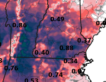
-

Winter 2025-2026 Offers Return to Normalcy
40/70 Benchmark replied to 40/70 Benchmark's topic in New England
I agree that is a big miss on that central area, but I still sent B- bc the rest of the forecast was essentially perfect...but yea, I had pause. I am usually a pretty tough grader, but gave myself about bone there...many outlets were also too robust in the max area, too...hell, NWS went 8-12". I was torn between B- and C+, so that is reasonable. -
Already down to 16⁰....unless we start getting some return flow and or clouds later on, its off to the races for radiators....clear, calm, and a fresh 7 inches of powder, should be the coldest of the season, at least here
-
January 2026 regional war/obs/disco thread
40/70 Benchmark replied to Baroclinic Zone's topic in New England
Even Tippy's 882DM Miami rule is met there, but easy to do at hr 222. -
January 2026 regional war/obs/disco thread
40/70 Benchmark replied to Baroclinic Zone's topic in New England
No, not him...but he likes January, too. I don't speak with Dave much via DM. -
Lol...feel better?
-
You can’t go by the maps, use the lat/lon
-
Lamar has gotten so much hate this week. Now maybe I'm wrong about his injury but...from what I understand this is a different thing than cracked ribs, as it's about range of motion. Calling him soft/a wuss and accusing him of quitting on his team nasty work, imo It just goes to show you that no matter how good of a person you are...some people will still find reasons to hate you, smh
-
.
-

Wounded Duck Strikes Back: Dec 26 & 27th Winter Storm Obs
The 4 Seasons replied to WxWatcher007's topic in New England
I never included it on my map. It won't be on the final one either it sticks out like a sore thumb obviously wrong. Thx Steve -

December 2025 regional war/obs/disco thread
Baroclinic Zone replied to Torch Tiger's topic in New England
Ice storm discussion -
Let’s talk about impending ice storm. Feel likes it been awhile since we’ve had one in New England. Some models showing up to 0.50” up in C/NNE. Down in SNE, effects don’t; seem as bad but will impact travel. We will likely see power outages with winds expected as a strong cold front pushes through after this storm exits northeast. 3km 18z NAM

-
Like the Vikings out of the playoffs.
-
The EPO ridge and improving pacific makes January interesting. Best pattern we have seen in years coming imo
-
Same in ASH.....
-
In February 1983, we still had a few inches of icy snow left from a moderate snowfall the week before the blizzard. Of course the melt out following the blizzard was epic. Excellent lasting snowpack in both 2014 and 2015. Even 2001 was decent.
-

Wounded Duck Strikes Back: Dec 26 & 27th Winter Storm Obs
tamarack replied to WxWatcher007's topic in New England
Decent, though no blockbusters. Same here, proportionally to climo snow - now 20.3" for the month (no flakes from yesterday, as forecast). Tomorrow night/Monday looks to be mostly IP/ZR here. -
December 2025 regional war/obs/disco thread
VivaManchVegas replied to Torch Tiger's topic in New England
13 here. About 4 degrees lower than expected based on GYX forecast. -
I would think water content would be more meaningful than depth. Not that measuring air has no value.
-
We don't even need to go back that far to get a mean monthly temp of 25. That happened in February 2015, part of a 3-month period (January-March 2015) that was the coldest post-1980.
-

December 2025 regional war/obs/disco thread
AstronomyEnjoyer replied to Torch Tiger's topic in New England
Not sure. Looks like she hasn't been active since earlier this month. Hope she's doing well though. -
Lamar G III out again?
-
Every 6 hours was silly. The actual snowfall is what is on the ground (or measuring surface), rather than a theoretical depth not accounting for gravity or other physical properties. And I believe there is an average based on a differernt number of spots, so as to account for variations due to drifting, or is this just for larger snow falls?


