All Activity
- Past hour
-

Feb 22nd/23rd "There's no way..." Storm Thread
winter_warlock replied to Maestrobjwa's topic in Mid Atlantic
Step back??? Looks like it was better than 06z! -

“Cory’s in NYC! Let’s HECS!” Feb. 22-24 Disco
ORH_wxman replied to TheSnowman's topic in New England
Give @ineedsnowa break, he hasn't slept since October. -
Fv3 with a huge trend north
.thumb.png.6ca0e8cd96aed87ee9eb98918fed6e30.png)
-

Feb 22nd/23rd "There's no way..." Storm Thread
LeesburgWx replied to Maestrobjwa's topic in Mid Atlantic
I'll buy this -
It’s maybe not as good as the 12k but the majority of our accumulation is post 57. Coastal portion is kinda just starting.
-
-
Just issue a winter storm watch. you can always downgrade it---but its fun to be under one where its warranted or not!
-

Feb 22nd/23rd "There's no way..." Storm Thread
rjvanals replied to Maestrobjwa's topic in Mid Atlantic
I could definitely see that happening. I still have a strong feeling this storm could end up being a total rug pull. -

“Cory’s in NYC! Let’s HECS!” Feb. 22-24 Disco
Damage In Tolland replied to TheSnowman's topic in New England
They saw beer -

Feb 22nd/23rd "There's no way..." Storm Thread
dailylurker replied to Maestrobjwa's topic in Mid Atlantic
You spelled Annopoils wrong -
It’s adjusting. Rehoboth Beach isn’t getting 36” lol.
-

Feb 22nd/23rd "There's no way..." Storm Thread
Interstate replied to Maestrobjwa's topic in Mid Atlantic
and as for the 3K... the meat of the storm is after the end of it run -
Not a blizzard but definitely Winter Storm Warning criteria for the city metro with a general 8-10".
-

February 22-23 Storm Thread/OBS
MickeyTim6533 replied to Mikeymac5306's topic in Philadelphia Region
OCMD special -

“Cory’s in NYC! Let’s HECS!” Feb. 22-24 Disco
WxWatcher007 replied to TheSnowman's topic in New England
Ticking northeast... -
There are two schools of thought for baseline expectations Sunday: School 1: It only counts as snow if it accumulates on the Beltway, ideally during rush hour, but we'll begrudgingly count non-rush hour snow: Baseline of T-0.5" of snow. School 2: It counts as snow if it accumulates on my 30' high north-facing metal deck but then melts whenever there's a 10+ minute lull: Baseline of 2-3" of snow. Anything above and beyond that: Gravy.
-
The reason for the sharp cutoff on the NW side is because the storm stacks and occludes around 12z on Monday. We could use another 50-75 mile shift NW to get into the high end stuff. You're also looking at near blizzard conditions for Long Island and coastal NJ.
-
I was going to say it whacks the cape so not sure what some saw..........lol
-
Look how tight that precip gradient is lmfao. 9in in Allentown to 18in 50mi south in Philly.
-

“Cory’s in NYC! Let’s HECS!” Feb. 22-24 Disco
Typhoon Tip replied to TheSnowman's topic in New England
I thought there was a 50/50 shot of that "give up and finally do it" look by the other models per the 00z's last night. That didn't happen... We did, however, continue pulling ticks off. That keeps the trend alive, but it also kind of smacks like a capitulation move may still be in the works. On to the 06z, still no fuller commitment, but yet more biting NW ticks. The only source that did not bite NW for ~41.8 miles of inflamed social media significance overnight was the 06Z Euro AI. Which actually tried to sneak a SE adjusting bum pump while no one was looking ( good luck getting that past this group). Until I know exactly "how" the machinery of these AI models work to produce their output, I shall remain dubious, either way. Having said that, the 06Z GFS AI finally brought the deep QPF as far NW as about me, and I'm not necessarily taking that verbatim either. I don't know... there's still room to bodily bring this NW. At a larger synoptic consideration, the ridging component of this local time scale +PNA ( nested inside a longer termed -PNA as it is... I showed this yesterday), is actually anchored along a climo axis that has pummeled SNE to the point of punching breathing holes through the snow. This amplitude nesting into the trough east of that, is consummately biased on the eastern flank of the trough. That's possible... Basically, anywhere within with the trough is a non-lineary constructive interference, and it's like a wiggle room playing field. But, it does offer moves to the NW in a situation like this. It seems the GFS is the model system that is exposing that possibility - whether that actually occurs, notwithstanding. So... we might get that capitulation move. We might not. It may tick or two a couple more cycles and then all models have converged on a lock down testicle tickler for everyone but SE zones. Or it may not fully capitulate, but be enough so that we take a foot a reasonable return on investment. All these are still on the table, even at this range. There are two structural aspects I spent some time observing about the model recency, all sources. One, ...the lead space short-wave-ridging that rolls out ahead of amplifying troughs, is either erroneously under constructing in this, or, it is just going to be anomalously challenged. I kind of lean on the latter, because all guidance appear to have middling rollout ridge responses to this. That's an important aspect for getting this thing NW. Without it or a weaker version etc... we see this tendency to drift/bias E shortly after the RI phase of cyclogen captures the U/A via height falls and collocates. More rollout ridge, makes that move more NW or even stall so that said cyclogen can force it all more tucked. This doesn't end the story though. It's just that we'd like to see more rollout ridging. This could end up NW without out thru idiosyncrasy. Two,other aspect, these models don't have very good 300 mb entrance jet fan situated NW of mid troposphere height falls. I didn't not say 0. Is said 'ungood'. It's there is some of them, but could be better. It is a pretty important structural aspect that contributes to expanding precipitation NW of these lows. The NAM/Canadian and the Euro partially, all three have more of it... Curiously, the GFS has almost none. That's odd. Below is the GFS left, CMC right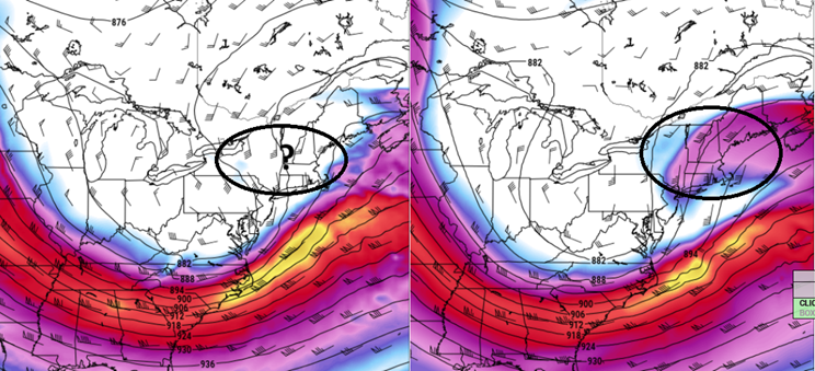
-
Feb 22nd/23rd "There's no way..." Storm Thread
Interstate replied to Maestrobjwa's topic in Mid Atlantic
THIS IS OUR STORM!!! -
Won’t be more than an hour of snow here before sleet . Maybe get an inch of sleet before zr ?
-

“Cory’s in NYC! Let’s HECS!” Feb. 22-24 Disco
Kitz Craver replied to TheSnowman's topic in New England
Beer. Looks like a positive trend to me. -

Feb 22nd/23rd "There's no way..." Storm Thread
ravensrule replied to Maestrobjwa's topic in Mid Atlantic
Are we looking at the same run?. -
Yes, we've been NAM-ed. Huge to see even if it's a bit out of its range (the important changes were mostly earlier).

.png.7854e9a896fa7cdf5569d5d5ac2dd9b7.png)

(002).thumb.png.6e3d9d46bca5fe41aab7a74871dd8af8.png)


