All Activity
- Past hour
-
meanwhile the girlfriend..
-
I love how it tracks to my west yet the heaviest precip goes to the east.
-
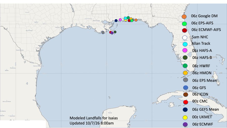
I like 50-75 miles east of there similar to Google. The 12Z GFS and ICON moved east.
-
Landfall right along the FL/AL line seems like the best bet right now
-
@Carvers Gap I'm very sorry for your loss. Yeah both my parents have graduated to be with the Lord. However I still miss them every day. Gonna be a long road for you and family. Thinking of you and praying for your peace at this time. Yeah I remember my first weather radio was a clunky box. I believe I lost my second radio on top of a payphone during a storm chase about 30 years ago. Probably a few maps too. At least I've never lost an expensive camera that way! ECMWF monthly clusters break down between cold, and quite mild. I lean toward the latter, but we can hope for the former.
-
Ike in 2008. Wasn't used in 2014
-

E PA/NJ/DE Autumn 2026 Obs/Discussion
Mikeymac5306 replied to PhiEaglesfan712's topic in Philadelphia Region
Someone brought this up either in the Tropical Forum, or MA Forum. It could be either it was 2020 and there was all the crap going on and it got overlooked, or they don't have enough "I" names to retire one. -
Forgot this whole subform existed till now! Though the recon this morning showed a weaker storm than expected based on IR presentation, it also appears to be on it's way to vertical alignment of its low levels with the convection flares now surrounding the center. Will be very interesting to see if the next recon flight shows strengthening as it flies through the storm; if it does, then we might be setting up for a bout of rapid intensification overnight as I believe that is the best window in terms of wind shear (and diurnal max).
-
I think the worst is Sat. after the game but I expect there to be upslope showers by kickoff at App. I think the escarpment gets 4-6 easily from this maybe more. We should be able to handle that with the antecedent conditions being fairly dry. Anything more than 8 and its trouble.
-
Bad news. Judah Cohen says that the slow rate of Siberian snowcover advance in the (*checks notes*) FIRST SIX DAYS OF OCTOBER implies a mild winter.
-
Low of 39
-
Okay I didn’t know this. I feel like I had never heard that name before but maybe it replaced a retired name?
-
lol why is the NHC in love with the name Isaias?
-

2026-2027 Record-breaking El Nino
forkyfork replied to Stormchaserchuck1's topic in Weather Forecasting and Discussion
maybe you should get it printed on a teddy bear and cuddle it to sleep every night <3 -
I’m sure there’s someone out there that would take that deal We let each other be ourselves. That works well most of the time. Looks like we have a center reformation ongoing. A vertically aligned system substantially increases RI odds.
-

E PA/NJ/DE Autumn 2026 Obs/Discussion
JTA66 replied to PhiEaglesfan712's topic in Philadelphia Region
I'm mildly surprised they didn't retire the name "Isaias", that was quite an impactful storm. Anyway... Bottomed out at 40F yesterday morning and 39F this morning. -
2026-2027 Record-breaking El Nino
forkyfork replied to Stormchaserchuck1's topic in Weather Forecasting and Discussion
did that 20cm shade of apocalyptic blue give you a wx hardon -
Will caution those who loves the latest CANSIPS pattern. While it looks good for storm track, the heights rising off the East coast give me some pause as we've been burned by a good NAO high pressure linking with the southeastern ridge. Additionally, with temperature anomalies in the Gulf stream being several degrees above average I wonder if the models may underestimate the southeastern ridge. Of course, too far out to draw any real conclusions, but I might favor a further west track than the H5 alone would suggest. Think it might be a big year for the mountains, especially the ridges that will be a few (possibly key) degrees colder. Also think @mitchnick's theory that it will be winter where we might have to be patient and watch a lot of rainstorms that slowly pull the boundary south before we get a limited window to get a follow up wave. That said, I could see a @psuhoffman nightmare situation where we see the boundary be pushed south before getting a perfect track rainstorm with snow confined solely to the high mountains due to just not having enough cold air. By the end of October we should have a better picture as the October NAO negative correlation to winter's NAO is our first real significant one.
-

2026-2027 Record-breaking El Nino
mitchnick replied to Stormchaserchuck1's topic in Weather Forecasting and Discussion
Apparently you did. -
Agreed, it does meet the NWS definition of first frost (low of 36-32) so that's how it goes down in my books. I also track the much more subjective first visible frost, still waiting to log that for me. My average First Frost date is 10/12 so a little early this year.
- Today
-
34.7 for the low here. Some frost on the rooftops and grass, first of the season.
-
a low of 38
-
I saw a couple yards on the way into work with some light frost on the lawns but that was it.
-
 https://antibiodirect.shop/# prescribed antibiotics online
 -
PSEG really went to work in my neighborhood after Isaias and some other wind events and trimmed a lot of branches near wires so thankfully in this last storm I just had power flicker a couple times but was good. A few streets away though where they didn’t trim had no power for 2.5 days.