All Activity
- Past hour
-
Thank you!
-

2025-2026 ENSO
so_whats_happening replied to 40/70 Benchmark's topic in Weather Forecasting and Discussion
Lol im not sure I understand this idea of his that the Caribbean can not foster a storm until it hits global mean average. Beryl came through early in the season (early July) but the next storm didn't form in the Caribbean (west) until Helene which was in the 3rd week of September. The SSTs were on fire last year but that did not dictate if the Caribbean would produce a storm. If the environment leading into the Caribbean was a little less hostile we would see a storm be able to do just as Beryl did or Helene. Remove the shear currently in place, which seems likely in the coming days, and a decent system tries to roll through it will produce. I feel like we heard this last year that ACE could not hit above average too. Edit: Why does it also have to go through the Caribbean to be an active season. -

July 2025 Discussion-OBS - seasonable summer variability
bluewave replied to wdrag's topic in New York City Metro
Yes. -
2013 was low ACE for completely different atmospheric/SST reasons but yea this season looks very likely to be below average
-

July 2025 Obs/Disco ... possible historic month for heat
kdxken replied to Typhoon Tip's topic in New England
-
 Potency continues for two events... MAY? add up to an isolated 5" storm today by Sunday night along with damaging wind-power outages-local detours. Follow NWS warning products. SPC has a slight risk for SVR today and nothing for Sunday which (imo only) may be underplayed for NJ on Sunday.. WPC has marginal risk for FF this afternoon-evening, again Saturday night-Sunday. Today: Large low level lapse rates may make up for lack of deep instability in a 95-100F max temp environment this afternoon. Fairly progressive sewd moving event but PW around 2" suggests wet microbursts mainly 4P-8P Sunday: low pressure focuses lift Sunday in a potentially more widespread FF event, especially NJ-LI. While instability a little less, the convergence with PWAT almost 2.4" may more than compensate. Be alert traveling late today and Sunday and have alternate plans for delays. Note: There might be late Saturday afternoon heavy showers in north central NJ s of i80 but the real deal is Sunday midnight-3PM. I have not included Tuesday's severe potential---in another thread early next week if my assessment is correct.
 -

2025-2026 ENSO
PhiEaglesfan712 replied to 40/70 Benchmark's topic in Weather Forecasting and Discussion
Yeah, I like knew in mid-June this was going to be a low ACE season (and it's pretty funny this is happening on the 20th anniversary of the most active season ever). A 2013-type season with just TS/C1 storms is looking more and more likely with each passing day. -
July 2025 Obs/Disco ... possible historic month for heat
kdxken replied to Typhoon Tip's topic in New England
70° / 68° yuck. Looks like lthe last week of July is going to do some damage . - Today
-
Still sticking with my thoughts that this Atlantic hurricane season ends up with below normal ACE
-

July 2025 Obs/Disco ... possible historic month for heat
ineedsnow replied to Typhoon Tip's topic in New England
Went to water country yesterday.. it was hot but with the breeze it didn't feel that bad.. -

July 2025 Discussion-OBS - seasonable summer variability
Monty replied to wdrag's topic in New York City Metro
If he drives around, he had better have one hell of a data plan. -
Stopping by to give burns more love *fists up*
-
RIP Mr Burns. Always enjoyed your sense of humor and insight into things. You will be missed here and everywhere else you roamed.
-
2025-2026 ENSO
so_whats_happening replied to 40/70 Benchmark's topic in Weather Forecasting and Discussion
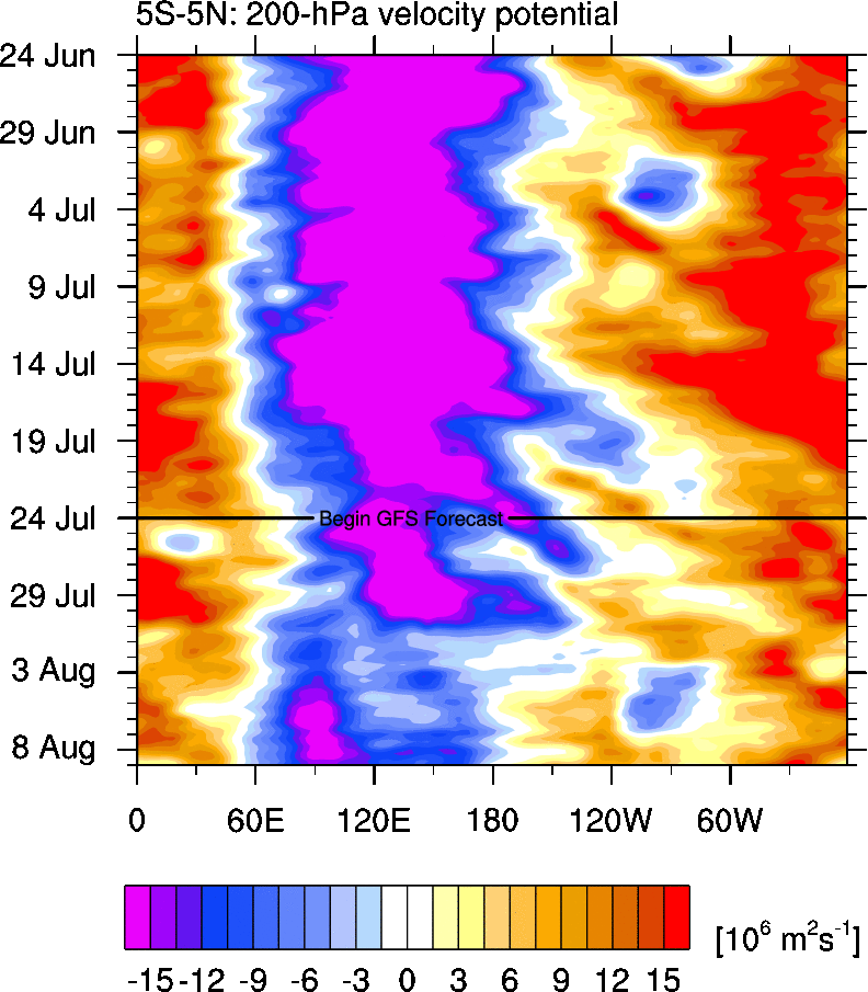
Have a feeling we may start to finally relax a bit on this -PDO pattern. Tropical storm and typhoon activity on the rise in the WPAC in fact the one ongoing system Krosa (I believe) looks to attain at least the equivalent of a cat 2-3 going over some of the warmest water anomalies east of Japan before recurving and going extra tropical creating a large wind field for this time of year as it nears the Aleutians. We will have to see if this continues because a one and done will not do the trick. I do not expect the PDO to completely flatline from this but we are starting to see signs of a shakeup in the continual ridge setup that has been around east of Japan. The cold tongue off Baja and California is also starting to neutral out if not go slightly above average as we go into August. Forcing also weakening up a bit around the Maritime continent and pushing closer to the dateline more often giving the MJO a 6-7-8 look. You can see the relaxing of +VP over the Atlantic coming up. Might even have a sneaky little system in the Atlantic to be on the lookout for as we head into August. While the pattern is not conducive right now it is also changing with time so we need to watch for any type of systems that make it to the eastern Caribbean islands in the next week.
-
 Post your forecasts for August below ... this post will eventually be edited to contain the updated annual scoring. The July scoring, already estimated above, will be finalized. Note that the July estimates are generally very high, and depending on how the final numbers fall, one or more scores could break the all-time record of 810.
 -
2025 through July 21st in N Hem had third lowest ACE for the date back to 1971 with it behind only 1977 and 1998.
-

2025 Atlantic Hurricane Season
WxWatcher007 replied to BarryStantonGBP's topic in Tropical Headquarters
I think we’re still going to end up AN on the numbers, but slightly so. I think it’s a more classic second half rather than what we saw last year, with activity centering mid September through mid October rather than the season extending into November. It’s a small window, but in that 4-5 week window I think that’s all we’ll need. -

July 2025 Discussion-OBS - seasonable summer variability
LongBeachSurfFreak replied to wdrag's topic in New York City Metro
I Live in you’re town. Do you drive around? During the last big rain event you referenced JFK getting 2”. There was a very sharp cutoff at the queens border. We received around an inch total. Since then nearly every convective event has missed. We are sitting in the 1.5” range for the last 30 days. That is in no way sufficient for peak solar insulation. This is a reoccurring theme the last few years. As we seem to rely on convection almost exclusively for summer rain. Our ecosystem developed with more spread out synoptic stratoform rains. Not just convection. The opinion posts are tiring and a big part of why myself and others post allot less here. I get it you love heat and hate rain in the summer. Move to fuking phoenix and be in you’re glory. -
July 2025 Discussion-OBS - seasonable summer variability
LongBeachSurfFreak replied to wdrag's topic in New York City Metro
I fixed it for you. Speak for you’re location. This area contains many micro climates. Parts of the east end of the island received .05” during the big New Jersey and lower Hudson Valley flood event. It’s like claiming a region was hit by a hurricane because of a micro burst. Something that is still open to interpretation with colonial weather observations. -

July 2025 Obs/Disco ... possible historic month for heat
weathafella replied to Typhoon Tip's topic in New England
Today was a garden variety warm day. Hit 90 at BOS but it was nothing like last week. Tomorrow may be hotter. -

July 2025 Obs/Disco ... possible historic month for heat
Snowedin replied to Typhoon Tip's topic in New England
Beautiful evening out there aside from a friendly neighborhood Fox screeching like a banshee trying to locate our crazy cat. That noise cuts right through everything! -
Praying Mantis eggs did wonders for our stink bug infestation years ago.
-
Saddened to hear about JBurns' passing. Time flies. May he rest in peace and may the family find peace during this time of grieving and reflection.
-
Guidance does show some sort of weak boundary crossing the area later Sunday. There isn't much change in air mass behind it, but it will likely increase storm chances Sunday. Hopefully, it will all wrap up by evening.
- 1,319 replies
-
- 1
-

-
- severe
- thunderstorms
- (and 2 more)
-

July 2025 Discussion-OBS - seasonable summer variability
psv88 replied to wdrag's topic in New York City Metro
85 at home today, was upper 70s and beautiful in Newport all week.