griteater
-
Posts
9,635 -
Joined
2 Followers

About griteater

Recent Profile Visitors
10,601 profile views


-
Saddened to hear about JBurns' passing. Time flies. May he rest in peace and may the family find peace during this time of grieving and reflection.
-
Amy Butler had some thoughts on the SSW evolution - https://x.com/DrAHButler/status/1745473686600142978?s=20
-
I believe he is referring to the ONI prediction contest from early September: https://www.americanwx.com/bb/topic/59534-what-strength-will-the-el-niño-peak-at-in-2023-2024/?do=findComment&comment=6992657 For Oct/Nov/Dec/Jan, I had: 1.8/2.0/2.0/1.9, Max tri-monthly in NDJ of 1.97 Actual for those months is: 1.72/2.02/2.07/? In reality, my thoughts on the peak have waffled here and there. After the flat-lining in September, I didn't think it would get quite as warm as it has
-
Your attacks on others are just pathetic, and you should be suspended for this kind of crap, and you've been doing it for years...not to mention the language you use that no one in this thread uses but you. On top of all that, you are accusing someone of something that isn't true. I'd like to see you do that to his face. I hope you are smart enough to realize that if you are making a seasonal forecast based off Strong El Nino and the PDO that there is a pretty small list of years to consider, so of course there are going to be similar ideas in forecasts. You need to be worrying about your own self and your own forecasts and quit attacking others.
-

Jan Medium/Long Range Disco: Winter is coming
griteater replied to stormtracker's topic in Mid Atlantic
Yeah I've been speculating in my head (dangerous) that this upcoming blocking period mid-late Jan may be the best part of the winter. I have concerns that when the MJO swings back around by early Feb that it will combine with +AAM and overcharge the Pac jet again and you get that sort of east-based nino look like the weeklies are showing there. That's a long ways off, but been pondering that. I think this -NAO episode mid-Jan is going to be a good one though. -
A visual of that from last night's 00z GFS
-
My guess is that they are from StormVista. He went on to say that he added the "60-90N" and "zonal wind anomaly" text in the title but stated that it should be "60N" and "zonal wind" instead. We'll have to see what it shows in the morning, but it looks like the regular Euro Ens (with 51 members) at 12z backed off some this run with the number of members with a SSW.
-
I think we can only get GEFS zonal wind data from the 00z runs
-
I think brooklyn was referring to the zonal wind chart that he ended up posting, which is based off today's Euro Weeklies (which is initialized from Dec 26 00z data)
-
Yeah that was surprising. It looks like today's 12z GFS bottomed out at +5 on Jan 8 http://www.weatheriscool.com/prod/ztemp_multilevels.html
-
Hopefully just a blip, but the 12z EPS had less SSW members this run.
-
Notable drop on tonight's GEFS Ext 00z run (10mb zonal winds)
-
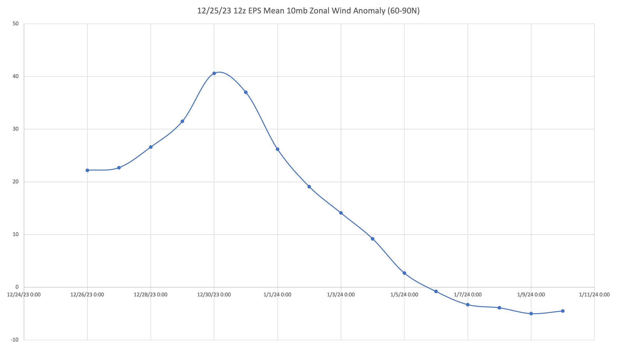
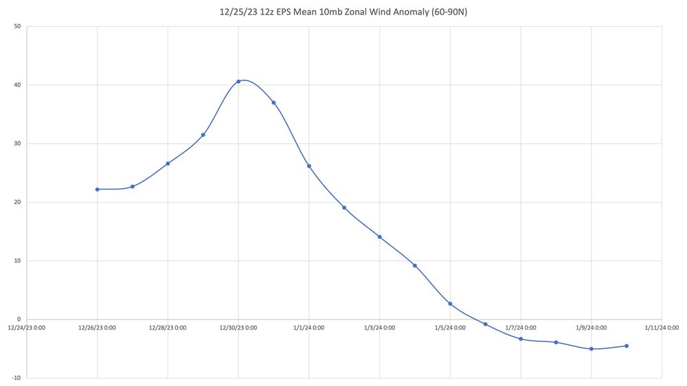
12z EPS Mean from Allan Huffman
-
Or like using the SREF model
-
Bias corrected version of yesterday's Euro Weeklies. 77% chance of SSW per yesterday's run. From Jan Dutton with World Climate Service (@jfd118)