All Activity
- Past hour
-

Major Hurricane Melissa - 892mb - 185mph at landfall
tamarack replied to GaWx's topic in Tropical Headquarters
True. The far longer lead time allows for 'cane chasers to find a safer spot. Josh picked the most solid-looking building at the north end of Great Abaco Island for Dorian and caught some amazing video of the front end. That "solid" building was badly damaged, and he (and others in that building) relocated during the eye. Tornado chasers are usually in vehicles and have minutes, or even seconds, to choose their spots. -
Working in the yard the last few days and the top soil is dust. Bone dry. October rainfall to date at my location is 1.56". That is FAR better than last October when the entire month had just a Trace. Still need rain badly. Think reasonable expectation for my area is 1" from the coming event based on current guidance. Anything more will be a gift and anything less will be a disappointment.
-
 Working in the yard the last few days and the top soil is dust. Bone dry. October rainfall to date at my location is 1.56". That is FAR better than last October when the entire month had just a Trace. Still need rain badly. Think reasonable expectation for my area is 1" from the coming event based on current guidance. Anything more will be a gift and anything less will be a disappointment.
- 19 replies
-
- 1
-

-
- heavy rain
- damaging wind? squalls?
- (and 2 more)
-

Major Hurricane Melissa - 892mb - 185mph at landfall
str8liner replied to GaWx's topic in Tropical Headquarters
She is not a big fan of vacuum cleaning Jamaica it appears. Much happier vacuuming the ocean. -

Major Hurricane Melissa - 892mb - 185mph at landfall
WolfStock1 replied to GaWx's topic in Tropical Headquarters
Well - Mitch made landfall with 80 mph winds; Melissa of course was over double that. Orders of magnitude more damage from 180 mph wind. -

Major Hurricane Melissa - 892mb - 185mph at landfall
Normandy Ho replied to GaWx's topic in Tropical Headquarters
This. The main difference between them is size -

Major Hurricane Melissa - 892mb - 185mph at landfall
CAPE replied to GaWx's topic in Tropical Headquarters
You're on the right track, I think. Both tornados and hurricanes exhibit vorticity and wind(a vector quantity). The big difference is the scale, but at a given point the wind velocity is what it is in both cases. Now consider the vorticity and lift. Much of the extreme damage we see in a tornado results from the(straight line) wind at a point PLUS the very strong localized lift within the more localized vorticity- an intense localized suction vortex. This produces the forces we see in videos that dramatically rips off roofs and uproots trees while lifting the debris rapidly upwards. Tornados are more intense, or 'violent' in a much more localized area. -

Major Hurricane Melissa - 892mb - 185mph at landfall
GaWx replied to GaWx's topic in Tropical Headquarters
We’ll see. There has been video of catastrophic floodwaters coming off the mountains this afternoon in many places in Jamaica including Mandeville. Hurricane Mitch, the 2nd deadliest Atlantic basin hurricane on record, caused 11-18K fatalities, mainly from catastrophic flooding and landslides due to epic rainfall amounts. -
First day of the season the sweatshirt didn't come off the entire day outside while working. The wind was ripping at times here in the lowlands. This has been a beautiful stretch of fall weather.
-

Major Hurricane Melissa - 892mb - 185mph at landfall
CTWeatherFreak replied to GaWx's topic in Tropical Headquarters
She lost her eye -

Major Hurricane Melissa - 892mb - 185mph at landfall
klw replied to GaWx's topic in Tropical Headquarters
Cuban radar http://www.insmet.cu/asp/genesis.asp?TB0=PLANTILLAS&TB1=RADAR&TB2=../Radar/05Pilon/plnMAXw01a.gif -

Spooky Season (October Disco Thread)
powderfreak replied to Prismshine Productions's topic in New England
It’s kind of crazy this time of year with the low sun angle that the eastern slope ski trails can hold onto frost all day long. 4:15pm and still frosty.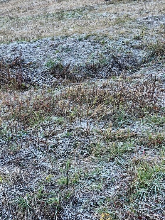
-
Major Hurricane Melissa - 892mb - 185mph at landfall
WolfStock1 replied to GaWx's topic in Tropical Headquarters
Here's the thing - I've driven through Chimney Rock, which was probably the worst-hit place, just a few months ago. Roughly half the downtown was wiped out. But generally that's about it; and it's a quite-small downtown actually. I have relatives that live right there in Lake Lure, and they - along with about 95% of the area - were relatively unaffected, aside from lost power, some downed trees, and some road washouts. The vast majority of structures were generally unaffected. You see the spectacular devastation of the areas hardest hit and assume that's the majority of places, but it's not; it's media selection bias. Contrast with the eye wall of a hurricane - of this force - which will wipe out almost everything; leaving almost no structure at least undamaged, and completely destroying a high percentage. Part of the reason I say that is due to the poverty of Jamaica - they just don't have the hurricane wind standards that the US does. (Just to reiterate - not trying to understate the fact that there will be massive rain-flood damage; I'm just asserting that I think the wind damage will likely be worse, along with the storm surge flooding.) Edit to add: the "wiped off the map" verbiage was mine - but I specifically qualified it with "large areas"; what I meant was for instance miles-wide swaths. In Chimney Rock's case, for instance, the swath was roughly 300-500 ft wide (you can see on google maps). Melissa's eye wall is about 300x that wide. -

Major Hurricane Melissa - 892mb - 185mph at landfall
WxWatcher007 replied to GaWx's topic in Tropical Headquarters
Ah, I was referring to radar for low level structure. It’s really hard getting regional radars. -

Major Hurricane Melissa - 892mb - 185mph at landfall
canderson replied to GaWx's topic in Tropical Headquarters
That’s due to the forming nor’easter -
 ESE flow ahead of a low tracking inland means lots of upslope for E PA/upstate NY and showery weather for the city/coast. Some places east of the low would get lucky with banding but by far the best would be well inland. Looking like a couple/few day nasty period without much drought help here. Thankfully we had the storm mid month to help a little.
 -
Yeah, a chilly day today with mid-50s, a breeze, and overcast.
-
Central PA Fall Discussions and Obs
canderson replied to ChescoWx's topic in Upstate New York/Pennsylvania
He’s quite east of me so I can see it. -

Major Hurricane Melissa - 892mb - 185mph at landfall
Brian5671 replied to GaWx's topic in Tropical Headquarters
Not related that's from a separate storm -

Major Hurricane Melissa - 892mb - 185mph at landfall
MonumentalNole replied to GaWx's topic in Tropical Headquarters
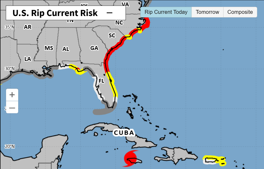
Is Melissa causing the current rip tide off the SE US coast from the other side of Cuba? Or is that due to other environmental factors and just a coincidence?
-

Major Hurricane Melissa - 892mb - 185mph at landfall
Torch Tiger replied to GaWx's topic in Tropical Headquarters
portion of a roof went off in that Reuters live feed! -
post what you want about what you want when the weather is slow and there's nothing to track, everyone else does
-

Major Hurricane Melissa - 892mb - 185mph at landfall
ineedsnow replied to GaWx's topic in Tropical Headquarters
Going to be interesting to see what she does in a few hours once back over the water -

Major Hurricane Melissa - 892mb - 185mph at landfall
Interstate replied to GaWx's topic in Tropical Headquarters
https://weather.cod.edu/satrad/?parms=subregional-W_Caribbean-15-48-1-100-1&checked=map&colorbar=undefined -
Thanks for making some of us feel extra old. (Are you sure he was your GREAT Grandfather?) Beautiful shot which probably looked the same in 1979. Very cool. BTW, had a major (MECS) snowfall that year.