All Activity
- Past hour
-

Possible Record Breaking Cold + Snow Sunday 1/25 - Tuesday 1/27
Franklin0529 replied to TriPol's topic in New York City Metro
January 96 an pd2 did -

Possible Record Breaking Cold + Snow Sunday 1/25 - Tuesday 1/27
nycwinter replied to TriPol's topic in New York City Metro
2010 christmas day after blizzard jan 2016 blizzard did not -

January 2026 regional war/obs/disco thread
mreaves replied to Baroclinic Zone's topic in New England
I would be happy with 3”-6”. We’ve been getting .5 every three day or so and it would be great to actually have to clear some snow. -

January 25/26 Jimbo Back Surgery Storm
LakeNormanStormin replied to Jimbo!'s topic in Southeastern States
Honestly, it questions the whole process. Is it a climate-related issue? Or a quirk in the algorithm? That's what I want to know. -
January 25-26 Winter Storm Potential
Franklin0529 replied to Ralph Wiggum's topic in Philadelphia Region
Not much further then what's being shown. The primary will die off an pop a coastal -

Winter 2025-26 Medium/Long Range Discussion
Snowstorms replied to michsnowfreak's topic in Lakes/Ohio Valley
Going to be whole lot of pingers on Fri-Sat with that pesky warm air aloft and how quickly it moves north. Won't be enjoying that. -
One thing that seems to be coming into hyper focus is that this is going to be a winter storm of proportions that our region as a whole hasn’t experienced in 10 years. I just hope it doesn’t end up being mostly sleet. I’d be perfectly fine with a huge thump of snow followed by sleet. I prefer all snow but it is what it is, and hopefully the trend doesn’t keep pushing.
-
The euro with the snow ice and sleet and severe cold will cause extreme hardship for the area
-
For me it's easier to swallow a mix when we get a foot+ of cold smoke right before and temps are in the teens for the duration.
-

January 2026 regional war/obs/disco thread
WxWatcher007 replied to Baroclinic Zone's topic in New England
I’d sign right now and lock this for all of New England. There’s a limit to far this can go, but much like the south a few hours ago and the Mid-Atlantic right now, I don’t want to be sitting here tomorrow at this time wondering how in the hell a historic Arctic outbreak leads to a coastal blasting the mix line 200 miles to my north. Not saying that’ll happen, but be careful of wanting others to sniff your backside… -
Power is overrated, there is a reason they make batteries.
-
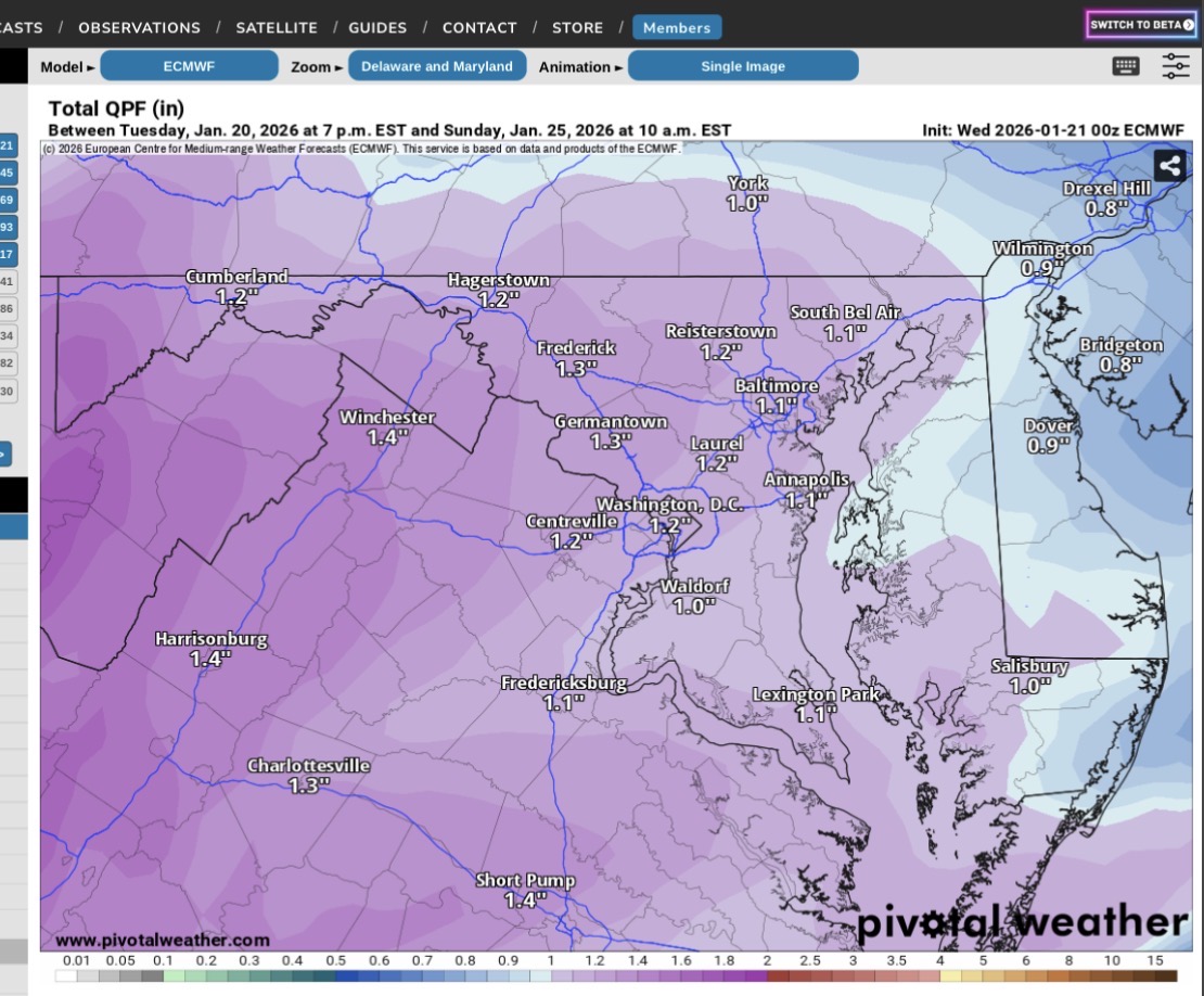
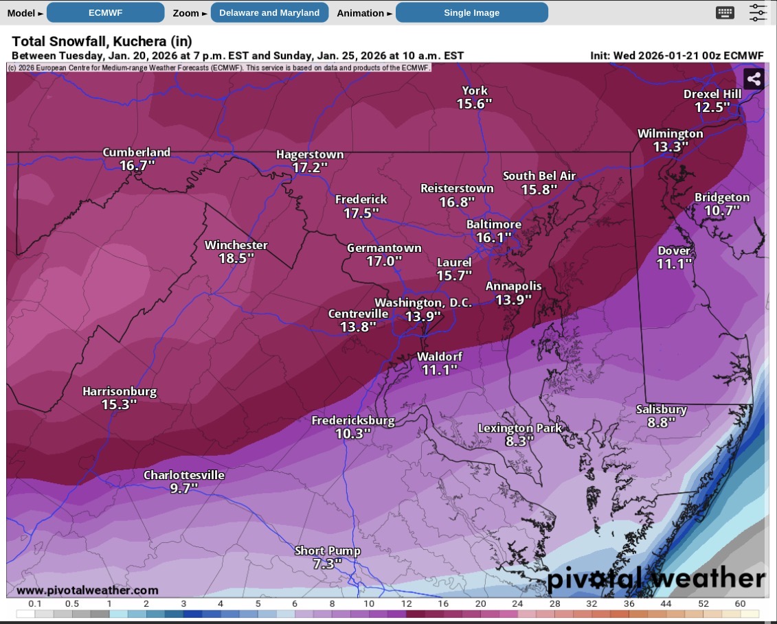
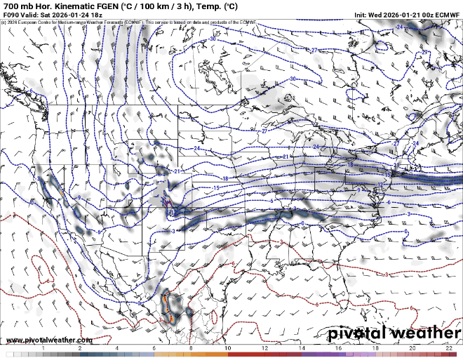
That front end thump is a straight ass kicking before any flip. 1-1.4” of precip, all snow before any flip to IP on the EC for any area west of the Bay. The 700mb FGEN are textbook on Pivotal as the WAA pattern moves in. A solid 10-18” falls before sleet comes into the picture, and the storm actually ends as snow to cap off any sleet. This is a really strong WAA pattern being depicted now with the phasing depiction. It will come in really hot and heavy like a wall. Still time for changes. This system can only climb so far north with the current upper level pattern as progged. QPF prior to flip Snow before flip 700mb FGEN
-
Will wait for EURO ensembles to come out and then get some sleep....
-
As someone who likes power I really hope we can avoid freezing rain with temps around 20
-
I just don't see how this one could come back at this point. It's not just one thing, but every single thing we need to trend our way going bad. Crazy model failure. Not just people falling for wild OP runs either. The ensembles were rock solid for a couple days.
-

January 25/26 Jimbo Back Surgery Storm
Silver Meteor replied to Jimbo!'s topic in Southeastern States
I used to enjoy YouTube weather channels until they became click bait central. Now they are insufferable, I avoid. -
I sleeted in Jan ‘16. Comes with the territory. I don’t want some boring ass .5 qpf bs where the ratio ends up 10:1 anyway. that being said, please stop going north.
-

Possible Record Breaking Cold + Snow Sunday 1/25 - Tuesday 1/27
SACRUS replied to TriPol's topic in New York City Metro
North with the 1 inch line -

Possible Record Breaking Cold + Snow Sunday 1/25 - Tuesday 1/27
NEG NAO replied to TriPol's topic in New York City Metro
agreed plus less QPF will mean colder temps and ratio's higher to compensate for less QPF -
SC. NC and VA guys
-
January 25/26 Jimbo Back Surgery Storm
LakeNormanStormin replied to Jimbo!'s topic in Southeastern States
Exactly. Trends become friends. Love them or hate them. I'm still in a bad space on that EURO. Enough freezing rain to f stuff up around here. -

Possible Record Breaking Cold + Snow Sunday 1/25 - Tuesday 1/27
allgame830 replied to TriPol's topic in New York City Metro
Could be just a minor over correction to the north. -
Plane sampled the Baja for 0z look what happened
-

January 25/26 Jimbo Back Surgery Storm
Thrasher Fan replied to Jimbo!'s topic in Southeastern States
The run to run consistency on the 0z EURO 114h is like throwing darts at a dart board blindfolded. Pull your hair out insanity. More fun tomorrow. -
Hey, whatever it works. I hope feeling normal and zen feels good. Nobody want's a mix, but I'm honestly still hyped for this...but this really has gotta stop right here, lol. It's a moisture bomb and we got cold for frozen.