All Activity
- Past hour
-
Today is October 3
-
I guess since it is not 90 we can't call it summer-like. Really worries me how we normalize the disappearance of our cold seasons. It is honestly why I cherish every single snow day. They are becoming so few and far between.
-
I'd say this would break a ton of records.
-

Spooky Season (October Disco Thread)
Cyclone-68 replied to Prismshine Productions's topic in New England
I apologize in advance but I figure somebody here would know. I’m traveling to Italy and Greece later this month. Any idea what kind of weather/climate to expect? -

Spooky Season (October Disco Thread)
Ginx snewx replied to Prismshine Productions's topic in New England
Cold will take hold when the rivers are bankful. November is going to be a very wet month. -
Time to build up the subscriber base for the winter. Like the squirrels gathering nuts.
-
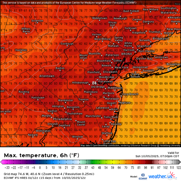
More summer-like than the Memorial Day weekend was. The Saturday to Monday highs were only in the upper 60s to mid 70s at the warm spots. The average high during that late May weekend is 75°. Models have 80°+ at the warm spots from Saturday through Tuesday. The average high this time of year is only 70°. Newark 2025-05-24 69 50 59.5 -6.0 5 0 0.02 0.0 0 2025-05-25 71 50 60.5 -5.3 4 0 T 0.0 0 2025-05-26 75 54 64.5 -1.6 0 0 0.00 0.0 0
-
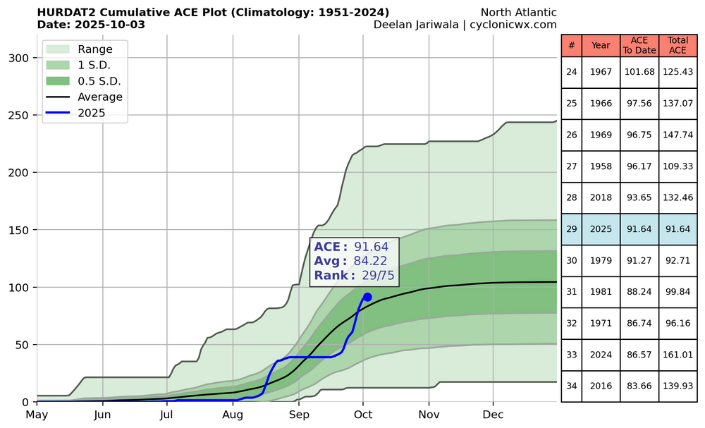
ACE, which yesterday got to a NN 91.64, is now taking a break for awhile pending mainly what the E MDR system and any possible W Caribbean system will or won’t do next week (Bahamas AOI is very weak with only a 10% chance): note that it got to 29th out of the last 75. It just missed 2018 though it went ahead of 2024, 2016, and 2022 (2022 not shown because it was then 78.85). But, 2024 and 2016 should soon pull well ahead of 2025 during this expected 2025 respite: So, getting 100+ is still not yet certain even though it’s highly likely. I’ll give it a 95% chance since it’s La Nina and recent late seasons have been active.
-

-

Spooky Season (October Disco Thread)
CoastalWx replied to Prismshine Productions's topic in New England
- Today
-
Yeah. There were upper 80s days. But no 90 since Sept 2018. Im ready for cooler weather but a milder Fall in La Nina is normal.
-
I remember that. We had no power either, so no heat too!
-
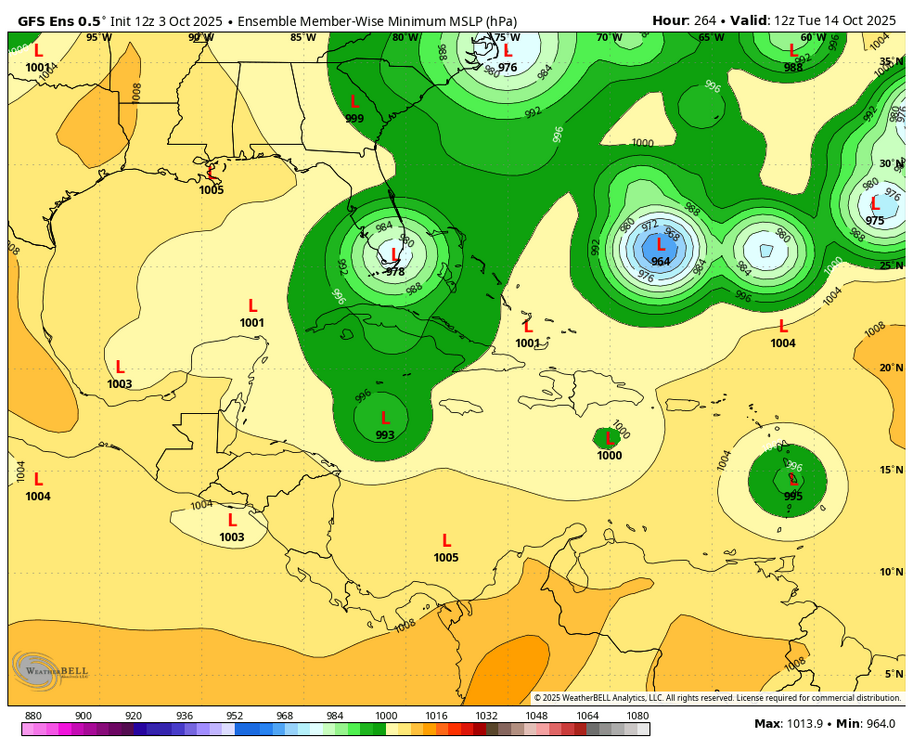
12Z GEFS for pumpkin: only one of 30 hits Conus (hits S FL as a hurricane) and that’s because it is the furthest SW member (at Barbados) as it approaches the Lesser Antilles. The rest are at that time from PR to the Leewards (~50%) with ~50% at that time well NE of the Leewards: Here’s when that one member hits S FL. The one at the Outer Banks is from a NW Caribbean system: Edit: I don’t think any 12Z EPS are hitting the CONUS. If there are any, I can’t tell.
-
Forgot to post this from the other day, but WPC winter desk OPEN FOR BUSINESS
-
The 12Z Euro for the “pumpkin”: no TC til ~192 hours when it’s 1005 mb that’s ~125 miles N of PR. But it’s already recurving sharply then and never gets stronger than 1005 mb til it gets to 30N way out in the middle of the ocean. ———— 2PM TWO up to 0/50:2. Tropical Atlantic:A tropical wave has just emerged off the coast of Africa. The wave is forecast to interact with another disturbance over the eastern tropical Atlantic, and then move westward after that. Environmental conditions are expected to become conducive for some slow development of the system in a few days, and a tropical depression could form near or east of the Lesser Antilles by the end of next week.* Formation chance through 48 hours...low...near 0 percent.* Formation chance through 7 days...medium...50 percent.Forecaster Berg
-
Back to 73 / 48
-

Mid to long range discussion- 2025
WinstonSalemArlington replied to wncsnow's topic in Southeastern States
CPC is hinting at a potential series of CAD events on their 3-4 week outlook -
Ended up making it down to a cold 41 this morning. Their are a lot of posting about the warmth coming and never-ending summer. I think we will warm up but I don't think we torch. The pattern has been volatile past day 5 so im taking the Cansips and the Euro Weeklies with a grain of salt.
-

Spooky Season (October Disco Thread)
40/70 Benchmark replied to Prismshine Productions's topic in New England
Well played, sir. -
2025-2026 ENSO
40/70 Benchmark replied to 40/70 Benchmark's topic in Weather Forecasting and Discussion
TBH, I do the opposite...my final forecast compoisite will be derived from 1951-2010 climo, but I will label it as 1991-2020 in an effort to account for CC. I started doing that last year. -
The weather through Monday looks absolutely stunning. No other way to say it.
-
Regarding the pumpkin: 12Z UKMET: 3rd in a row with TCG from this; similar TCG to prior run but moves NW instead of WNW and thus ends up further N than prior run although not quite as far N as two runs ago; Also this one has it become declassified at 168: NEW TROPICAL CYCLONE FORECAST TO DEVELOP AFTER 126 HOURS FORECAST POSITION AT T+126 : 16.6N 54.6W LEAD CENTRAL MAXIMUM WIND VERIFYING TIME TIME POSITION PRESSURE (MB) SPEED (KNOTS) -------------- ---- -------- ------------- ------------- 0000UTC 09.10.2025 132 17.8N 56.3W 1009 36 1200UTC 09.10.2025 144 19.9N 59.3W 1010 30 0000UTC 10.10.2025 156 21.8N 61.2W 1009 29 1200UTC 10.10.2025 168 CEASED TRACKING
-
actually not that bad... +1-2 with near normal precip is something i'll take
-
Wow check out Mammoth. They did get snow last night, its 31 and snowing. https://www.mammothmountain.com/on-the-mountain/mammoth-webcam/main-lodge
-
Mid to long range discussion- 2025
WinstonSalemArlington replied to wncsnow's topic in Southeastern States
Frost on the pumpkin?