All Activity
- Past hour
-
So close, yet so far

-
Edit: actually maybe 7.3 officially, the 7.6 was at NWS office? Academic though. Hard to be disappointed about the relative “underperformance” with those numbers across the metro at our latitude. Especially knowing it was always gonna be a +/- 50 miles situation with the heaviest band.
-
Sister-in-law who lives in San Fransisco had her first kid a month ago and we are visiting them in early April. For their sake I’m hoping it’s 50s and rainy, but it’s the very end of the rainy season so a heat dome looks more likely. We have a place rented on the beach in Half Moon Bay, kids are gonna love the tide pools.
-
Once again, a tricky forecast to try nailing for LOT when models continue to shift areas of warning criteria snow in the NW areas. Although, selfishly, the most recent Euro would be insane for my area.

-
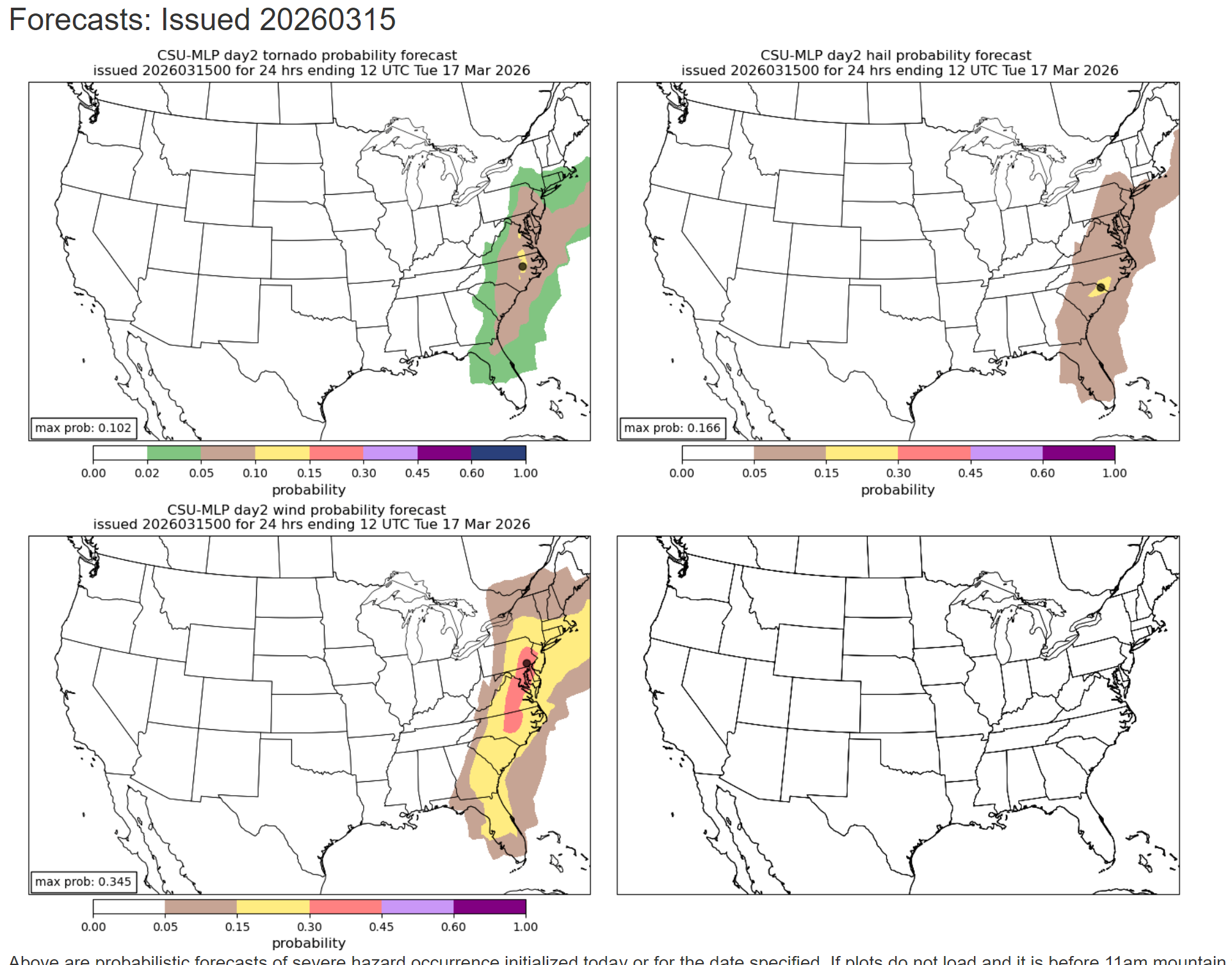
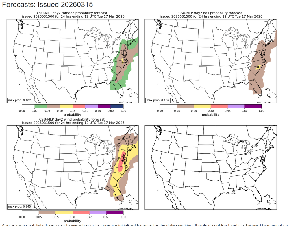
I’m interested to see how this plays out. I think this looks more realistic than the 60% wind. At least into Maryland maybe more impressive over central/eastern VA and NC. To me it doesn’t look all that impressive on models. I hope I’m right and we don’t get widespread wind damage. I don’t want to be without power for an unknown amount of time.
-
Will live or die by the overcast here today. A crap day or a decent day if there’s consistent breaks. It is very thin and sun beating through but still shrouded. In the east, we have a chance a mostly cloudy…we’ll see.
-
That jives with what I’m measuring 1-2mi north of the airport.
-
Ya I was kidding haha.
-
I noticed that too. Ground was not frozen. But I know earlier in Feb it definitely was. I think warmer temps and solar insolation even through the snow helps thaw.
-
Looks like 7.6” reported at MSP as of 7 am
-
CSU MLP mostly held steady with wind but maybe tailored back the TOR risk just a touch. I'm not entirely shocked - and I've been thinking even with some models showing pre-line cells, that this would be a wind dominated event with some brief QLCS spinnys. Nonetheless - I think SPC is hitting the threat level very well!
-
Hcubed does have 50-55 EOR and S of 90, but not as wild as NAMs. Ground here was thawed underneath the snow . It never really froze. Ground is somewhat firm especially in sunny areas
-
Wisdom ^^ What up fella? It's been a while. Welcome to our overanalysis discussion I think we need to rejigger our approach to grading as our world changes. I think of it like a dimmer switch. The earth says 'I'll tilt over this way and turn the lights down for a while, see what you can do with it'. 90 days or so later, the lights ease back on and bubbles of warm and cold struggle as it balances back out. Does a cold one land on your area? This one fired on all cylinders for a while, it delivered for those 90 days. You can make yourself nutty hyper analyzing and get to A-- or whatever. I'm giving it an A. Now it's time to move on to a groundwater maintaining spring where it rains a half inch, two days a week as the world leafs out.
-
It’s a beautiful morning in Durham, NC. The cherry blossoms are in full bloom at Duke Gardens, and the Duke University Blue Devils are ACC Football and ACC Basketball Champions (men and women). First time this has ever been accomplished in ACC history. What a beautiful day!
-
had a little thunder this morning as well. Temps hovering right below freezing but should hopefully jump up into the mid/upper 30s shortly.
-
Freshets…LFG
-
Sat: Today's record highs include Downtown LA at 92 degrees (previous 90 degrees in 2015), LAX at 88 degrees (previous 86 degrees in 1994), and UCLA at 89 degrees (previous 87 degrees in 2015)
-
Might have to check this out of its still around tomorrow 3.) How widespread heavy rainfall will be to cause minor flooding of rivers, streams and urban areas along with any ice jams causing issues with flooding. An ice jam on the Millers River in Athol, MA reported and photographed by a SKYWARN Spotter will be monitored for any flood potential if the heaviest rain develops in that area.
-
Going to wait until 12z models before I do my little write-up for my office. While a ton of people at work (including in management) read my emails - they seldom apply my messaging to their actual decision making - which I don't blame them since I'm a weather weenie. But so far it has burned them a few times (during snow events) when they've closed too late (once people were already at the office) or haven't closed early enough in the afternoon leading to people having 3-5 hour commutes. I've *never* seen them release early for something other than snow...And I'm physically onsite tomorrow until 5:30pm. Great....with no windows too!
-

Spring 2026 Pattern Discussion Thread
Holston_River_Rambler replied to Carvers Gap's topic in Tennessee Valley
Just woke up to see some of the hi-res were showing and I will take. Looks like the Nam is showing a 300mb jet acceleration that enhances lift behind the front: Precip. pops over central Alabama and Mississippi and ride up into eastern TN. I think there's probably more dynamically going on that that too, but I'm just excited to see what happens. Maybe we can get some tasty lapse rates with that March sun as the cold pools rolls through tomorrow PM? We'll see if we can get some good rates, but it has been pretty warm so I'd hedge against road problems in areas with lots of traffic especially. Also, just now logging back in, so I wanted to add sorry for your loss Daniel- 58 replies
-
- 1
-

-
- severe
- mountain snow
- (and 1 more)
-

2025-2026 ENSO
donsutherland1 replied to 40/70 Benchmark's topic in Weather Forecasting and Discussion
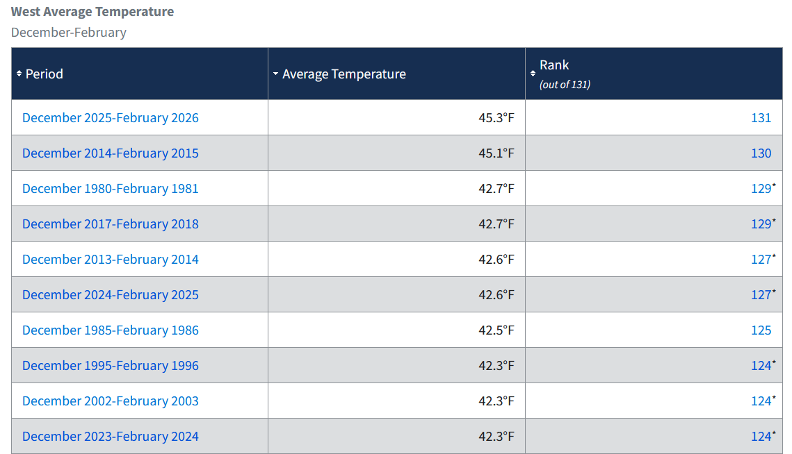
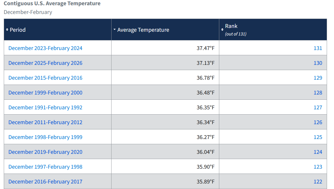
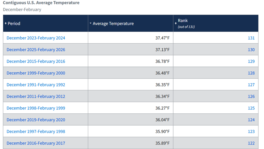
The last three winters have all ranked among the 10 warmest in the West: A disproportionate share of top 10 warm winters in the West and nationwide have occurred since 2000: The Great Lakes and Northeast were fortunate to have a cold and snowy (especially in the Northeast) winter. Such winters can still occur, and likely will occur for decades to come, but they have become notably less frequent on a nationwide basis.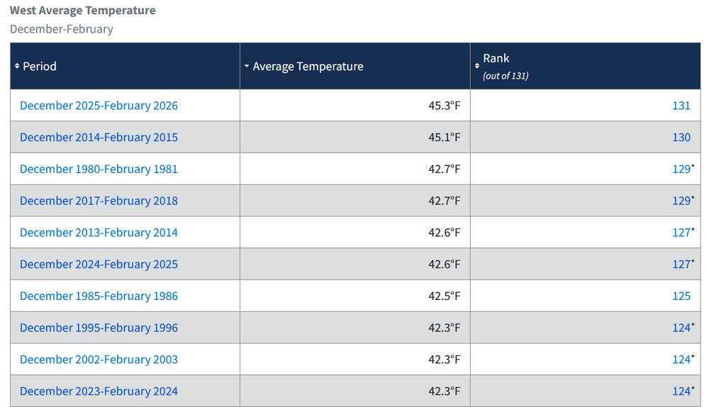
-
Thawing ground and S-SE flow could result in some Phil. I’d like to see some models other than the NAMs ramp it up though.
-

3/16/26 Severe Weather Event Thread (Day 2 MOD Risk)
dailylurker replied to Kmlwx's topic in Mid Atlantic
Urban chasing is tricky. I try to target areas where there's a less traffic but a good road system. Let use north Maryland for example. 70 is good for getting in but not for chasing an actual tornado. I chased out by Thurmont in Carroll County. Good roads, good views, and no traffic mayhem. You don't want to be stuck in traffic with an ef 3 tossing cars and coming at you. Watch for trees. I take my chainsaw just in case I need to cut my way out. Be careful and good luck. Btw. I'm not a met. I'm just nuts about weather lol. I'd join you if I wasn't working. -
Round 1 of shoveling I measured 7-8” depending on the spot. 12” storm total definitely still in play.
-
These always gust 50-55 EOR and especially with elevation. . 60 is magic number for those that want damage