All Activity
- Past hour
-
My daughter is a orthopedic PA. Tells me knee replacements are a piece of cake. She did a bunch last week actually. Not sure I trust her though. She's been angling for me to get my trick knee fixed. Good luck on your surgery!
-
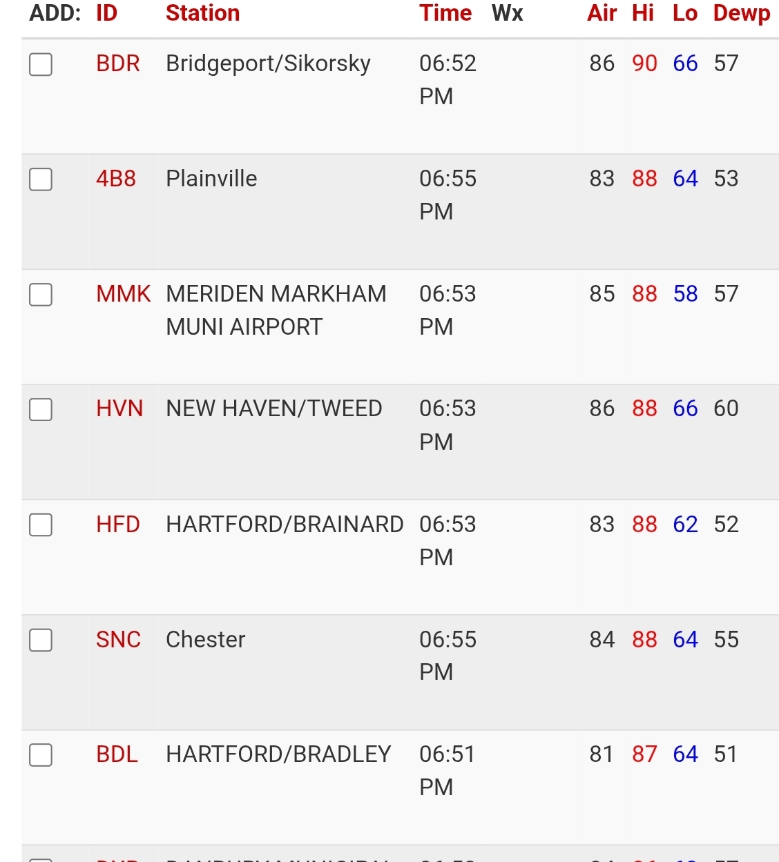
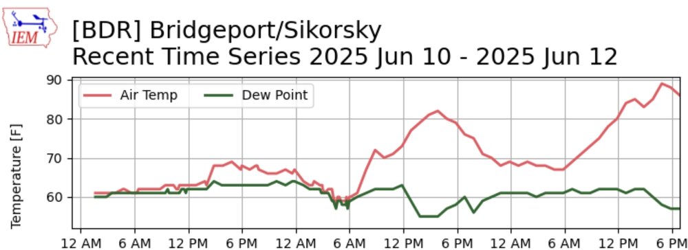
BDR with a nice late afternoon rally for their first 90 of the year.
-
Congratulations Mike!!
-

2025 Atlantic Hurricane Season
smokeybandit replied to BarryStantonGBP's topic in Tropical Headquarters
I'll be curious how those fare vs. traditional tropical models. -
Nice day for golf. Little smokey but workable.

-
Yep, this is a repeating pattern, the heat will return beginning next Wednesday with Thursday being peak heat again. It might be a carbon copy of today lol.
-
I'm pretty sure he wants rain for reasons that go beyond the scope of this weather forum section lol
-
Let it be a deluge on Saturday, I just want Father's Day to be nice.
-
Had a high temp of 92 here today. The fourth time that we've had a 90 degree high temp so far this season. We'll do it again late next week after the cool period this weekend into early week.
-
89.4. My first 90 will wait.
-
High ABV beers(9% +) brewed with a big grain bill tend to have complexity in the flavor profile. Nice aromas. That's what I mean by high food value. Big grain= more sugar= a higher alcohol content. The antithesis of a watered down, flavorless light beer. Gross lol.
-
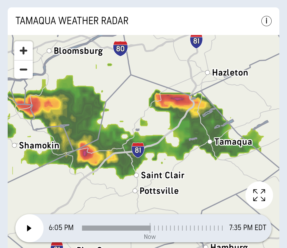
A few storms popping in eastern PA
-
you want the Mets game to be rained out?
-
This storm must have briefly had 1"-2" hail by Cheyenne and impressed storm chasers
-
good did not hit 90 today in the park did not feel that warm today i wore a light jacket..
-
I hope it pours Saturday
- Today
-
Hang on...chewy beer? High food value? Please explain for us alcohol illiterates (actually I may be one of the few on here, hahaha)
-
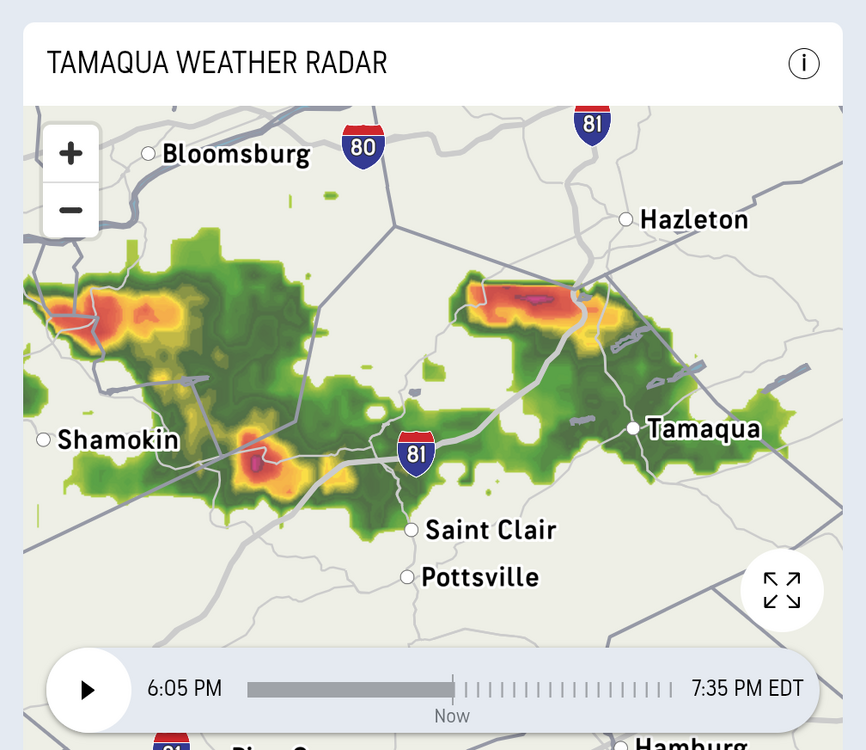
Actually, that storm north of Tamaqua is severe warned for 60 mph gusts and quarter sized hail. Severe Weather Statement National Weather Service State College PA 614 PM EDT Thu Jun 12 2025 PAC107-122230- /O.CON.KCTP.SV.W.0093.000000T0000Z-250612T2230Z/ Schuylkill PA- 614 PM EDT Thu Jun 12 2025 ...A SEVERE THUNDERSTORM WARNING REMAINS IN EFFECT UNTIL 630 PM EDT FOR NORTH CENTRAL SCHUYLKILL COUNTY... At 614 PM EDT, a severe thunderstorm was located over Mcadoo, moving east at 30 mph. HAZARD...60 mph wind gusts and quarter size hail. SOURCE...Radar indicated. IMPACT...Hail damage to vehicles is expected. Expect wind damage to roofs, siding, and trees. Locations impacted include... Mcadoo and Kelayres. This includes Interstate 81 from mile markers 137 to 138.
-
Storms of some kind of intensity getting close.
-

Central PA Summer 2025
Mount Joy Snowman replied to Voyager's topic in Upstate New York/Pennsylvania
Looks like MDT will fall just short of 90. -
The end of the 18z HRRR for Saturday afternoon DOES look a little interesting (yes fantasy range HRRR, I know... plus, verbatim, weak MLLRs and a saturated atmosphere in general limiting DCAPE). ETA: Others CAMs show hints of us being backdoored by a cool front by late Saturday.
-
No rain here yet, missed it by less than a mile. Media reporting RDU had it's hottest day of the year at 93. 91.4 at the house today, but yesterday was hottest for me at 92.7.
-
It's good to see JFK hotter than both, it dispels the rumors that this area is somehow *cool* in the summer. And JFK was actually slightly cooler than SW Nassau, we were well into the 90s here.
-
As usual for summer, KPIT fell short of expectations. 85 so far.
-
These big chewy beers with high food value give me such a pleasant buzz.