All Activity
- Past hour
-

July 2025 Discussion-OBS - seasonable summer variability
BxEngine replied to wdrag's topic in New York City Metro
The last time the hrrr was right was 1987 -
Despite running well ahead of normal with already 3 NS, the ACE through July 6th is still only at 1.46 vs the 1951-2024 avg of 4.12! That is lower than 46 of those 74 years. I’ll now compare to other years since 1951 with 3+ NS by July 6th along with their ACE: Year: NS/ACE 1954: 3/8.56 1959: 4/7.18 1968: 3/13.54 2005: 4/5.84 2012: 4/11.2 2016: 4/6.85 2017: 3/3.18 2020: 5/7.24 2021: 5/10.59 2023: 3/8.62 2024: 3/32.57 2025: 3/1.46 Note that for these 12 seasons since 1951 with 3+ NS by July 6th, the year 2025 has by far the lowest ACE/storm (0.49)! That easily beats the 2nd lowest, 2017’s 1.06/storm. The highest is 2024’s 10.86/storm. The avg of these 12 seasons through July 6th is ~2.8 ACE/storm.
-

Central PA Summer 2025
Mount Joy Snowman replied to Voyager's topic in Upstate New York/Pennsylvania
Getting back into the swing of things here after a splendid 4th of July weekend. Low of only 73, as humidity seems to be the name of the game this week. We've actually had some decent showers going here for most of the morning. It will be interesting to see who gets the big rain totals this week. -
It’s been raining lightly here for the last 45 minutes, and it looks like a plume of enough juice to keep it going off and on for awhile.
-
This happened in the middle of the night, the storms stalled out because there’s no trough nearby to expedite getting Barry’s remnants out, and the terrain/rock hard ground problem exacerbated it. It had zero to do with “weather modification”. I wasn’t paying enough attention to see if the NWS dropped the ball and the funding cuts are obviously a huge outrage and problem, but this is KNOWN to be a major problem in Central TX especially. There was 16” of rain in one morning in Austin from the remnants of Hurricane Patricia in Oct 2015 which is bar none the heaviest rain I’ve ever seen. Likely even puts Ida to shame. The Austin to San Antonio corridor is known to get tons of rain in a short period of time, but is otherwise pretty dry. And when it falls over the limestone Hill Country, it rampages down the hills into small creeks and as we see here, even the larger rivers can be overwhelmed fast.
-
The NWS has issued a flood watch for today and a heat advisory for tomorrow. There is a growing threat of flash flooding for some spots across the area. Forecast models have been a bit inconsistent on exactly where these will be so will be keeping an eye on those radars. We should remain warm and humid all week with the hottest day being tomorrow where some lower elevation spots may touch the low 90's. Ridge locations will likely fall just short of 90. We turn a bit cooler but still humid by the end of the week with temperatures a few degrees below normal during the afternoons but a few degrees above normal at night.
-

E PA/NJ/DE Summer 2025 Obs/Discussion
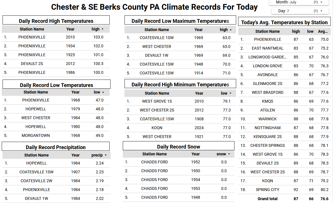
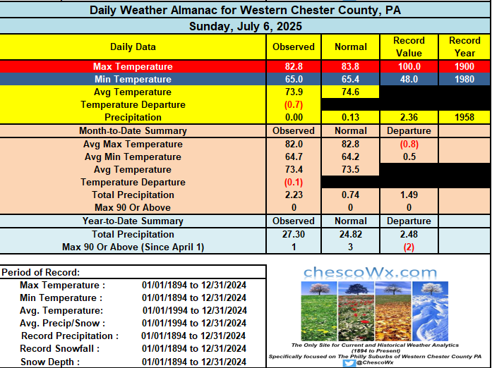
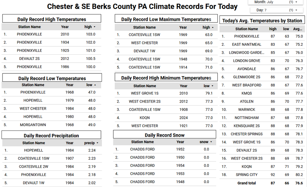
ChescoWx replied to Hurricane Agnes's topic in Philadelphia Region
The NWS has issued a flood watch for today and a heat advisory for tomorrow. There is a growing threat of flash flooding for some spots across the area. Forecast models have been a bit inconsistent on exactly where these will be so will be keeping an eye on those radars. We should remain warm and humid all week with the hottest day being tomorrow where some lower elevation spots may touch the low 90's. Ridge locations will likely fall just short of 90. We turn a bit cooler but still humid by the end of the week with temperatures a few degrees below normal during the afternoons but a few degrees above normal at night.
-
Back to having the feeling like rain is imminent only to have nothing to show for it.
-

July 2025 Obs/Disco ... possible historic month for heat
NoCORH4L replied to Typhoon Tip's topic in New England
Hoping for one of those types of storms today or tomorrow, minus the tragedy of course. Yeah 80 people, so sad. Keeps going up every time I look. -

July 2025 Discussion-OBS - seasonable summer variability
Stormlover74 replied to wdrag's topic in New York City Metro
Looks like there will be some storms training over the same area sw of nyc and down into pa (if hrrr is right)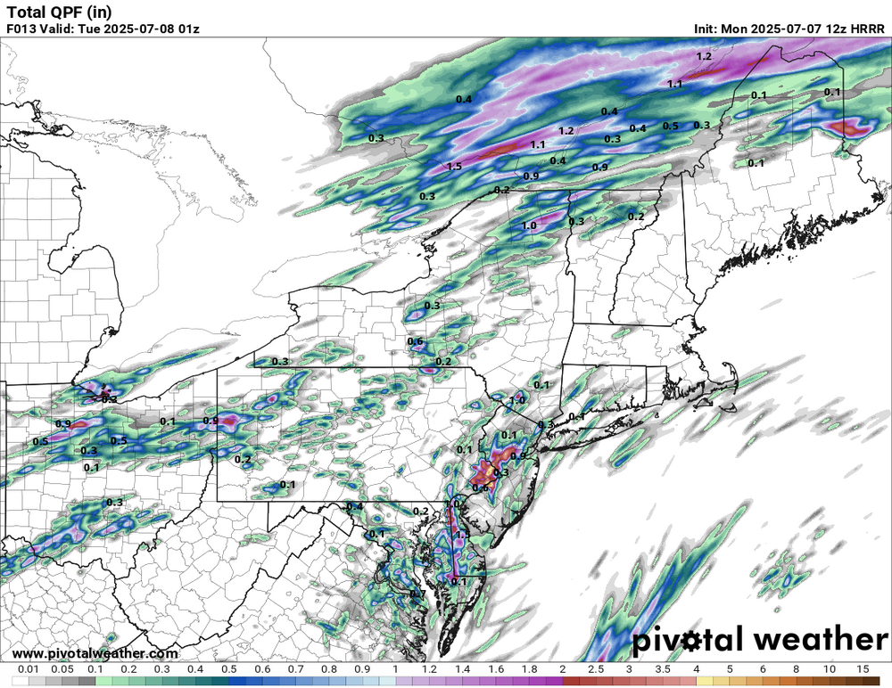
-

July 2025 Obs/Disco ... possible historic month for heat
weatherwiz replied to Typhoon Tip's topic in New England
Looking at some of those river gauges the rises were unimaginable...so many gauges that literally shot up like 20 feet in less than an hour. Absolutely horrific. - Today
-
July 2025 Discussion-OBS - seasonable summer variability
Stormlover74 replied to wdrag's topic in New York City Metro
79/74 with some sun. Steambath -
.thumb.png.4150b06c63a21f61052e47a612bf1818.png)
July 2025 Obs/Disco ... possible historic month for heat
HIPPYVALLEY replied to Typhoon Tip's topic in New England
Wow, I just saw that the death toll in that Texas flood is over 80 now. It’s crazy to have a death toll that high from flooding in a relatively small area. The water must’ve come in like a wall. -
Cape May, N.J. has the same dew point as Key West and Miami Beach currently at 78. Scanning up and down the East Coast 78 DP was the highest I could find presently.
-

July 2025 Discussion-OBS - seasonable summer variability
lee59 replied to wdrag's topic in New York City Metro
Showers coming off the ocean crossing Long Island, especially east. -

July 2025 Obs/Disco ... possible historic month for heat
Damage In Tolland replied to Typhoon Tip's topic in New England
Bad gas from last nights meal in a closed up room with no AC? -
July 2025 Obs/Disco ... possible historic month for heat
weatherwiz replied to Typhoon Tip's topic in New England
Flying down to Florida Thursday and going on a cruise from Saturday - Monday. Forget where it leaves from but going to the Bahamas...hoping to see thunderstorms from the boat or at least lightning in the distance at night. -
July 2025 Obs/Disco ... possible historic month for heat
weatherwiz replied to Typhoon Tip's topic in New England
WOW. Had that happened last summer. That was close! -
77.5/77.2 here in 21057 HRRR and NAM say no rain for me... but my point and click says 1/4 to 1/2 of an inch which is down from 3/4 to 1 inch in last night's forecast.
-
Dew point still increasing at 77 My dog has a hard time with this type of humid weather, even at 6:30 AM on our walk. Difficult to cool off.
-
I have no clue what the weather is going to do this week. One model has crazy rain. The next has nothing. It's hard to schedule work when the forecast is so iffy.
-

July 2025 Discussion-OBS - seasonable summer variability
winterwarlock replied to wdrag's topic in New York City Metro
Drizzling out..wtf -

July 2025 Obs/Disco ... possible historic month for heat
HoarfrostHubb replied to Typhoon Tip's topic in New England
Gross and foul air here this morning. Give me a repeat of yesterday please. -

July 2025 Obs/Disco ... possible historic month for heat
40/70 Benchmark replied to Typhoon Tip's topic in New England
Don't think so....bizarre way to celebrate summer- -
Sprinkler watch in effect for western zones.