All Activity
- Past hour
-
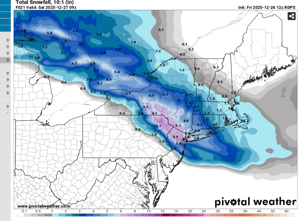
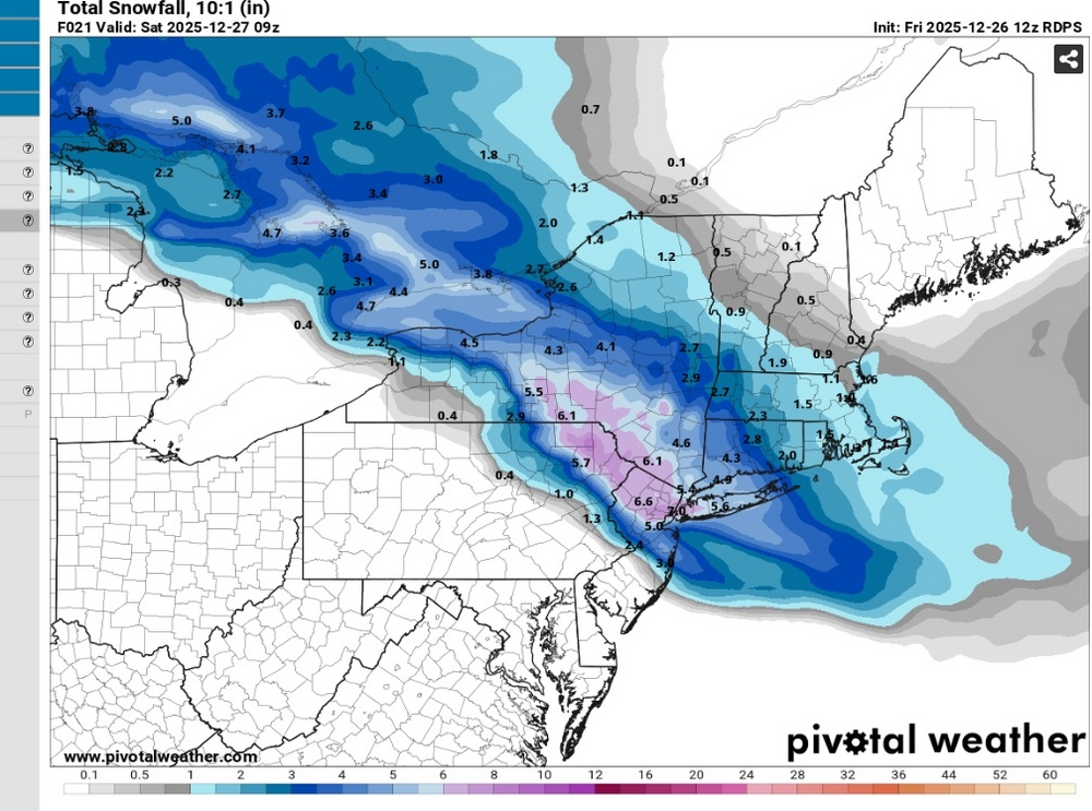
That is simply not true. Will some areas change over for a time as the precip lightens up? Maybe. NWS still has 6 inches or so for basically the entire NYC metro and they increased amounts slightly overnight. Are they just looking at snow maps also?
-
I'm doing the same thing. I usually go on Saturday, but pushing it to today because I don't want to go tomorrow after the shoveling and with roads likely being a mess.
-

Central PA Winter 25/26 Discussion and Obs
mitchnick replied to MAG5035's topic in Upstate New York/Pennsylvania
This system has reverted back to the old days of Niñas when the snow/freezing line slowly crept north as we got closer to the event. Unlike the snows in VA earlier in the month that never really bugged much at all from several days out. -
looks like some sleet/snow showers working their way thru VA.
-
My very casual looking the last couple days suggests next chance might be a clipper or some snow along an arctic front around NYD.
-

Central PA Winter 25/26 Discussion and Obs
Itstrainingtime replied to MAG5035's topic in Upstate New York/Pennsylvania
96 hours later - Itstrainingtime's house: 5.6" Mammoth Lakes, CA: 71" This is potentially good news for us as we want storm cycles to eject out of CA at our latitude as they begin their journey east. -
28F with light rain here. It's gonna be solid sheets of ice everywhere in no time.
-

26th-27th event, coming at us like a wounded duck.
Damage In Tolland replied to Go Kart Mozart's topic in New England
Not EB anymore. Last week I saw your car there so you know this -

Boxing Night Snow/Sleet/Ice Dec 26-27 Storm Thread/Obs.
LVblizzard replied to Mikeymac5306's topic in Philadelphia Region
I’m going with 1-3” for Allentown but it’s basically a crapshoot with how volatile that warm nose is. This is the type of storm where the airport sees nothing but sleet which barely accumulates an inch, while 20 miles away in Bangor they get 4-5”. -

26th-27th event, coming at us like a wounded duck.
weatherwiz replied to Go Kart Mozart's topic in New England
Electric Blue could get 7" and Kevin only 3" -
Need to go to shop rite. Wish me luck
-

26th-27th event, coming at us like a wounded duck.
Brian5671 replied to Go Kart Mozart's topic in New England
Agreed-will absorb most of it and turn it into a glacier once we go below freezing Monday nite. -

26th-27th event, coming at us like a wounded duck.
WinterSnow replied to Go Kart Mozart's topic in New England
Happy birthday to me! And we're still under a Winter Weather Advisory not a Warning? -

26th-27th event, coming at us like a wounded duck.
CoastalWx replied to Go Kart Mozart's topic in New England
Yeah Reggie came NE a tad. -
Yeah, that's a legit question. While things are still TBD, my answer is that in this case, it's not just low heights over AK, but the aleutian high is getting broken down with lower heights over the aleutians. This leads to a +PNA ridge over the west. If you animate that run from 300-360, you'll see the +PNA ridge building. Plus with that ridge, that extremely cold air over AK/Yukon will get shoved SE towards the eastern US albeit with some modification. Imagine instead if the aleutian high stayed, and the AK vortex helps dig a trough over the west, then yes that would be bad. But the models aren't showing that.
-
-
Looks about right to me. I could see it going a little further though and reaching SI/Brooklyn/JFK area. Can’t rule that out.
-

26th-27th event, coming at us like a wounded duck.
Baroclinic Zone replied to Go Kart Mozart's topic in New England
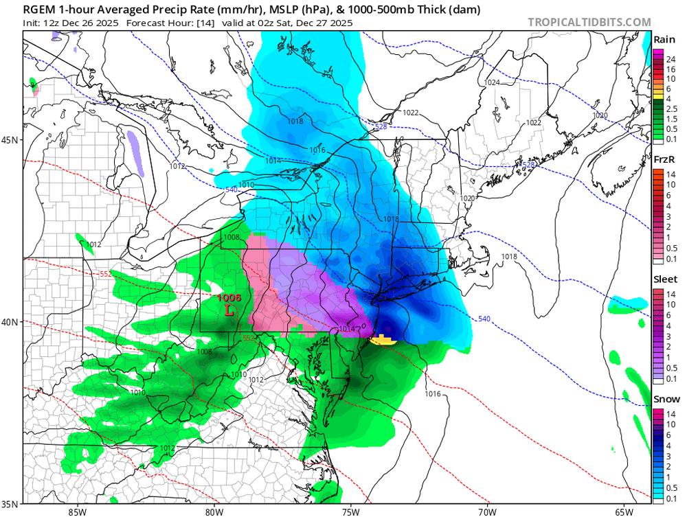
12z RGEM picking up on the coastal enhancement. Model run overall an improvement from 06z run. Not as robust QPF wise as other guidance. -

December 2025 regional war/obs/disco thread
WxWatcher007 replied to Torch Tiger's topic in New England
Still below zero here -
(002).thumb.png.6e3d9d46bca5fe41aab7a74871dd8af8.png)
Central PA Winter 25/26 Discussion and Obs
ChescoWx replied to MAG5035's topic in Upstate New York/Pennsylvania
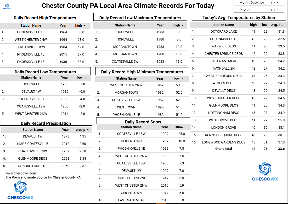
Our 6th winter event of the season arrives across the area late this afternoon and evening. We should see a brief period of snow followed by a longer period of accumulating sleet and ending early tomorrow as some freezing drizzle. Temperatures will remain well below freezing in most spots with highs in the middle and upper 20's. Road conditions will deteriorate rapidly this evening. We will stay cloudy and cold tomorrow with temperatures near freezing. Rain arrives on Sunday afternoon and lasts through much of Monday with much warmer temperatures on Monday. We turn sharply colder again on Monday night with temperatures remaining well below normal to close out 2025 and welcome in 2026.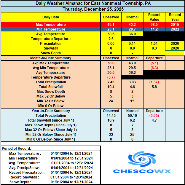
-
E PA/NJ/DE Winter 2025-26 Obs/Discussion
ChescoWx replied to LVblizzard's topic in Philadelphia Region
Our 6th winter event of the season arrives across the area late this afternoon and evening. We should see a brief period of snow followed by a longer period of accumulating sleet and ending early tomorrow as some freezing drizzle. Temperatures will remain well below freezing in most spots with highs in the middle and upper 20's. Road conditions will deteriorate rapidly this evening. We will stay cloudy and cold tomorrow with temperatures near freezing. Rain arrives on Sunday afternoon and lasts through much of Monday with much warmer temperatures on Monday. We turn sharply colder again on Monday night with temperatures remaining well below normal to close out 2025 and welcome in 2026.
-
Rgem looks mostly unchanged. The mix line surges and then stalls around a Nb to SMQ line
-
I don't think anyone would argue against a decent snowfall before a change over. Some here, as is tradition, are looking at snow maps and not soundings setting themselves up for disappointment.
-
December 2025 regional war/obs/disco thread
Damage In Tolland replied to Torch Tiger's topic in New England
Looks like a threat around the 31-1 timeframe -
Yeah even Central park had over 3” with that one. Lots of 3-5” across the island. NAM usually sniffs out the warm nose pretty well but it can overdo it at times