All Activity
- Past hour
-
And we have had 'help' in those domains in recent Nina winters. At this juncture I will be optimistic and side with persistence. I don't see any reason to think that won't be the case for at least a portion of the winter. The PDO? fuck it. It hasn't been favorable for years and we have still managed patterns that produced cold and some snow. I mean, fundamentally a -PDO is expected with cold ENSO. Historically that's how it works.
-
You know it's desperate when JB is limited to posts adding up the ACE points from last year.
-

September 2025 OBS-Discussion centered NYC subforum
donsutherland1 replied to wdrag's topic in New York City Metro
Tomorrow will be partly sunny with temperatures reaching the middle and upper 70s. The weekend will see a continuation of partly sunny skies with highs mainly in the middle and upper 70s. A few of the warmer spots could reach or exceed 80°. The next round of showers could be Monday. Temperatures will top out in the upper 70s to perhaps lower 80s on Monday and Tuesday. September 1-15 is on track to achieve a solid cool anomaly. Since 2000, there have been nine years that saw a cooler than normal first half of September. Two-thirds of those years went on to record a warmer than normal second half of September. Only two of those years (2017 and 2019) wound up with a monthly mean temperature of 70.0° or above. Overall, for two-thirds of those years, the cool start was sufficiently cool to produce a cooler than normal monthly anomaly. The last year that saw both a cooler than normal first half and second half of September was 2009. Prior to that, it was 2001. The last year to record a cooler than normal first half of September followed by a warmer than normal September was 2024. The ENSO Region 1+2 anomaly was -0.3°C and the Region 3.4 anomaly was -0.4°C for the week centered around August 27. For the past six weeks, the ENSO Region 1+2 anomaly has averaged +0.33°C and the ENSO Region 3.4 anomaly has averaged -0.32°C. La Niña conditions will likely develop during mid- or late-autumn. The SOI was -6.30 today. The preliminary Arctic Oscillation (AO) was +0.370 today. Based on sensitivity analysis applied to the latest guidance, there is an implied near 55% probability that New York City will have a cooler than normal September (1991-2020 normal). September will likely finish with a mean temperature near 68.7° (0.5° below normal). Supplemental Information: The projected mean would be 0.7° above the 1981-2010 normal monthly value. -

Central & Eastern Pacific Thread
Wannabehippie replied to Windspeed's topic in Tropical Headquarters
TD13-E has formed in eastern Pacific, just off the coast of Mexico. Predicted to head away from land, become a fish storm, peaking out around Sunday noon to Monday noon, weakening after that time. -
2025 Atlantic Hurricane Season
Wannabehippie replied to BarryStantonGBP's topic in Tropical Headquarters
Chances of formation are still low as per NHC. 0% in next 48 hours. 30% in next 7 days. - Today
-

2025-2026 ENSO
Stormchaserchuck1 replied to 40/70 Benchmark's topic in Weather Forecasting and Discussion
+PNA has high coastal low pressure correlation. So when we don't get that for many years people think that climate change is permanently changing the pattern lol. -EPO is very underrated just because of how flat central-North America is and a High pressure to the NW can really bring down cold air. +EPO isn't something we've seen much of lately. When it hits temperature forecasts almost always bust higher than expected. That's a pattern that when strong in January can lead to 70s in the Mid Atlantic. The Pacific definitely trumps the Atlantic as far as teleconnection patterns go, anomaly-wise, it goes more W->E vs N->S. -
Yeah, the real worry at this juncture is possible impending drought.
-
Yeah, some studies show that Correlation. Whether random coincidence or actual effect, probably not enough proof.
-
With a temp profile like that, the party in my view would be getting started . The multi-year trend of swinging from extremes continues with an incredible stretch ongoing of mainly sunny, dry, and pleasant temps also here. 10-day shows only 1 day of overcast! I don't buy it but I want to believe. The wx has been boring for so long. I was at the highest number of t-storms I've tracked in a year up til early Aug now nothing for a long time.
-
Yea, if that video is real he was dead right away.
-
2025-2026 ENSO
Stormchaserchuck1 replied to 40/70 Benchmark's topic in Weather Forecasting and Discussion
Yeah things aren't always what they seem. ENSO subsurface is cooling again with -4c in the central-region I found this correlates with the N. Pacific pattern most of all ENSO variables. The PNA correlation gets going in November, and has highest correlation in Jan-Feb.. if the cold water in the subsurface continues until then. Subsurface fluxes more than the surface. But we really haven't seen that much Aleutian ridging this year. With all the cold H5 near the Pole lately, a cold season +PNA is actually slightly favored just per the Summer Polar pattern. Will be interesting to see which of those two wins out this Winter. -

2025-2026 ENSO
Daniel Boone replied to 40/70 Benchmark's topic in Weather Forecasting and Discussion
Yeah, may turn out similar in several ways. -
2025-2026 ENSO
Daniel Boone replied to 40/70 Benchmark's topic in Weather Forecasting and Discussion
Yeah, quite the oddity. Couple years ago we had that weird shift with the QBO. Males for interesting research. -
12Z UKMET: another run with an MDR TS (this one moving WNW) from this wave: NEW TROPICAL CYCLONE FORECAST TO DEVELOP AFTER 84 HOURS FORECAST POSITION AT T+ 84 : 12.7N 32.7W LEAD CENTRAL MAXIMUM WIND VERIFYING TIME TIME POSITION PRESSURE (MB) SPEED (KNOTS) -------------- ---- -------- ------------- ------------- 0000UTC 15.09.2025 84 12.7N 32.7W 1010 27 1200UTC 15.09.2025 96 13.7N 35.4W 1008 29 0000UTC 16.09.2025 108 13.9N 37.7W 1006 28 1200UTC 16.09.2025 120 15.2N 39.8W 1005 38 0000UTC 17.09.2025 132 17.1N 41.3W 1004 40 1200UTC 17.09.2025 144 18.6N 43.3W 1003 42 0000UTC 18.09.2025 156 20.4N 44.8W 1003 45 1200UTC 18.09.2025 168 21.3N 46.7W 1003 41
-

September 2025 OBS-Discussion centered NYC subforum
SACRUS replied to wdrag's topic in New York City Metro
83 / 49 here - a gorgeous day. -

September 2025 OBS-Discussion centered NYC subforum
Sundog replied to wdrag's topic in New York City Metro
"Warmest winter on record" really looked like it was going to happen until that record PNA ridge unleashed the Arctic. -

Pittsburgh PA Fall 2025 Thread
TheClimateChanger replied to TheClimateChanger's topic in Upstate New York/Pennsylvania
-
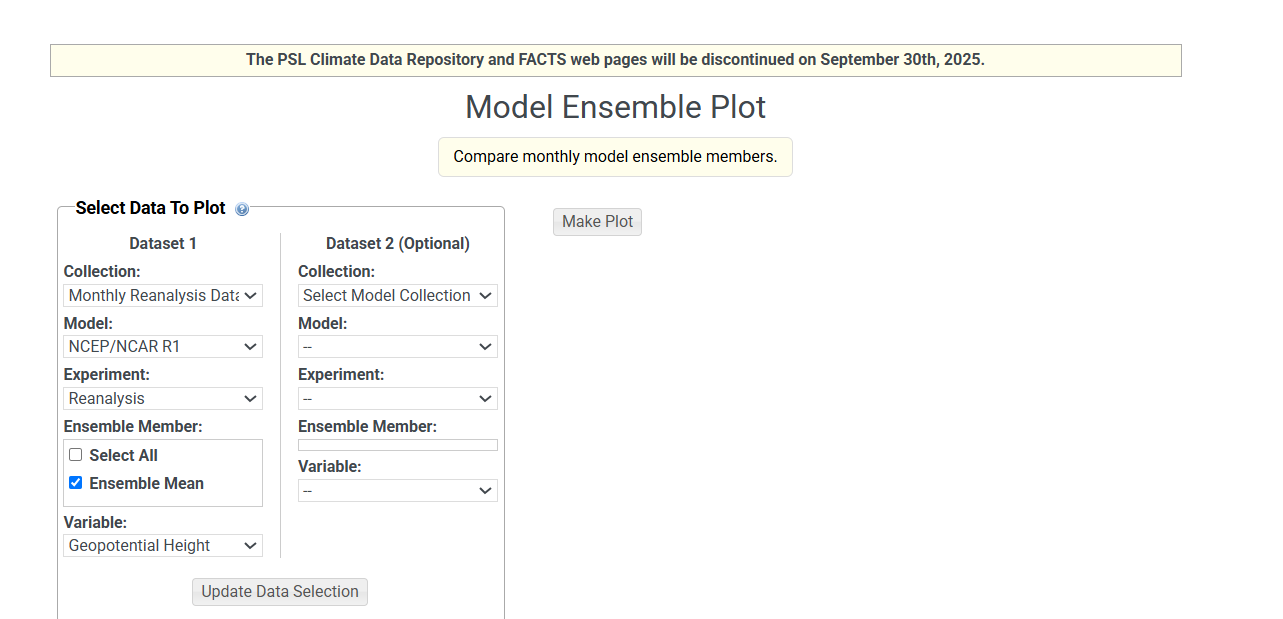
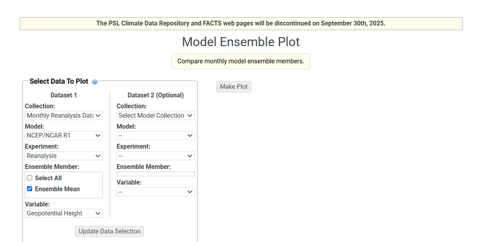
is there any other alternative that allows you to change climo periods and parse an unlimited amount of years?
-
September 2025 OBS-Discussion centered NYC subforum
donsutherland1 replied to wdrag's topic in New York City Metro
September 16-30, 2006 had a mean temperature of 66.6, which was slightly above even the 1991-2020 baseline for this period. -

2025-2026 ENSO
michsnowfreak replied to 40/70 Benchmark's topic in Weather Forecasting and Discussion
Everytime you guys bring up 95-96 I just cringe. I mean its 30 years ago and I was 12...and there have been many amazing winters since...but 95-96, just gross lol (except for the Mar 20 storm). -
@Itstrainingtime called it - feels like summer. 82 and pretty muggy.
-
Interesting how apparently 1828 was a super hot summer.
-

September 2025 OBS-Discussion centered NYC subforum
psv88 replied to wdrag's topic in New York City Metro
80 and sunny. Absolutely perfect weather -
-

September 2025 OBS-Discussion centered NYC subforum
Brian5671 replied to wdrag's topic in New York City Metro
A couple fall noreasters would wipe out that drought map...