All Activity
- Past hour
-
URGENT - WEATHER MESSAGE National Weather Service Baltimore MD/Washington DC 1207 PM EDT Sat May 2 2026 MDZ003>006-507-VAZ028>031-036>040-050-051-501-505-WVZ051>053-030015- /O.NEW.KLWX.FR.Y.0004.260503T0600Z-260503T1300Z/ Washington-Frederick-Carroll-Northern Baltimore-Northwest Harford- Frederick-Page-Warren-Clarke-Nelson-Albemarle-Greene-Madison- Rappahannock-Orange-Culpeper-Northern Fauquier-Western Loudoun- Morgan-Berkeley-Jefferson- 1207 PM EDT Sat May 2 2026 ...FROST ADVISORY IN EFFECT FROM 2 AM TO 9 AM EDT SUNDAY... * WHAT...Temperatures as low as 33 to 36 degrees will result in frost formation. * WHERE...Portions of north central and northern Maryland, central, northern, and northwest Virginia, and panhandle West Virginia. * WHEN...From 2 AM to 9 AM EDT Sunday. * IMPACTS...Frost could harm sensitive outdoor vegetation. Sensitive outdoor plants may be killed if left uncovered.
-
URGENT - WEATHER MESSAGE National Weather Service Baltimore MD/Washington DC 1207 PM EDT Sat May 2 2026 MDZ502-VAZ025>027-507-508-WVZ050-055-502-504-030015- /O.NEW.KLWX.FZ.W.0005.260503T0600Z-260503T1300Z/ Central and Eastern Allegany-Augusta-Rockingham-Shenandoah- Northern Virginia Blue Ridge-Central Virginia Blue Ridge- Hampshire-Hardy-Eastern Grant-Eastern Mineral- 1207 PM EDT Sat May 2 2026 ...FREEZE WARNING IN EFFECT FROM 2 AM TO 9 AM EDT SUNDAY... * WHAT...Sub-freezing temperatures as low as 30 degrees expected. * WHERE...In Maryland, Central and Eastern Allegany County. In Virginia, Central Virginia Blue Ridge, Northern Virginia Blue Ridge, Shenandoah, Augusta, and Rockingham Counties. In West Virginia, Eastern Grant, Eastern Mineral, Hampshire, and Hardy Counties. * WHEN...From 2 AM to 9 AM EDT Sunday. * IMPACTS...Frost and freeze conditions could kill crops, other sensitive vegetation and possibly damage unprotected outdoor plumbing. URGENT - WEATHER MESSAGE National Weather Service Baltimore MD/Washington DC 1207 PM EDT Sat May 2 2026 MDZ501-509-510-VAZ503-504-WVZ501-503-505-506-030015- /O.UPG.KLWX.FZ.A.0004.260503T0600Z-260503T1300Z/ /O.NEW.KLWX.FZ.W.0005.260503T0600Z-260503T1300Z/ Extreme Western Allegany-Western Garrett-Eastern Garrett-Western Highland-Eastern Highland-Western Grant-Western Mineral-Western Pendleton-Eastern Pendleton- 1207 PM EDT Sat May 2 2026 ...FREEZE WARNING IN EFFECT FROM 2 AM TO 9 AM EDT SUNDAY... * WHAT...Sub-freezing temperatures as low as 28 degrees expected. * WHERE...In Maryland, Eastern Garrett, Extreme Western Allegany, and Western Garrett Counties. In Virginia, Eastern Highland and Western Highland Counties. In West Virginia, Eastern Pendleton, Western Grant, Western Mineral, and Western Pendleton Counties. * WHEN...From 2 AM to 9 AM EDT Sunday. * IMPACTS...Frost and freeze conditions could kill crops, other sensitive vegetation and possibly damage unprotected outdoor plumbing.
-
We did this year.
-
Either way this weather has been great!
-

Occasional Thoughts on Climate Change
TheClimateChanger replied to donsutherland1's topic in Climate Change
-
Raw afternoon. Showers and bit of a breeze. Low 50s.
-
-
That’s a cutter . Way west
-
That was my hope also.. Hopefully we trend that one late in the week close to the coast and stronger.. maybe we get lucky
-
I want a summer chock full of derechos, supercells, tornados, and tropical storms
-
It’s as inevitable as the sun rise
-
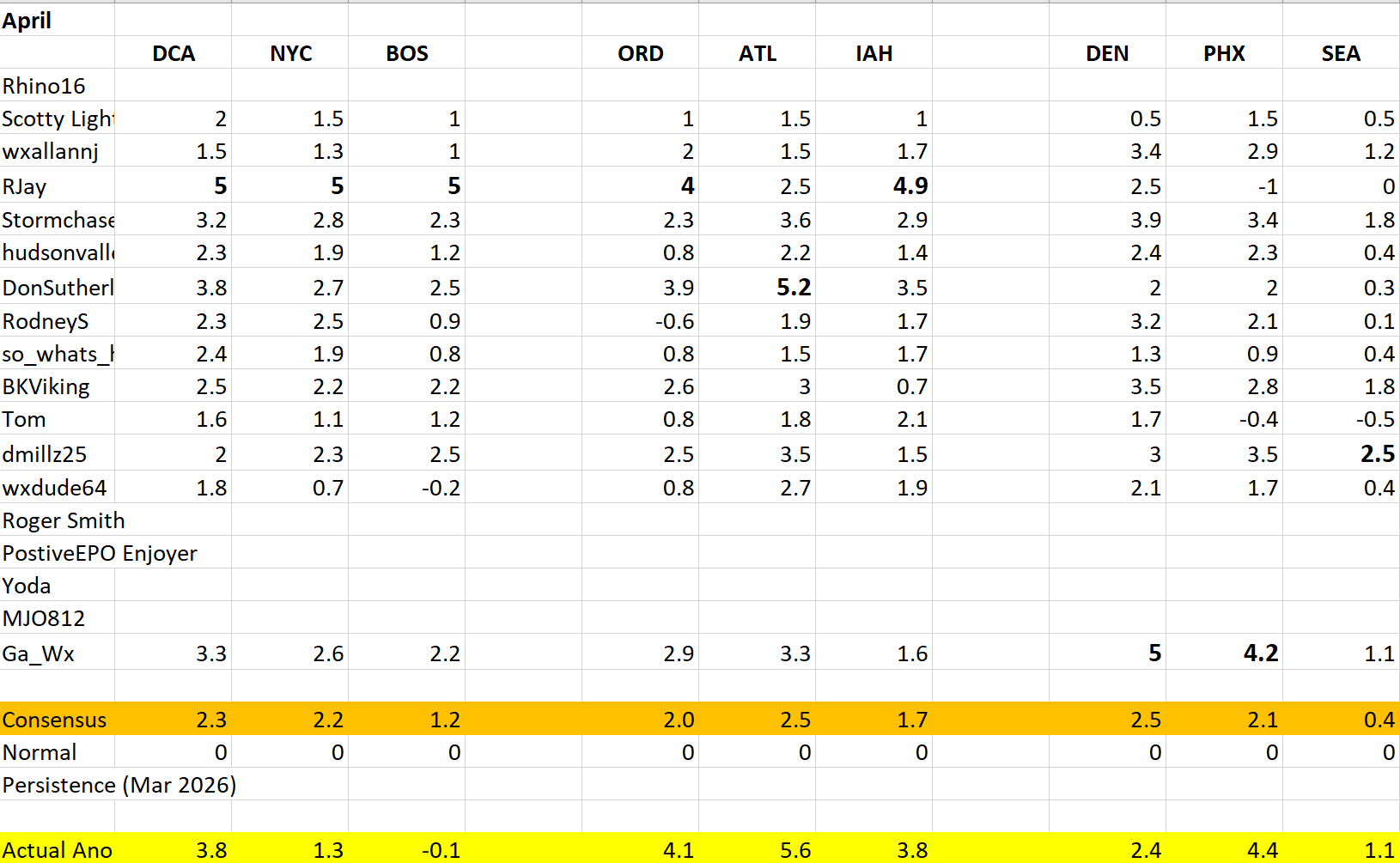
 Here is a recap of forecasts as well as what ended up being the actual anomalies for the month of April.
-
sucks we couldn't get the coastal to pass closer tonight .. could have been a late season snow for the higher elevations
-
Low 40s with light rain. Better to get this crud now than during fruit tree blossom time like last May - pollinators hiding and trying to stay warm.
- Today
-
Its been boring here,almost like 2022 where we only had 5 tornadoes the whole year,thats really surprising to me in 2022 it was mainly a moderate NINA the whole year
-

Fall/Winter Banter - Football, Basketball, Snowball?
KakashiHatake2000 replied to John1122's topic in Tennessee Valley
Don’t know where to post this but wowza check out the probability of above average snowfall during (super?) El Niño winter https://www.facebook.com/MikeLaniWeather/photos/%EF%B8%8Finteresting-map-from-ben-noll-showing-the-chances-of-above-average-snowfall-dur/1451308626797113/?set=a.558528376075147&http_ref=eyJ0cyI6MTc3Nzc1MTIwNTAwMCwiciI6Imh0dHBzOlwvXC93d3cuZmFjZWJvb2suY29tXC9zaGFyZVwvMUNmM0J0Y1FOa1wvP21pYmV4dGlkPXd3WElmciJ9 . -
If SPC Day 4-8 Outlook holds true, might see a few more post from me in the coming days.
-
WTF is with this weather. I’m getting tired of golfing in shit. 45 and rain.,50 but blowing 30.
-
Actually was decent this morning and hit 60 around noon. Cloudy 54° now Hoping we can salvage most of tomorrow and get some breaks
-
Plenty of breaks on visible
-
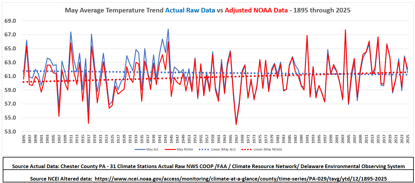
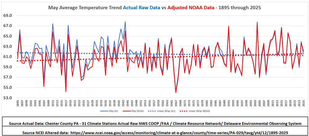
(002).thumb.png.6e3d9d46bca5fe41aab7a74871dd8af8.png) Below for the Philly burbs of Chester County PA are the all-time May climate records and below that the climate trends for the month. Based on the actual historical data (blue) our average May temperatures show a slight cooling trend since 1893 while the adjusted NCEI (red) temperatures indicate a very slight warming trendline.
Below for the Philly burbs of Chester County PA are the all-time May climate records and below that the climate trends for the month. Based on the actual historical data (blue) our average May temperatures show a slight cooling trend since 1893 while the adjusted NCEI (red) temperatures indicate a very slight warming trendline.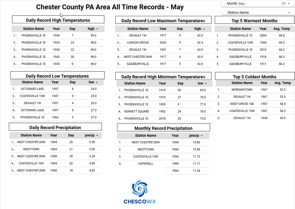
-
LOL!! but it is the only 134 years of data we have for this beautiful county of Chester....so we analyze!!!
-
Central PA Spring 2026 Discussion/Obs Thread
ChescoWx replied to Voyager's topic in Upstate New York/Pennsylvania
Below for the Philly burbs of Chester County PA are the all-time May climate records and below that the climate trends for the month. Based on the actual historical data (blue) our average May temperatures show a slight cooling trend since 1893 while the adjusted NCEI (red) temperatures indicate a very slight warming trendline.
-
E PA/NJ/DE Spring 2026 Obs/Discussion
ChescoWx replied to PhiEaglesfan712's topic in Philadelphia Region
Below for the Philly burbs of Chester County PA are the all-time May climate records and below that the climate trends for the month. Based on the actual historical data (blue) our average May temperatures show a slight cooling trend since 1893 while the adjusted NCEI (red) temperatures indicate a very slight warming trendline.
-

2026-2027 Strong El Nino
jaxjagman replied to Stormchaserchuck1's topic in Weather Forecasting and Discussion
It seems like it could level off for a brief time,the MJO is forecast to stay into the IO for a brief time but this seems like its from the Rossby Wave train into the IO with a Kelvin Wave moving towards the Peruvian coast,you can see this as 1.2 is starting to rise now from downwelling Kelvin Wave.Another big WWB seems to be coming past mid month somewhere along the IDL


.thumb.jpg.049f4a7f726ada07e8cd30bd17e713cb.jpg)


.thumb.gif.f92b16c631a1d15d405ed77b33f0710d.gif)