All Activity
- Past hour
-
I remember the only cold week that entire winter was the week leading up to the big storm. The day after the storm was the last cold day that winter. The week after the storm was in the 60's and it didn't really get cold again.
-

Pittsburgh/Western PA WINTER ‘25/‘26
Rd9108 replied to Burghblizz's topic in Upstate New York/Pennsylvania
Interesting graphic by the NWS. Seems like its all gonna depend on the banding.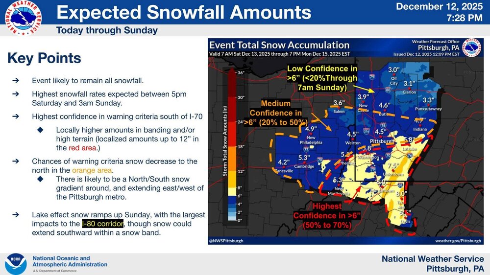
-
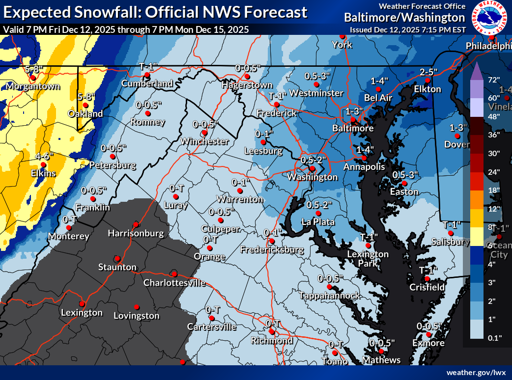
Latest from LWX:

-
that was a weird winter, but still good IMO. For NYC - biggest snowstorm in history plus the last time Central Park got below zero. Still warm, yes, but those events save it IMO.
-
Eskimo Joe is a sick human being lol
-
Saturday night/Sunday 12/13-12/14 Jawn
simbasad2 replied to Ralph Wiggum's topic in Philadelphia Region
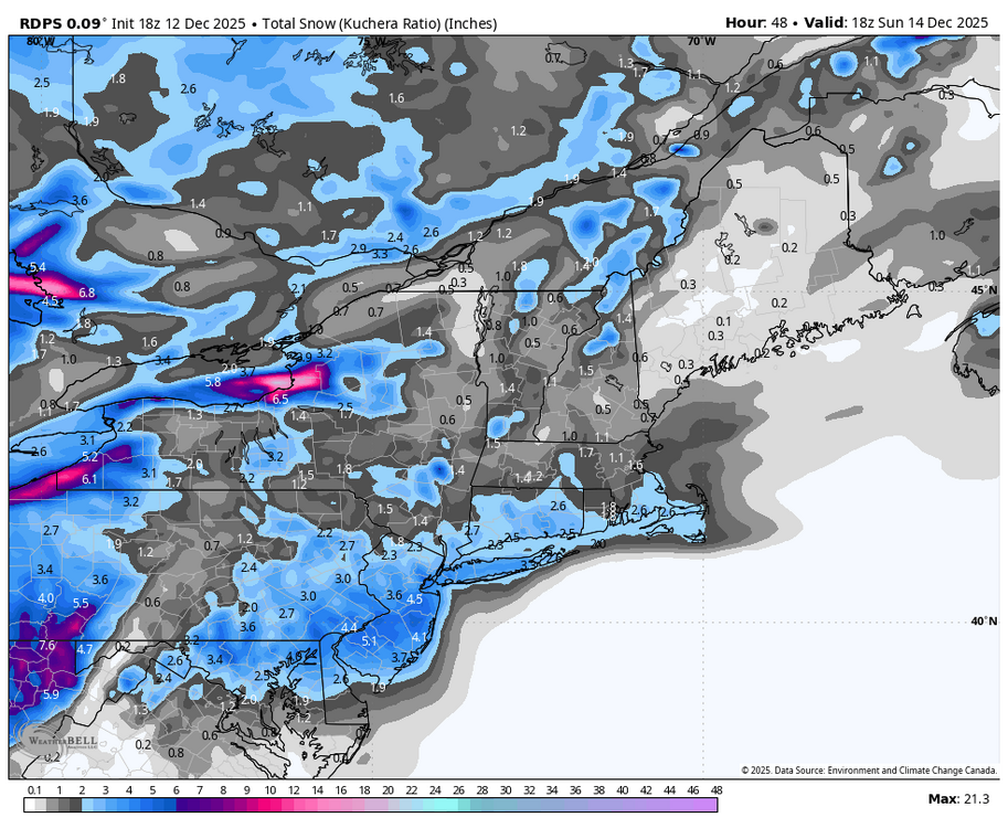
Here's my first call, going a little bit on the aggressive side with the band that sets up over I-95. I think that the regional models (NAM/RDPS/RRFS etc..) have a better handling on how this storm will do has there will be important mesoscale features determining total snowfall that the global models just aren't able to resolve. My thinking is that hypothetically if the banding can really get going along I-95 then NW and SE areas wouldn't do as well because of the subsidence that would result -
uh no - that was one of the greatest snowstorms in recent history for the Mid Atlantic. NYC's all time 24hr snowfall.
-
I barely talk to my next door neighbors…nevermind 3 houses up.
-

December 14th - Snow showers or Plowable snow?
Go Kart Mozart replied to Sey-Mour Snow's topic in New England
It's Belichick After Jordan threw him out of the house. -

Central PA Winter 25/26 Discussion and Obs
Blizzard of 93 replied to MAG5035's topic in Upstate New York/Pennsylvania
I still like my call of 1 to 3 for the LSV with a few lucky spots in York or Lancaster getting 4. The lower amounts of the range are likely to be north & west of Harrisburg. The higher end of the range is favored towards eastern York & Lanco. I think MDT has a decent chance of getting 2 inches. The RGEM & the Euro AI have been consistent the last couple of days & most closely resemble my current thoughts on this event.
-

12/14: Sunday funday? Will the south win again?
Maestrobjwa replied to TSSN+'s topic in Mid Atlantic
Well yeah I know it's technically "not important" but pardon me for merely being curious--I always wonder about the little things others don't think "matter"--just my nature. And in this case...clippers have been extinct for a decade so I was just wondering if this would count as the first since then -
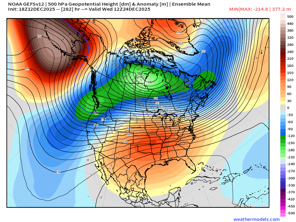
GEFS continuing the semi-interesting look going into Xmas Eve/Xmas. It’s obviously not your ideal coastal storm pattern but we’ve seen some interesting winter wx systems on looks like the below…overrunning snow/SWFE/potential ice…something to watch…you get a ripple or vort energy being shot across the center of the CONUS and it runs into that brick wall north of New England
-

December 2025 regional war/obs/disco thread
masonwoods replied to Torch Tiger's topic in New England
Mason NH -
Yes we had that in Hoboken too
-
18z ai with a Christmas miracle
-

2025-2026 ENSO
michsnowfreak replied to 40/70 Benchmark's topic in Weather Forecasting and Discussion
True, but its really no different than the other crowd during periods of cold. We will start to see random posts about warmth elsewhere on the planet. -
It's really not that important- but if you want to call it a clipper, that's fine.(not sure what a 'regular system' is exactly). It is a NS wave moving along an Arctic boundary, with some interesting mid/upper level dynamics at play. Not all 'clippers' behave the same way.
-

Pittsburgh/Western PA WINTER ‘25/‘26
Burghblizz replied to Burghblizz's topic in Upstate New York/Pennsylvania
We’ll see how this plays out but the warnings in the southern counties feels “aggressive”. 6-10” with “localized higher amounts”? Just doesnt feel like there is that kind of moisture to work with, despite the ratios -
Agree 100% on the Wednesday clipper being a classic example the difference the hills make. Although until that system DTW & White Lake were neck and neck.
-
Similar here. 3" of frozen crust. At least it's still white.
-
@Chris78 Just got to Deep Creek…when we drove past Wisp, guns were blazing all over the mountain.
-

Minor snowfall sunday 12/14/25 1-4” possible
SnoSki14 replied to WeatherGeek2025's topic in New York City Metro
I like 2-4" from this. Advisory is right on the money. Agree about the ratios. Some localized spots will definitely see 4"+ -

Minor snowfall sunday 12/14/25 1-4” possible
WestBabylonWeather replied to WeatherGeek2025's topic in New York City Metro
We were spoiled with all the bombs we got not too long ago. Back to reality. I’ll take the 4” -
I want this to happen with my soul, but damn, you don’t get much more hopium than an operational run at hour 316 on the 18z GFS. Lol
-
That’s a 5 day mean so there’s a really cold airmass in there once you subtract the 60° on Christmas out.