All Activity
- Past hour
-

Overnight Wednesday, November 5, 2025 Wind Event
weatherwiz replied to weatherwiz's topic in New England
Looks like the core of gusts last night was basically between 11 PM-2 AM just looking around at some obs which falls in line what guidance started to indicate but pretty crazy the decrease in LLJ intensity in the course of two days. -
 Leftover power outages at 8AM today after the late Wed eve-early Thu wind event. Pennsylvania45,455 New Jersey12,254 Maryland4,677 New York3,653
 -
How did I not read that as sarcasm?
-
 35 mph in Syosset & 37 mph in Muttontown for highest gust.
 -
Bummer on that length of time. So, you're going to do the right thing and eat and drink it all this morning to 'save' it, correct?
-
Much thanks for this OKX wind report. I'll close that these reports verified the advisory.
-
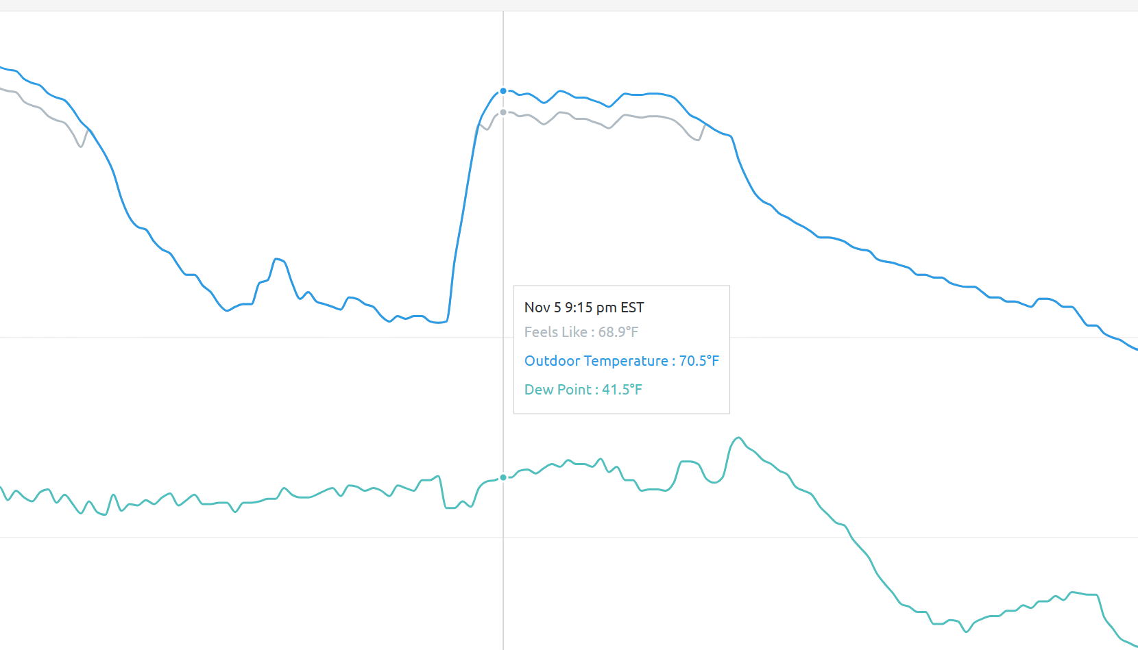
I literally did a double take looking at my backyard readings this morning! Cool spike with the front! Warming up nicely into the mid 50s already
-
I know, but the impetus behind it isn't needed
-
I just got an email update that says restoration is paused and estimate is 7PM. But those automated sites are trash. More importantly, considering that howling wind last night, it is an exceptionally nice morning.
-
Although the temp roared (literally with those winds) to a 72.3 high here yesterday, still not close to the record of 79.7 degrees from 2003.
-
I was gonna comment 'The breakfast of champions' lol. Hope the power returns soon!
-

Central PA Fall Discussions and Obs
pawatch replied to ChescoWx's topic in Upstate New York/Pennsylvania
Got up in the middle of the night to make sure my hot tube cover was still batten down. The one corner came unhooked but it was fine. Earlier this morning as the sun was coming up the sky was really neat. The full moon was still shining while the sun was coming up. Awesome sight !! -
I don't remember it linking up to the SE ridge last year like it did the previous 2 winters. I do remember the board commenting that we were happy to see it disconnected. The fact that it did not link up helped the Middle Atlantic score a good snowfall winter. Storm track was too far south for us.
-

2025-2026 ENSO
40/70 Benchmark replied to 40/70 Benchmark's topic in Weather Forecasting and Discussion
Absolutely. Makes perfect sense. My guess is that we can, but will have to "make hay", so to speak in reduced intervals of time relative to similar patterns in the past. -
DC Fox 5 winter outlook; reasonable forecast and good read. https://www.fox5dc.com/news/dmv-winter-2025-2026-outlook-above-average-snowfall-possible
-
It appears that the WPAC warm pool in conjunction with the cold over Siberia promotes the very fast Pacific Jet along the gradient between the two extremes of warm and cold. While we have observed the warm pool peak diminishing a bit in magnitude from the summers into winters, enough warmth is retained both on the deep subsurface and the surface to maintain the steep temperature gradient. I would like to see if we can at least get a few weeks when a -WPO links with a +TNH to know if there is at least some potential to weaken the Pacific Jet enough to allow a few benchmark storm tracks. But we won’t know if it’s possible until we can actually verify a potential weakening of the jet.
-

November 2025 general discussions and probable topic derailings ...
CoastalWx replied to Typhoon Tip's topic in New England
I don't see a big warm up. Maybe we get warmer near the 20th? The warm ups 10+ days out have been muted as we get closer. -
 A few spots and one ASOS like HPN was able to get the 60 mph gusts. Public Information Statement National Weather Service New York NY 727 AM EST Thu Nov 6 2025 ...HIGHEST WIND REPORTS... Location Speed Time/Date Provider ...Connecticut... ...Fairfield County... Bridgeport Airport 52 MPH 0209 AM 11/06 ASOS Norwalk 45 MPH 1136 PM 11/05 CWOP Bridgeport 40 MPH 0948 PM 11/05 NOS-NWLON Stamford 40 MPH 1240 AM 11/06 CWOP Danbury Airport 40 MPH 0109 AM 11/06 ASOS Fairfield 39 MPH 1245 AM 11/06 CWOP ...Middlesex County... Middletown 40 MPH 0319 AM 11/06 MESOWEST ...New Haven County... Bethany 49 MPH 1244 AM 11/06 CWOP Stony Creek 46 MPH 0110 AM 11/06 CWOP Lighthouse Point 45 MPH 1241 AM 11/06 WXFLOW Meriden Airport 41 MPH 0242 AM 11/06 ASOS Hammonasset 41 MPH 0358 AM 11/06 WXFLOW Waterbury Airport 39 MPH 0213 AM 11/06 AWOS ...New London County... Groton Airport 54 MPH 0217 AM 11/06 ASOS Groton 39 MPH 0156 AM 11/06 CWOP ...New Jersey... ...Bergen County... Teterboro Airport 55 MPH 1024 PM 11/05 ASOS Hackensack 40 MPH 1245 AM 11/06 DAVIS ...Essex County... Caldwell 49 MPH 1026 PM 11/05 ASOS ...Hudson County... Bayonne 57 MPH 1047 PM 11/05 WXFLOW ...Union County... Newark Airport 53 MPH 0202 AM 11/06 ASOS Linden Airport 43 MPH 1055 PM 11/05 AWOS ...New York... ...Bronx County... Fordham 51 MPH 1035 PM 11/05 NYSM ...Kings County... Brooklyn College 45 MPH 0155 AM 11/06 NYSM South Slope 41 MPH 0233 AM 11/06 CWOP ...Nassau County... Bayville 61 MPH 1246 AM 11/06 WXFLOW Wantagh 47 MPH 0200 AM 11/06 NYSM Merrick 45 MPH 0155 AM 11/06 CWOP 0.8 NW Uniondale 41 MPH 1100 PM 11/05 MESOWEST Massapequa Park 39 MPH 0130 AM 11/06 CWOP 0.9 SW Manhasset 39 MPH 0130 AM 11/06 MESOWEST ...New York (Manhattan) County... Midtown Manhattan 47 MPH 1045 PM 11/05 NYSM Central Park 44 MPH 1043 PM 11/05 ASOS ...Orange County... Montgomery Airport 46 MPH 1116 PM 11/05 AWOS Warwick 40 MPH 1245 AM 11/06 NYSM ...Putnam County... Brewster 42 MPH 1130 PM 11/05 NYSM ...Queens County... NYC/La Guardia 54 MPH 0215 AM 11/06 ASOS Kew Garden Hills 52 MPH 1050 PM 11/05 NYSM Breezy Point 48 MPH 1222 AM 11/06 WXFLOW NYC/JFK Airport 48 MPH 0239 AM 11/06 ASOS ...Richmond County... 2 SE Elizabeth 52 MPH 0154 AM 11/06 NDBC College of Staten Island 44 MPH 0120 AM 11/06 NYSM ...Rockland County... Suffern 42 MPH 1010 PM 11/05 NYSM ...Suffolk County... Stony Brook 70 MPH 0112 AM 11/06 CWOP Eatons Neck 61 MPH 0103 AM 11/06 WXFLOW Baiting Hollow 56 MPH 0220 AM 11/06 CWOP Great Gull Island 56 MPH 0403 AM 11/06 WXFLOW Southold 54 MPH 0215 AM 11/06 CWOP Farmingdale Airport 51 MPH 0103 AM 11/06 ASOS Fishers Island Airport 50 MPH 1049 PM 11/05 WXFLOW Shirley Airport 49 MPH 0112 AM 11/06 ASOS Westhampton Airport 49 MPH 0117 AM 11/06 ASOS Islip Airport 49 MPH 0125 AM 11/06 ASOS Shoreham 49 MPH 0135 AM 11/06 DAVIS Montauk Airport 47 MPH 0352 AM 11/06 ASOS Orient 46 MPH 1125 PM 11/05 CWOP West Gilgo Beach 46 MPH 0125 AM 11/06 CWOP Stony Brook 45 MPH 1256 AM 11/06 CWOP Fire Island CG 45 MPH 0120 AM 11/06 WXFLOW Great South Bay 45 MPH 0127 AM 11/06 WXFLOW Brookhaven 43 MPH 1245 AM 11/06 CWOP 1 E East Hampton Airport 43 MPH 0115 AM 11/06 AWOS Southold 42 MPH 0115 AM 11/06 NYSM Blue Point 42 MPH 0124 AM 11/06 WXFLOW Napeague 42 MPH 0140 AM 11/06 WXFLOW Mecox Bay 41 MPH 0953 PM 11/05 WXFLOW Stony Brook 41 MPH 1255 AM 11/06 NYSM ...Westchester County... White Plains Airport 60 MPH 1217 AM 11/06 ASOS Tappan Zee Light 14 54 MPH 1204 AM 11/06 WXFLOW Croton 43 MPH 0923 PM 11/05 WXFLOW New Rochelle 40 MPH 1045 PM 11/05 CWOP ...Maritime Stations... ...Connecticut... Stonington Outer Breakwater 54 MPH 0202 AM 11/06 WXFLOW 1 ESE Norwalk 51 MPH 1152 PM 11/05 WXFLOW USCG Academy 48 MPH 0149 AM 11/06 WXFLOW ...New Jersey... Jersey City 54 MPH 1127 PM 11/05 CWOP ...New York... Robbins Reef, NJ 55 MPH 1106 PM 11/05 NOS-PORTS Kings Point 55 MPH 1254 AM 11/06 NOS-NWLON 15 S Atlantic Beach 54 MPH 1120 PM 11/05 NDBC Northport 54 MPH 0105 AM 11/06 DAVIS 26 SSE Robert Moses State Pa 51 MPH 0100 AM 11/06 NDBC Shinnecock 51 MPH 0110 AM 11/06 WXFLOW Point O Woods YC 49 MPH 0122 AM 11/06 WXFLOW Fire Island CG 49 MPH 0151 AM 11/06 WXFLOW Larchmont Harbor 48 MPH 1057 PM 11/05 WXFLOW &&
- 56 replies
-
- 1
-

-
- wind damage
- power outages
- (and 1 more)
-

Central PA Fall Discussions and Obs
mahantango#1 replied to ChescoWx's topic in Upstate New York/Pennsylvania
I know it's early in the season, and we will have more stronger winds for months on end. But i'm sick of this wind already! -
2025-2026 ENSO
40/70 Benchmark replied to 40/70 Benchmark's topic in Weather Forecasting and Discussion
Your contention is that the warm pool creates a +WPO pattern that promotes both a western storm track, and a fast jet that knocks down PNA ridges/shears phasing attempts and causes suppression, correct? -
The 6z Euro may have been a bit more vigorous that the 0z.
-
 long day ahead, lot of small outages
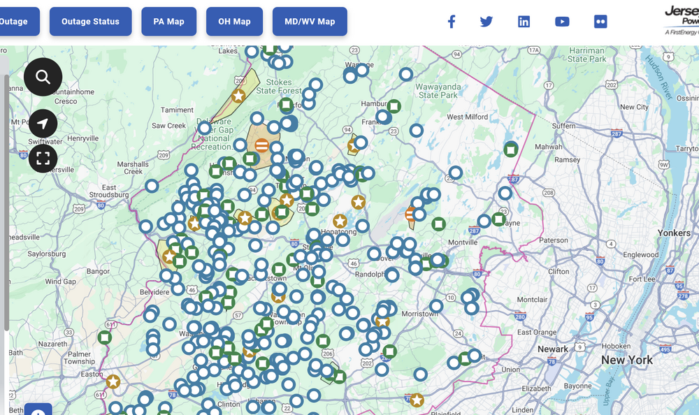
-

November 2025 general discussions and probable topic derailings ...
dendrite replied to Typhoon Tip's topic in New England
There’s multiple cold shots before Thanksgiving. But yeah…maybe warming up more near the 20th, but that’s 2 weeks away. -
 After the cold shot . The week leading up to Tgiving looks AN. Fast PAC flow and no cold left
 -

Central PA Fall Discussions and Obs
Mount Joy Snowman replied to ChescoWx's topic in Upstate New York/Pennsylvania
Yes MU mentioned how they and LNS experienced this. Talked about how compressional warming can often be maximized right ahead of a cold front.