All Activity
- Past hour
-
Pressure looks to be ~976-77mb per dropsonde.
-
Yesterday was decent until 3 here, and I think the aftn improves after 1-2p. Could be worse.
-
Yeah, that warm blob seems to want to be a mainstay.
-

2025 summer max contest -- enter by 06z June 20
biodhokie replied to Roger Smith's topic in Mid Atlantic
DCA: 100 IAD: 101 BWI: 101 RIC: 100 -
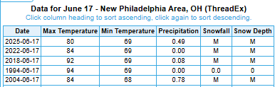
Definitely some warm lows in recent nights across the Buckeye state. Several locations were not far from record warm daily minima yesterday, with New Philadelphia area tying the record warm low of 69F, set previously in 2022, 2018 and 1994.
-
Y’all had 6 straight days of doom and clouds. Not just 2 midweek sandwiched between beauty
-
Offset to this will be higher dews. So while EXTREME temperatures are pretty much off the table some nasty HI readings and sultry overnights are upcoming. Max HI 105-110, maybe a little above that (112?),
-
Either we have siting standards or we don't. A weather station is supposed to be in an open area, not underneath trees and overgrowth.
-
Blizz tried to tell you.
-
Models are often overdone with the torch in the longer range. And with wet ground it makes Even less sense
-
So is a bog. You are not going to put a thermomemter in the mud, are you?
-
NHC explicitly states major hurricane at landfall and that it is undergoing RI in the latest advisory. A small eye is peeking out now and all systems look “go” for this rate of intensification into the coast. The impact area isn’t exactly unpopulated either with a lot of towns along the coast regardless where the eye crosses. Really think this becomes a significant hit for Mexico
-
Looking at the Michigan roundup from yesterday, a number of locations saw temperatures climb at or above 90F, including as hot as 92F at Auburn 2NE. Unfortunately, the urban chill island of Detroit could only muster a disappointing 86F. Going to be another one of those summers, where @michsnowfreak is bragging about the lack of 90F heat, whilst complaining about urban heat islands, all the while rural areas where nobody lives rack up plenty of 90s. In order for Detroit to record some readings in the 90s, it looks like some rural parts of the State will need to reach well into the mid 90s, even upper 90s. Maybe a tall ask.
-
We have family we visit near there. Happens in July and August on the regular. Never truly summer there
-
It has been miserable weather, but one positive is it revived my romaine lettuce. Yesterday I picked a ton of pretty high quality lettuce, very unusual for mid June. This cloudy, cool damp weather has been great for the cool season vegetables. It's really extending them. I'm still picking a lot of broccoli too. Of course not great for the warm weather vegetables. My tomatoes are off to a slow start. I'm glad this pattern is finally ending. It's nice to still be getting the lettuce, but the warm weather vegetables obviously are the more important thing now. It's time to burn away the cold weather vegetables and get the warm weather vegetables going.
-
Yes and it's always the worst plants not the ones we want
-
especially ants, they are right outside my front door lol, if I get a food delivery I have to be at the door otherwise the ants attack it en masse.
-
Be careful what you wish for lol. I have seen such an overgrowth of vines (I wrote about it in the NW thread) that it's hard to open my front door or get into my mailbox. All of this happened in just 5 days. I'm going to be spraying defoliant this weekend.
-
heat index already 100F imby
-
Hopeful for at least some brightening if not breaks in the clouds later this afternoon. What a run of weather for mid June. https://www.meteo.psu.edu/ewall/PSUGOES_NE/loop60v.html
-
82/76
-
Bugs are thriving.
-
Wow Gaithersburg Airport reporting 84/82? That DP might be off but it's steamy for sure Oh and I gotta do some yardwork wheeeee!
-
Plants that are acclimated to this crap weather are exploding, as it warms up now Watch Out.
-
A nice steady “under the radar “ rain falling here again today . Doesn’t look like any sun unless it’s late day .


