All Activity
- Past hour
-

November 2025 general discussions and probable topic derailings ...
dendrite replied to Typhoon Tip's topic in New England
CON is -2.2 mtd. MHT -2.7. -
Farmingdale too, low there was 31.
-
Bottomed out at 31F here.
-
Hmmm. Doesn’t say Howard, but has everywhere around us?
-
27.6 degrees for the low here. Nice inversion ongoing, high up (+3500 elevation) is in the low 40's with valleys in mid to upper 20's. Currently 29.8/25.0 at 8 am with just a bit of high cirrus in the sky.
-

November 2025 general discussions and probable topic derailings ...
CoastalWx replied to Typhoon Tip's topic in New England
Tomorrow AN for sure. Should be a nice day. -
November 2025 general discussions and probable topic derailings ...
CoastalWx replied to Typhoon Tip's topic in New England
2nd,3rd, and yesterday. Today will avg BN I think. Logan was 33 this morning. -
Current forecast for Chicago is LOL worthy.
-
(002).thumb.png.6e3d9d46bca5fe41aab7a74871dd8af8.png)
Central PA Fall Discussions and Obs
ChescoWx replied to ChescoWx's topic in Upstate New York/Pennsylvania
The NWS has terminated the growing season across the entire area as most spots have now seen freezing or frost conditions this season. The only exception remains the highest spots in our area including Atglen, West Grove and here in East Nantmeal where we only dropped down to 33.9 this morning. Our typical coldest spot just a few miles north of here at Warwick Township dropped to 24.2 degrees this morning - almost a 10-degree swing based on elevation. That was the 10th sub-freezing low this season at Warwick. Here in East Nantmeal we will have to wait for our first freeze till our cold shot that arrives on Monday night. The latest first freeze I have recorded here was last year on November 13th. Today we will see high temperatures well up into the 50's. Some showers are likely tonight before our warmest day for the next week tomorrow with highs into the low 60's. We start to cool down on Sunday with more rain possible into the evening before we turn much colder to start the new work week we could even see a snow flurry by Monday night.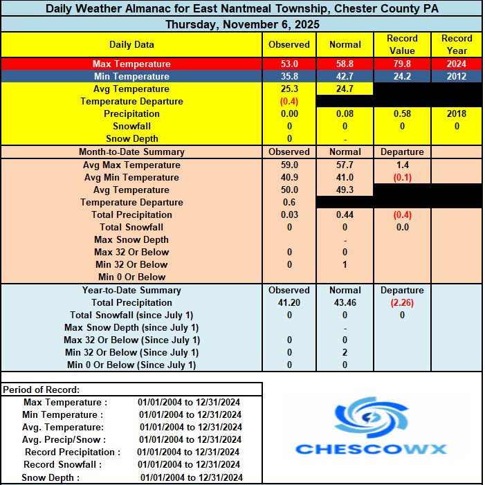
-

November 2025 general discussions and probable topic derailings ...
HimoorWx replied to Typhoon Tip's topic in New England
Finally below freezing for the first time. 29.8 for the low. -
E PA/NJ/DE Autumn 2025 Obs/Discussion
ChescoWx replied to PhiEaglesfan712's topic in Philadelphia Region
The NWS has terminated the growing season across the entire area as most spots have now seen freezing or frost conditions this season. The only exception remains the highest spots in our area including Atglen, West Grove and here in East Nantmeal where we only dropped down to 33.9 this morning. Our typical coldest spot just a few miles north of here at Warwick Township dropped to 24.2 degrees this morning - almost a 10-degree swing based on elevation. That was the 10th sub-freezing low this season at Warwick. Here in East Nantmeal we will have to wait for our first freeze till our cold shot that arrives on Monday night. The latest first freeze I have recorded here was last year on November 13th. Today we will see high temperatures well up into the 50's. Some showers are likely tonight before our warmest day for the next week tomorrow with highs into the low 60's. We start to cool down on Sunday with more rain possible into the evening before we turn much colder to start the new work week we could even see a snow flurry by Monday night.
-
Here in Raleigh we kind of have a double peak with different trees. We just had the peak of the first wave I think:
-
That’s a great point PF. I hadn’t thought too much about it because we certainly get snowpack and skiing like this in November, but probably not too often in this part of November. Especially at this time of the season, that average snow depth at the stake is quite the “average” vs “typical”. Periods like this are the counterpoint to all those early Novembers when the pattern is just benign, pleasant, stick season weather, which happens quite often. Those videos coming out of Jay Peak definitely show how good some of the riding has been – one of my students was showing me video yesterday as he wondered why in the world he wasn’t out there: https://www.instagram.com/reel/DQuj2viEr4X/
-
36 for the low, first sub 40 of the year
-
Triple digits in Deep Creek would remind me of winters of the past there (and last year). Fingers crossed a good year for the ski resorts.
-
First appearance in the metro zones 28 29 30 179 FPUS51 KLWX 071134 ZFPLWX Zone Forecast Product National Weather Service Baltimore MD/Washington DC 633 AM EST Fri Nov 7 2025 DCZ001-071500- District of Columbia- Including the city of Washington 633 AM EST Fri Nov 7 2025 ...FREEZE WARNING REMAINS IN EFFECT UNTIL 8 AM EST THIS MORNING... .TODAY...Sunny this morning, then becoming partly sunny. Highs in the lower 60s. South winds 10 to 15 mph with gusts up to 30 mph. .TONIGHT...Showers likely. Lows in the lower 50s. Southwest winds 5 to 10 mph with gusts up to 25 mph. Chance of rain 70 percent. .SATURDAY...Sunny. Highs in the upper 60s. Northwest winds around 5 mph. .SATURDAY NIGHT...Partly cloudy in the evening, then becoming mostly cloudy. Lows around 50. Southeast winds around 5 mph. .SUNDAY...Mostly cloudy in the morning, then becoming partly sunny. A 50 percent chance of rain. Highs in the upper 60s. Southeast winds around 5 mph, becoming southwest in the afternoon. .SUNDAY NIGHT...Mostly cloudy with a 50 percent chance of rain. Lows in the lower 40s. .MONDAY...Mostly sunny. Highs in the upper 40s. .MONDAY NIGHT...Partly cloudy with a chance of snow and rain. Lows in the lower 30s. Chance of precipitation 30 percent. .VETERANS DAY...Sunny. Highs in the mid 40s.
-

November 2025 general discussions and probable topic derailings ...
jbenedet replied to Typhoon Tip's topic in New England
For Logan only days BN were 2nd and yesterday. Overall very close to average for the week so far. Today and tomorrow will take it to firmly above average week. -
Itching to get back up there, such a beautiful area.
-
No more freeze/frost products for anyone except S MD 911 NOUS41 KLWX 071257 PNSLWX DCZ001-MDZ008-011-013-014-018-504-506-508-VAZ053>055-527-080100- Public Information Statement National Weather Service Baltimore MD/Washington DC 757 AM EST Fri Nov 7 2025 ...GROWING SEASON HAS ENDED FOR THE PORTIONS OF NORTHEAST MARYLAND, CENTRAL MARYLAND, & NORTHERN VIRGINIA .. Based on freezing temperatures last night into this morning, the growing season has been declared over for the following counties: In Maryland: Cecil, southern Baltimore, Prince Georges, Anne Arundel, Charles, central and southeast Montgomery, & southeast Harford. In Virginia: Fairfax, Arlington/Falls Church/Alexandria, Stafford, central and southeast Prince William, & Manassas/Manassas Park. In Washington DC: Washington DC As a result, no Frost/Freeze headlines will be issued for these areas until Spring 2026.
-

Central PA Fall Discussions and Obs
Superstorm replied to ChescoWx's topic in Upstate New York/Pennsylvania
29F for low. Beautiful sunrise! . -

2025-2026 ENSO
40/70 Benchmark replied to 40/70 Benchmark's topic in Weather Forecasting and Discussion
Found it. If Anthony didn't post the EURO, then the EURO looks just like whatever he posted. -
Bridgeport, Islip, and White Plains all experienced their first freeze of the season. Today's Low Temperature and First Freeze Data: Bridgeport: 32°; Last Year: November 13; Normal: November 4 Islip: 32°; Last Year: November 10; Normal: October 28 White Plains: 32°; Last Year: November 13; Normal October 28
-
LONG TERM /MONDAY THROUGH THURSDAY/... Sunday`s cold front is expected to be offshore by Monday morning. In its wake, the deep parent upper trough and its accompanying cold airmass will pivot overhead. Mid/upper-level heights and low/mid- level temperatures are forecast to be 3-4 standard deviations below normal per NAEFS climatology (i.e. 850 hPa temps -8 to -13 C 12Z Tuesday, which may challenge the daily record for the KIAD UA). Strong cold air advection and a persistent pressure gradient between low pressure over southeastern Canada and Polar high pressure building in from the Midwest will lead to blustery conditions. Despite downsloping northwest flow and peaks of sunshine, high temperatures on Monday and Tuesday will struggle to escape the 40s. In fact, some guidance keeps high temperatures in the 30s for most of the region (coldest Tuesday). Higher elevations will be notably colder by about 10-15 degrees, and wind chills will be a factor as well (running 10-20 degrees below the air temps). Wind chills may not get much above freezing for very long Monday and Tuesday, even during the afternoon hours as winds gust to 30 mph or more. With the northwest flow comes a favorable trajectory off of the Great Lakes. This is expected to result in the first accumulating upslope snow event of the season (likely begins late Sunday night and persists into Monday night or perhaps early Tuesday morning). It remains a bit too soon to speculate on exact amounts, but the first plowable snowfall of the season is becoming ever more likely along and west of the Allegheny Front. Some guidance implies possible warning-level snowfall along the west-facing slopes of the higher peaks, which makes sense given some instability and moisture overlapping the DGZ (as evidenced by a high Snow Squall Parameter). An embedded shortwave and higher FROUDE numbers indicate the potential for precipitation moving east of the Allegheny Front, with accumulating snow possible particularly late Monday into Monday night into the foothills east of the highest ridges. Depending on the strength of the wave and the amount of available moisture, snow showers may dot the landscape well into the Piedmont and possibly even the metro areas Monday night. Although significant snowfall accumulation is unlikely east of the Appalachians, the cold air and snow shower potential would be a fitting reminder of the record Veteran`s Day snowstorm that occurred nearly 4 decades ago.
-
2025-2026 ENSO
40/70 Benchmark replied to 40/70 Benchmark's topic in Weather Forecasting and Discussion
I think the absence of a severe RNA would also help...sure, the Pac jet would still mitigate KU potential, but it's not absolutely prohibitive to more moderate events. -
November 2025 general discussions and probable topic derailings ...
CoastalWx replied to Typhoon Tip's topic in New England
Semi intriguing op runs last night.


