All Activity
- Past hour
-
Cold at 20.3 this morning. Might be a while before that's seen again. Please don't be gone too long.
-
Tenacity is great stuff.....I don't use the weed stuff anymore, either....tenacity takes care of it.
-
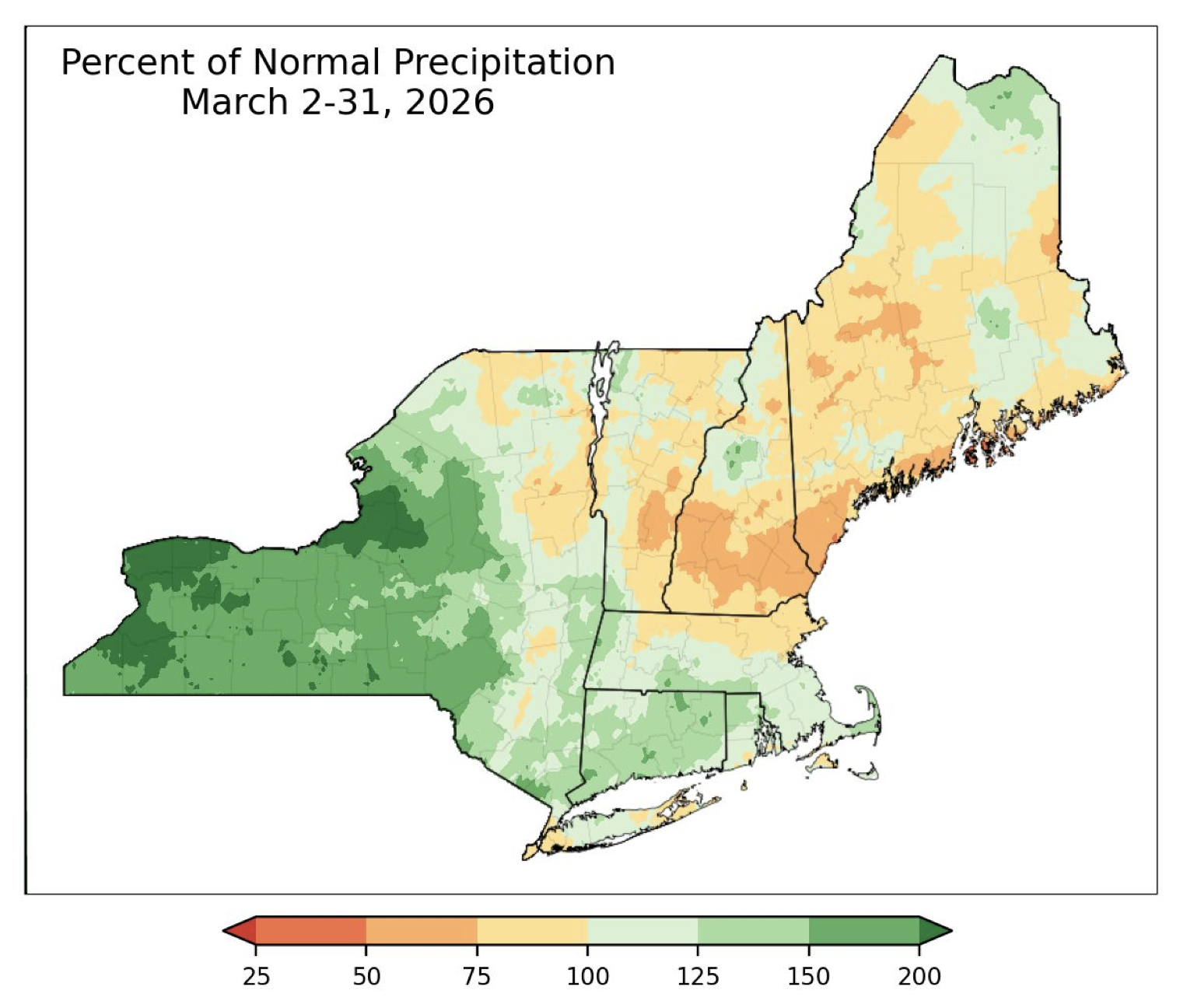
March was really dry despite a couple of minor snow events

-
Aren’t you buried in snow ?
-

2026-2027 El Nino
snowman19 replied to Stormchaserchuck1's topic in Weather Forecasting and Discussion
@Bluewave -
Bottomed out at 21, the average low for this date is 34.
-
22.8 at 7 am.................. Up to 27.2 at 8am. Probably more than 80% of the fruit is frozen.
-

2026-2027 El Nino
40/70 Benchmark replied to Stormchaserchuck1's topic in Weather Forecasting and Discussion
Yes, this is why I am going to be keeping a close vigil on the RONI/ONI separation. I don't view the delta is a positive for winter enthusaists. -
LOL, just glanced at Canaan NWR site, they got down to 6 degrees.
-
Currently 27.9/17.5 at 7:45 after a 27.2 low. No warnings/advisories out this way, I think the 'growing season' doesn't start until the 25th?? Seen PLENTY of folks sticking stuff into the ground last week, WAY too early for our location and they probably got bit.
-
36 now after low of 34.1. Proximity of the river evident.
-
Not really…nothing is growing. This surface moisture will be gone quickly unless we keep it up.
-

-
You soaked there now
-

2026-2027 El Nino
bluewave replied to Stormchaserchuck1's topic in Weather Forecasting and Discussion
We have plenty of time to watch this one develop. Remember, these ENSO plume forecasts are just basically repeater models. They extrapolate the current conditions going forward. They are correct when the actual conditions repeat. When changes occur they exhibit errors. So if these record WWBs continue, then we have a shot at what they are showing. All I can say is that the models did a great job on the plumes from April of 2023. We would probably need a wind reversal on the order of June 2014 to avoid a +2.0 or greater ONI outcome. Once we verify the June conditions then things will come into better focus. The big story in 2023-2024 was the models underestimating the Nino ridge and warmth along the Northern Tier and overestimating the Aleutian low and troughing in the South and East. So it will be interesting to see how things go with this event. -
Not a heck of alot of lift around but maybe a chance for a few strong storms Tuesday north and west...been a pretty decent signal for a few days. maybe some sort of weak pre-frontal trough around?
-
30.4. Lots of 20s on the MD mesonet.
-
36 for the low, no freeze!
-
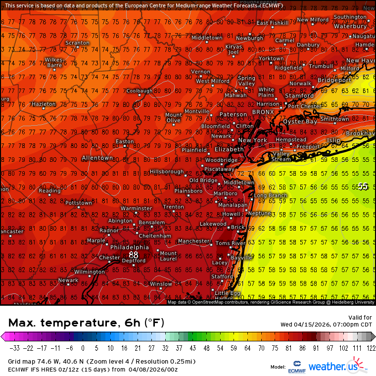
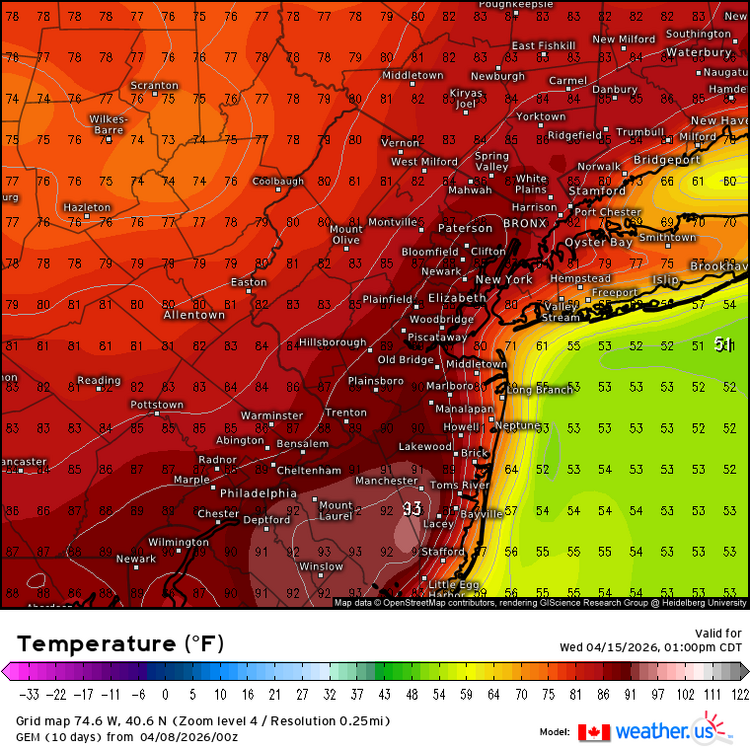
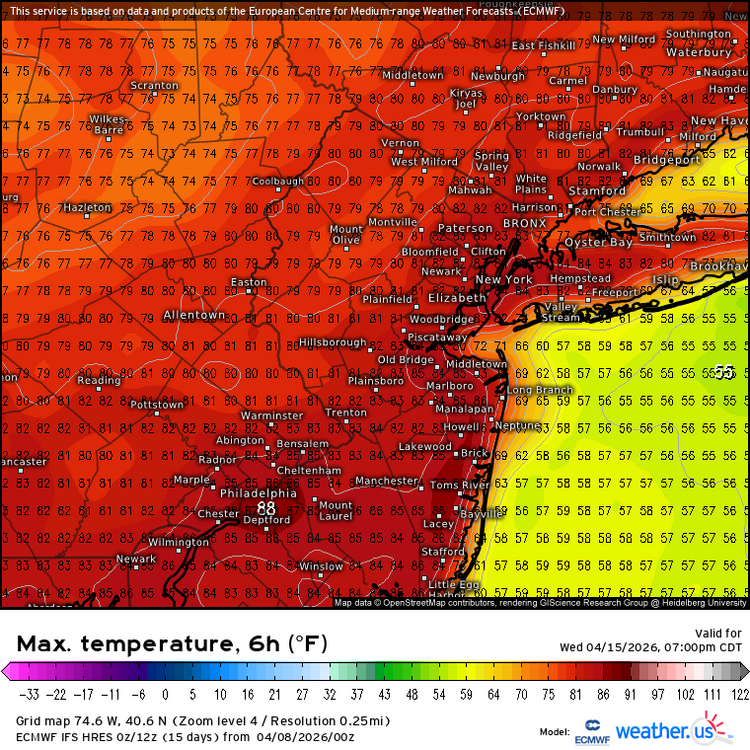
The cooler Euro Mid 80s in the warmer spots in Central NJ is probably the floor and the Canadian low 90s is the high end potential. Will probably come down to frontal timing and clouds. But the signal is there for the warmest readings of the year so far.
-
Yep come March it’s WACO lately
-
14° from my low. Yay April?
-
The organic matter is the key. The chemical ferts are like crack, they juice the grass but the effects wear off quickly and they don't contribute to the long-term microbial biodiversity in the soil, which is important for plant health. Lawn looks awesome ! Mine's still dormant.
- 1 reply
-
- 1
-

-
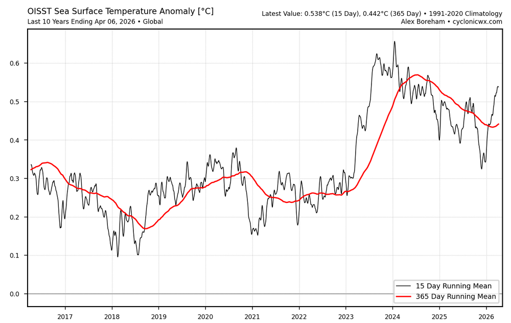
Another perspective on global oisst. So far this year looks a lot like 2023, which had a large rise in SST at the very beginning of the nino cycle. This year started its rapid rise even earlier around New Years. https://cyclonicwx.com/sst/
-
Seems like we need to wait til Tuesday down here..otherwise its 40s and 50s
-
WACO ?
.thumb.JPG.418e8a9a2902ae687ec35ff4bc0e038e.JPG)