All Activity
- Past hour
-

E PA/NJ/DE Winter 2025-26 Obs/Discussion
Birds~69 replied to LVblizzard's topic in Philadelphia Region
I tell ya I don't think I lost more than 1-2" (if?) from the storm 2 weeks ago. Depth-wise everything looks practically the same. Lawns, piles on side of roads and parking lot mountains. And it's not the dirty black crap either...it's generally still white. 27F -

Friday February 6 FROPA / WINDEX small event
JACKASS replied to HoarfrostHubb's topic in New England
You feel the dong? -
March seems to be decadal. 2010s had some great March months but the last one was 2019 where 10.4 fell in central park.
-

Friday February 6 FROPA / WINDEX small event
Damage In Tolland replied to HoarfrostHubb's topic in New England
Something tells us this is going to be more widespread than a local dong. It’s got that feel. -
 @Jersey Andrew but… I should add that 83 storm was a classic Nino STJ moisture bomb storm like Feb 2010 and Jan 2016. If we do get a MECS HECS storm it’s unlikely to have that level of STJ moisture feed. Even 96 didn’t. It had to snow for 36 hours to get those crazy totals in 1996. Our absolute top end is probably capped a little by the Nina. But we can definitely get VERY big snowstorms in a Nina.
 -

Friday February 6 FROPA / WINDEX small event
HoarfrostHubb replied to HoarfrostHubb's topic in New England
Wunderground app is bonkers here. 1-3” Friday night. 3-5” Saturday. -
Friday February 6 FROPA / WINDEX small event
HoarfrostHubb replied to HoarfrostHubb's topic in New England
If Cumberland, RI gets nothing, there will be a FURIOUS musician. RAGING in ALL CAPS -
Anytime we have blocking in February it’s possible. It’s true most HECS storms are in ninos but not all. Jan 96, Jan 2000 and Feb 2006 were all a Nina. And March 2018 was borderline HECS up here and that was a Nina.
-
Just seen where there’s 22,000 in Mississippi and 3000 in Tennessee that are still without power from the ice storm two weeks ago. .
-
 I think this better belongs in an “after hours” forum
 -
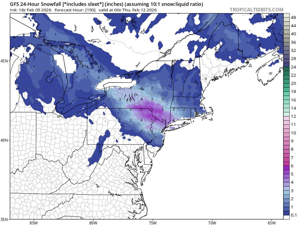
Says 24h @ 150?
-
The third week of March is typically the turning point. Yes, it CAN snow until April, like 2018 for example, but that's highly anomalous. So by that measure we have about 5 weeks left of wintry potentials. Anything after should be considered a treat.
-

Friday February 6 FROPA / WINDEX small event
ORH_wxman replied to HoarfrostHubb's topic in New England
If he gets 3-4” and ORH, me and Scooter get 1-2”, best event of the season. -
I saw over 2 foot think frozen dirt other day that was excavated for a construction project... haven't seen frost that thick in years
-
Friday February 6 FROPA / WINDEX small event
Damage In Tolland replied to HoarfrostHubb's topic in New England
All the new snow literally is just going to blow . Snow blowing and shoveling immediately will be paramount to increasing the banks -

Friday February 6 FROPA / WINDEX small event
dendrite replied to HoarfrostHubb's topic in New England
It’s all going to end up in the Atlantic or around the OWD ASOS. -
Obligatory 240 snowmap GFS off hour:
-
ask anyone irish....it's always cold on st patty's day....i was down in monmouth co i think it was 2003 in march, we were at a meeting at a school in matawan and it started snowing. it started coming down heavy and our district called early; but we were already stuck at this meeting. it got very bad quickly going up the gsp; heavy wet flakes.
-

Friday February 6 FROPA / WINDEX small event
ineedsnow replied to HoarfrostHubb's topic in New England
Forgot we have some good winds after this!! Going to look pretty awesome if we can get 3 plus -
Thank you
-
Pretty solid draft, too. That trade would have sucked if they included this year’s pick.
-
now that is funny....they do have mountain snows, and they do get these awesome hail storms that actually can accumulate and look like snow otg.....see them in bogota.
-
In the very mild air mass, dense fog developed late overnight and has persisted all day in many parts of eastern WA and southern interior BC. It returned to yesterday's very warm readings closer to the coast and also in chinook zones. Some current readings: 73F Tillamook OR, 68F Cut Bank MT (71F highest value in MT), 59F Portland OR and Abbotsford BC (Fraser valley), 36F dense fog Spokane WA, 43F dense fog outside my place, visibility under 100 yards. Probably sunny on local peaks but visible satellite shows widespread low cloud in valleys.
-

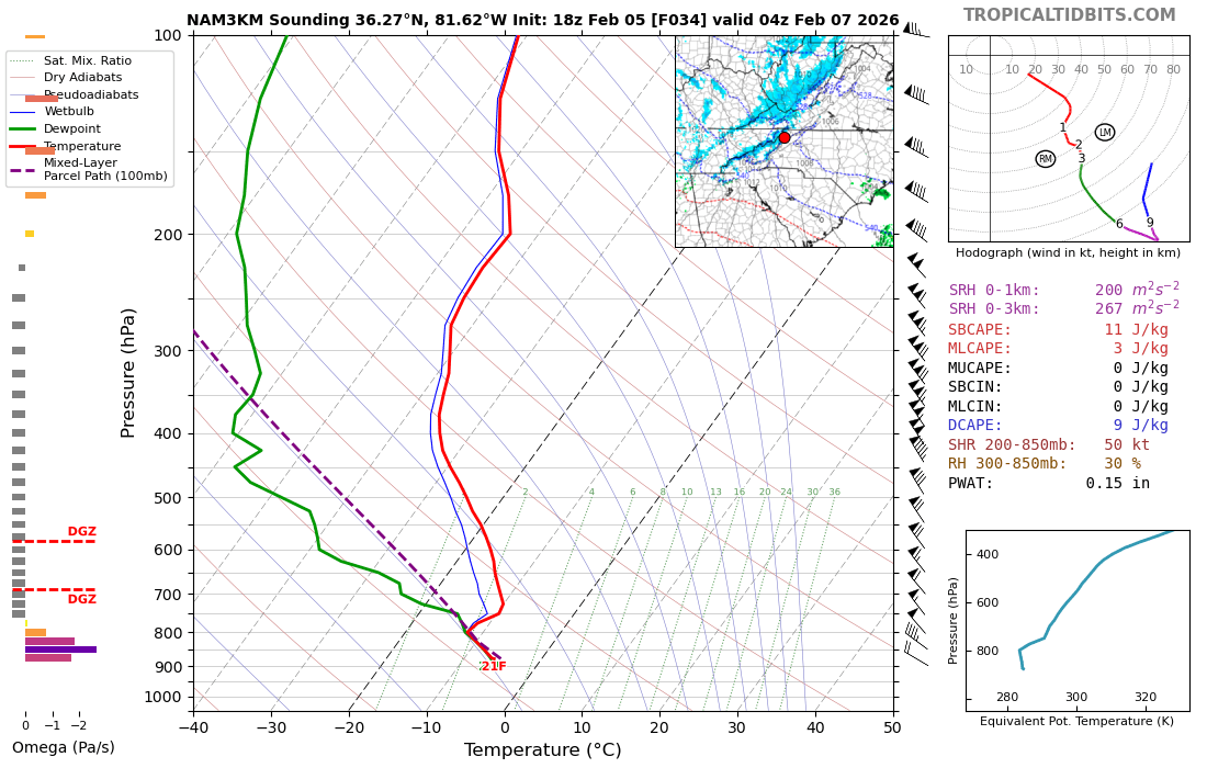
2025-2026 Fall/Winter Mountain Thread
Tyler Penland replied to Buckethead's topic in Southeastern States
Yeah, especially the CCTI side of town. The bypass area always scores during these type systems. Can see some wide variance from the bypass towards Deep Gap but the NAM has pretty deep moisture for a while tomorrow afternoon/night.
-
Friday February 6 FROPA / WINDEX small event
Damage In Tolland replied to HoarfrostHubb's topic in New England
Folks better measure this the second it stops . Otherwise it’ll be blown into 5 foot drifts against snowbanks