All Activity
- Past hour
-

“Cory’s in NYC! Let’s HECS!” Feb. 22-24 Disco
ineedsnow replied to TheSnowman's topic in New England
Destroyed -
News 12 basically saying 10-20 with locally over 24
-
This baby is right in my G Spot... Thing of beauty!

-
NAM is thinking BECS .
-
-

“Cory’s in NYC! Let’s HECS!” Feb. 22-24 Disco
Damage In Tolland replied to TheSnowman's topic in New England
Cane gusts back to Albany ! -
You can never ignore that corridor of shit air screwing it up for many
-
Good morning everyone. Has forky posted a comment yet? Stay well and safe, as always …
-

“Cory’s in NYC! Let’s HECS!” Feb. 22-24 Disco
weatherwiz replied to TheSnowman's topic in New England
Big time wind damage across SE MA and the Cape, coastal RI, and far SE coastal CT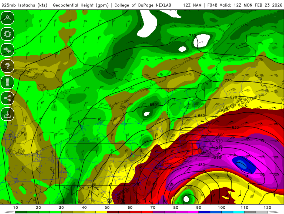
-
Biblical nam run.
-

“Cory’s in NYC! Let’s HECS!” Feb. 22-24 Disco
Typhoon Tip replied to TheSnowman's topic in New England
Marginal ... At 24 hours, prior to the amplitude setting up over the MA, the heights over the Florida Panhandle are 582 N, to 584-ish S, which is on the fence ... arguable a very minor stressing of that hypothetical rule. However, the other part of that, which is actually the more important aspect, the wind flags are < 40 kts on average. That means that the flow is not preconditioned to a compressed state. Such that as the S/W/phase going on over top in latitude, doesn't have the southern momentum being absorbed in the baseline velocity anomaly. Words get a bit pricey in that... but it has to do with whether a wind max is actually differentiable in the U component of the flow. For example, if the ambient velocity of the flow (U component) is humming along at 70 kts, and a powerful S/W with a 110 kts wind max up in Manitoba has it's sights set on the TV ... as it descends the stream lines, it's 110 -70 = 40 kts of differential. Not terrible. But, if the ambient flow is only 30 kts, that becomes a much bigger velocity left over to force jet responses. The sign that the former "robbing"/absorption is taking place, the vorticity begin to slope backward and the trough's axis into the southern flanks look bends back positive. Long than I wanted... In this case, the marginal limitation is easily overcome. Arithmetically, this whole amplitude has vast momentum compared to a 584 dm hgts, with limited or 0 geostrophic wind anomaly. -
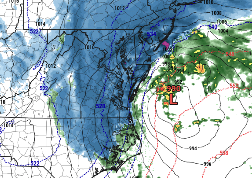
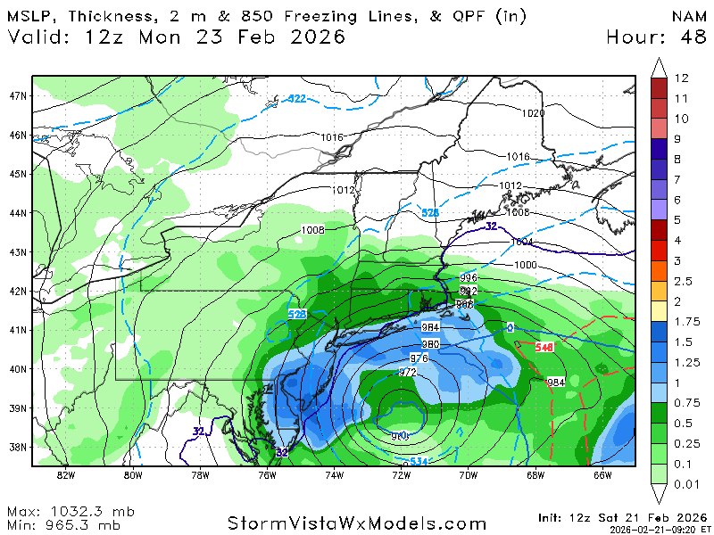
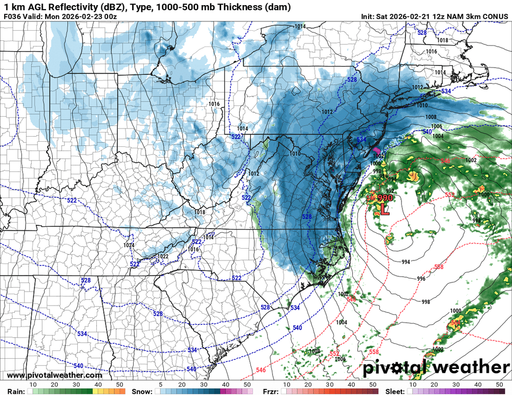
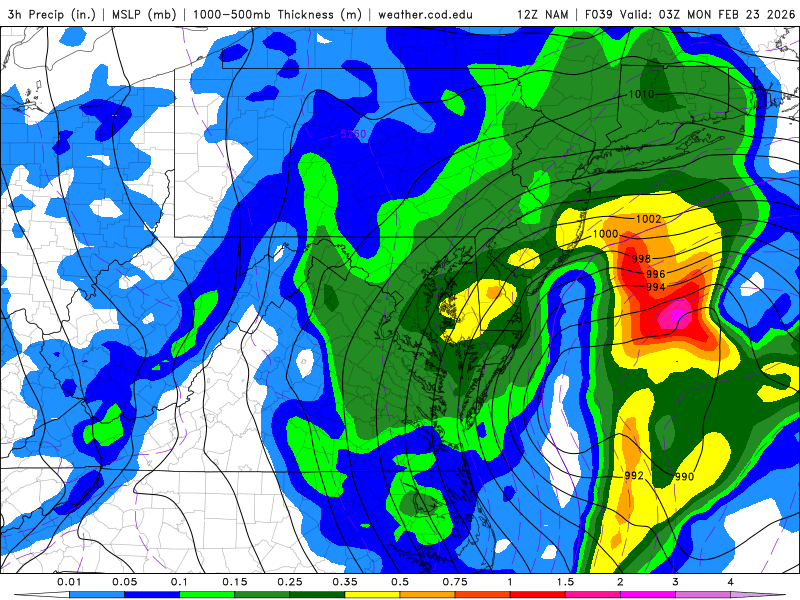
Already 968 a bit east of DE
-

Richmond Metro/Hampton Roads Area Discussion
mikeeng92 replied to RIC Airport's topic in Mid Atlantic
Im going with the positive bust. This isnt a typical Miller B waiting for the storm to bomb. Ton of energy dropping in with the ridge out west and the low has already formed in Georgia before moving up the coast. The NAM nailed the January storm , if it can verify like the pics below itll be like day 2 of 2016 without the cold air. Snow will accumulate when your in the heavier bands. Either way it will look epic falling.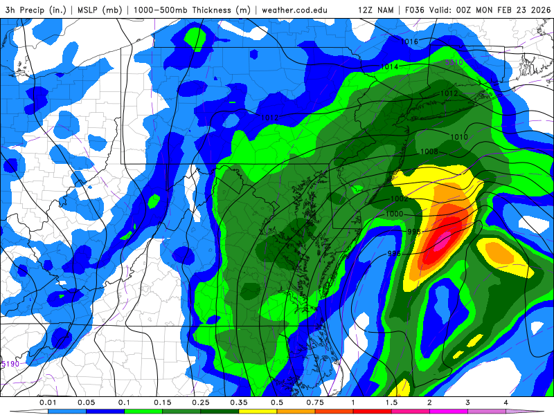
-
Usually these things take longer to get cranking than modeled. I feel good about our timing.
-

2/22-23 "There's no way..." Storm Part 2
Solution Man replied to Maestrobjwa's topic in Mid Atlantic
Scoring in the evening is how we do it -
Frame it.
-
nam down to 968 at 2/23 9z / 4am sunday
-
Go on
-
Woah, woke up to a Blizzard Warning!!! I don't remember the last one. I'm.going food shopping soon, it's going to be an absolute nightmare.
-

“Cory’s in NYC! Let’s HECS!” Feb. 22-24 Disco
Baroclinic Zone replied to TheSnowman's topic in New England
7mb stronger than 06z run. -
Not defending it, because it was irresponsible at the time. But you do recall how everyone on here jumped at the NY Post for it's sensational headline a few days ago warning of "up to a foot" ... It's a really fine line between hype and communicating risk
-

February 22-23 Storm Thread/OBS
Violentweatherfan replied to Mikeymac5306's topic in Philadelphia Region
This is as close to an analog as you can get. Finally I see an event with the MJO in phase 3 and a weak or transitioning La Niña thanks -
“Cory’s in NYC! Let’s HECS!” Feb. 22-24 Disco
ineedsnow replied to TheSnowman's topic in New England
Holy shit just saw the HRRR and now the NAM WOW!!!! -
3k has the inverted trough over Winchester with the ccb over 95.