All Activity
- Past hour
-

November 2025 general discussions and probable topic derailings ...
SJonesWX replied to Typhoon Tip's topic in New England
when does the warmup start? asking for a friend -
first call: BWI: 25.6" DCA: 17.8" IAD: 27.2" RIC: 8.9" ----- SBY: 11.1"
-
Lock it in!
-
BWI: 23.2 DCA: 16.6 IAD: 25.6 RIC: 10.1 Tie Breaker SBY: 11.8 White Christmas
-

November 2025 general discussions and probable topic derailings ...
Ginx snewx replied to Typhoon Tip's topic in New England
Hilltop ftw -
I wasn’t insinuating that 2nd year Nina’s are bad. It’s 3rd year triple dip Nina’s that tend to be bad. As far as the IOD I would not say it’s voodoo. Definitely not voodoo like the October Siberian snowcover debacle at least
-

Overnight Wednesday, November 5, 2025 Wind Event
CTSkywarn replied to weatherwiz's topic in New England
Don't tell that to the folks in North Madison, CT. We have lost power in the last 3 rain/wind events with only a wind advisory in place. It's a major problem here with many tree limbs touching or very close to the power lines. -
it's boring but these sunny 60 degree days in november are quite nice first flakes showing up in my point now tho
-
 also-west winds-trees are more used to west winds vs east winds and some trees are now bare at least around here-isolated issues IMO with this event
 -
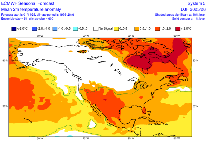
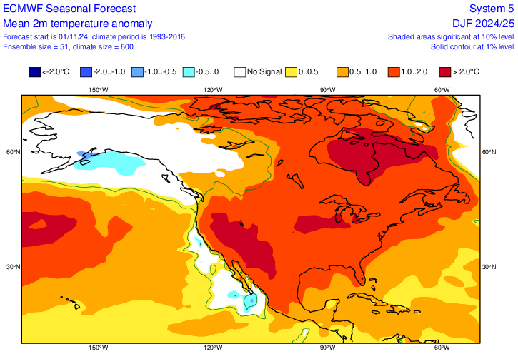
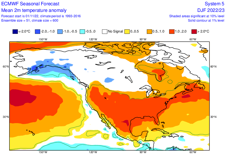
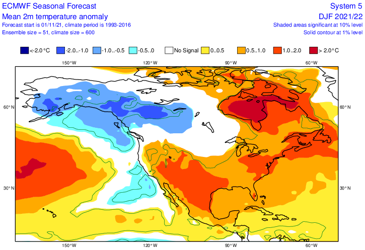
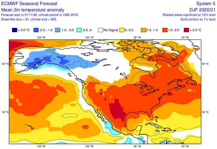
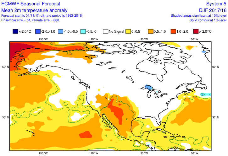
Thanks, Mitch. Of the 6 La Niña Nov forecasts for winter still available at the website, 2025-6 is the second coldest in the E US: 2025-6: 2024-5: significantly warmer than 2025-6 (verified much too warm in E US) 2022-3: moderately warmer than 2025-6 (verified not warm enough) 2021-2: slightly warmer than 2025-6 (verified slightly too warm) 2020-1: significantly warmer than 2025-6 (verified significantly too warm) 2017-8: significantly colder than 2025-6 (verified well) So, regarding the 5 prior Nov Euro La Niña E US winter forecasts, 3 verified too warm, 1 verified well, and 1 verified too cold.
-

Central PA Fall Discussions and Obs
WmsptWx replied to ChescoWx's topic in Upstate New York/Pennsylvania
Car thermometer read 29°F this morning. -
LOL, this ^^
-
 13 10 from ginxy Only 1 verifies
 -
Overnight Wednesday, November 5, 2025 Wind Event
dendrite replied to weatherwiz's topic in New England
The W-NW CAA winds generally are. We can do 45-55mph no problem, but the >55kt stuff is rare. The westerly component doesn’t do as much tree damage either since the trees grow braced against that flow. Give me a mixed down raging easterly LLJ over something this. -
31.2 for the low around 4:30 this morning. A light W/WSW started about that time and temps started slowly going up, currently 33.8/29.1 at 8 am.
-
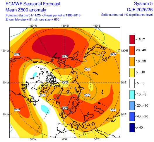
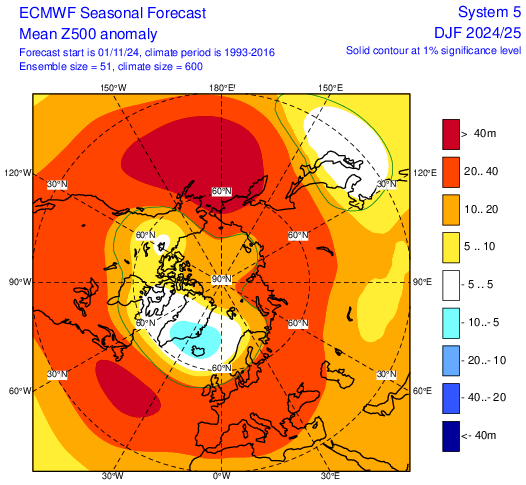
Comparison to this year's 500mb anomaly forecast for DJF and last year (bottom)
-
It'll be slightly AN due to back tland forth pattern.
-
 Models had the low intensifying at a faster pace earlier as it passed through. I'm guessing it'll be sub advisory for most for like 1-2hrs, nothing noteworthy.
- 22 replies
-
- 1
-

-
- wind damage
- power outages
- (and 1 more)
-
Overnight Wednesday, November 5, 2025 Wind Event
Brian5671 replied to weatherwiz's topic in New England
with about half the trees bare now (at least here) 45-50 is not a big deal outside of isolated limbs/trees down -
 Looks like a warm to hot Thanksgiving period
 -
November 2025 general discussions and probable topic derailings ...
dendrite replied to Typhoon Tip's topic in New England
This is more riveting than dew tracking -
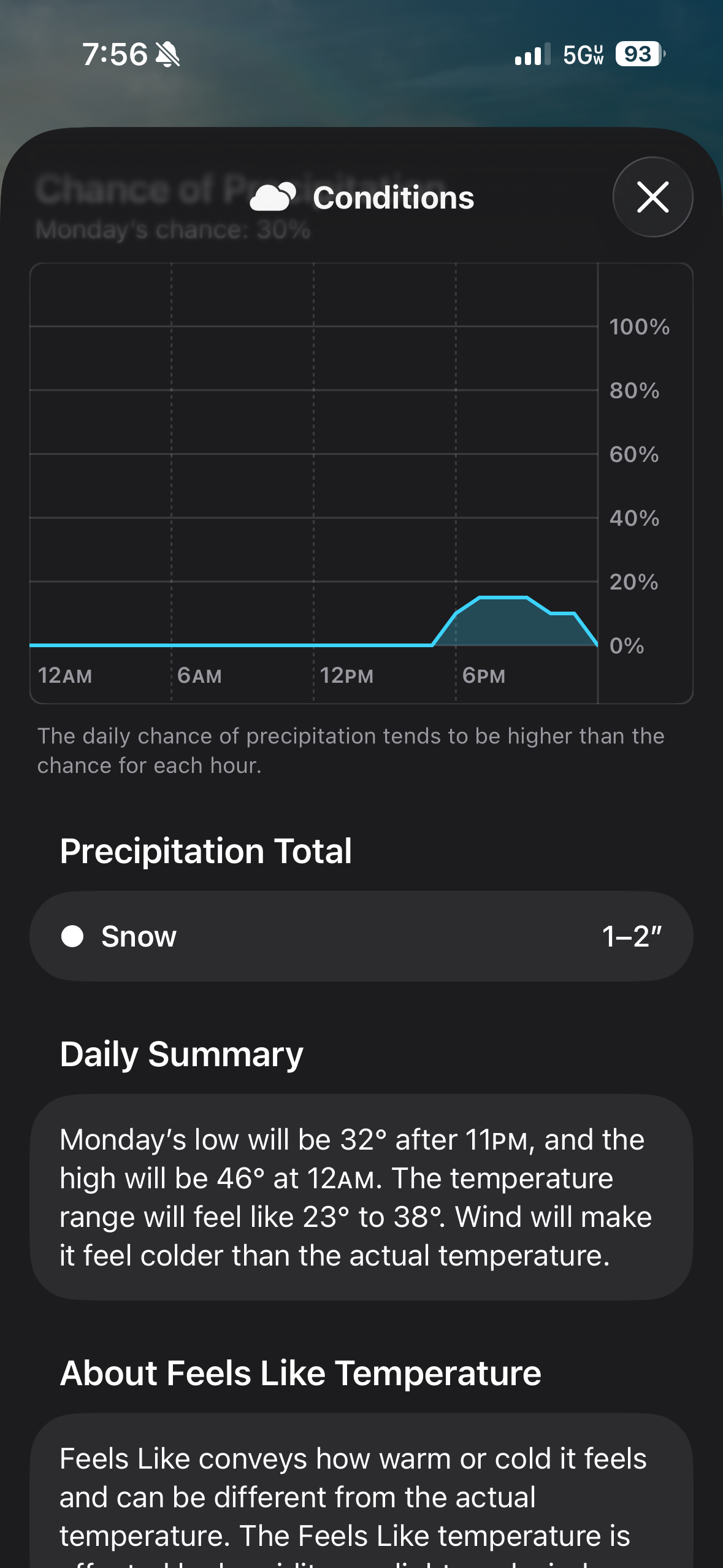
when in doubt, go with the great Apple weather!
-
12z should bring back the 5 mph that 00z lost . Looking solid
-
Here's a link to all the seasonal Euro if interested. https://charts.ecmwf.int/?facets={"Product type"%3A["Experimental%3A AIFS"]%2C"Parameters"%3A[]%2C"Type"%3A[]%2C"Range"%3A["Seasonal"]}