All Activity
- Past hour
-
73/63
-
Yeah - lasted 10-15 minutes. Probably somewhere between .25-.5 inches I'd estimate I think we're in the same town, unless you've moved anytime in the past 10 years or so
-
About 6 weeks later (Mid-July) we were visiting family at DEC and near sunset on Saturday a storm passed maybe 6-8 miles to our south. Most frequent flashes I ever hope to see - 100/minute plus - and the thunder was like a drum roll thanks to distance/frequency. Later that evening another storm dumped 3" at the kids' place in 90 minutes; lots of thunder but nothing like the earlier one. Next morning at church folks were exclaiming about the light show - impressed even the locals.
-

E PA/NJ/DE Spring 2025 Obs/Discussion
RedSky replied to PhiEaglesfan712's topic in Philadelphia Region
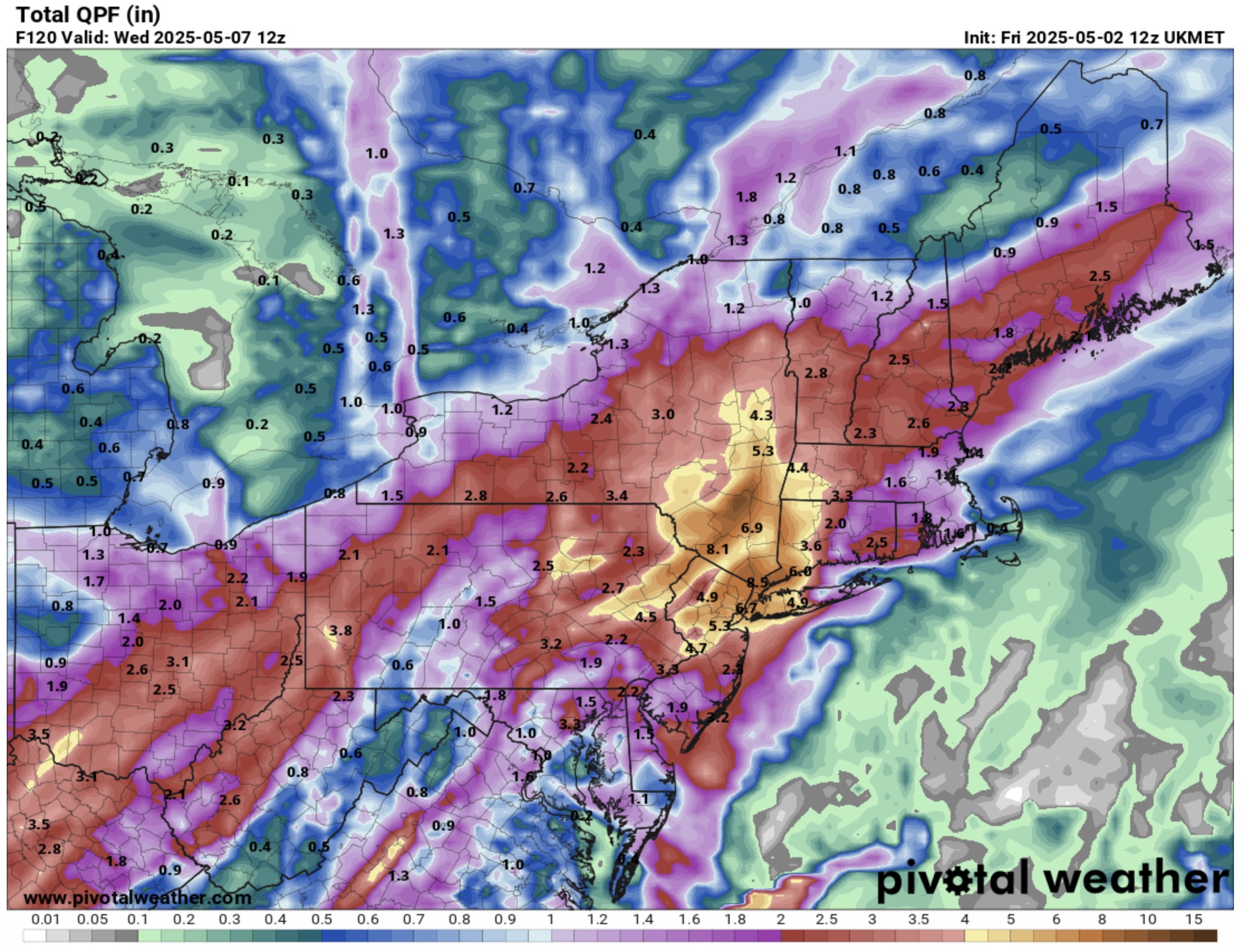
ECM is 1-2" through Monday then an additional 1-1.5" in scattered showers through the 7 day most of that on Tuesday Much improved forecast from a couple days ago now mostly Monday and Tuesday as cloudy and wet -
Fickle evolution. Hopefully the wetter models are right. It won’t cause flooding since the rain comes over a few days and we need to build up the groundwater for summer.
-
-
Rogue cell
-
UKMET haha:
-
It got hot quickly. 81F
-
Ok once in a generation.
-
3.23 since March 1st.. Only May 2nd and grass is already brittle....
-
the only thing that concerns me are reservoir levels they are at 96% with the new forecast looks like the reservoirs will greatly benefit from this rain who knows we might get to 100% or close to it in a week..
-
Pouring in Central NJ right now
-
Should break into the sun within an hour. In the meantime, 52.7° and overcast.
-
6/1/11 and 6/8/11?
-
Euro still very wet

-
HRRR pretty insistent on a storm along MA/NH border later today.
-
Sunny hot and Dewey out there. We wipe, we love
-
Euro also drier. But not gfs bad. Mostly 1-2” with higher spots.
-

2025 Lawns & Gardens Thread. Making Lawns Great Again
Chrisrotary12 replied to Damage In Tolland's topic in New England
I might not mow till June. -
SLGT risk tomorrow for metro areas west to the WV panhandle
-

2024-2025 La Nina
TheClimateChanger replied to George001's topic in Weather Forecasting and Discussion
I think some people are missing out on how much warming has occurred globally since the 1990s. Just look at the UAH temperature data [which uses a 1991-2020 baseline] and the 1990s look as warm globally as the 1800s used to look in the 1980s & 1990s, which to me suggests as much warming occurred in the last 25 years as had occurred in the preceding 100+ years. -
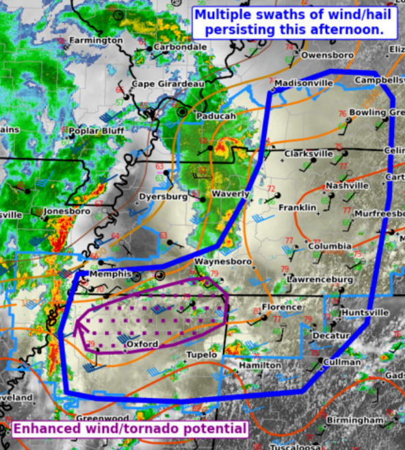
Mesoscale details are flexing in a pattern that acts more like June 2. In fact our lead wave is an MCV from overnight Texas activity. So June. Then outflow boundaries are strewn about. MD #648 keys in on outflow spit out from ongoing thunderstorms approaching Middle Tenn. New line going through Memphis will be able to interact with the said outflow boundary. I also feel like a more diffuse boundary stretches east through North Alabama into North Georgia, attempting to lift north farther east. That boundary could be left over from Thursday evening storms. While it has a couple more hours to destabilize, scattered storms are already developing that way. When the main line gets there it should have a bow shape which favors straight wind over rotation. QLCS spin-up or two might be possible. Otherwise, I think the diffuse boundary just serves to keep storms robust and straight winds strong.
-

E PA/NJ/DE Spring 2025 Obs/Discussion
Kevin Reilly replied to PhiEaglesfan712's topic in Philadelphia Region
So…. Euro had 10” a few days ago and what I’m seeing the percent starts at 90% then drops to 80% the drops to 60% then drops to 40% then drops to 30% then zippo. This has become tracking a winter storm like looking for a needle in a haystack. NWS last night had heavy rain here for 3 days see about that! Guess it depends where the front and storm get stuck. Think someone said a few pages back hope the rain stops by next Saturday! Can’t stop if it doesn’t start. also nice to see the Southeast Ridge Bermuda high in place like it’s mid summer damm lightning bugs brought it I’m sure. -
I still think the 6/1/11 event that evening was the best night show I've ever seen. Just constant flickering and lots of close CGs. My old co-worker who chases in the Plains called it OKC lightning. Said the best he's seen around here. Knocked out power for the Bruins Stanley cup game lol. I think it was game 1.