All Activity
- Past hour
-
Looking at previous El Niño winters, South Bend tends to cash in, in the Spring (yuck). South Bend snow in March and April: 2015-16: 11" 2009-10: 0" 1997-98: 21" 1991-92: 18" 1986-87: 4" 1982-83: 13" 1972-73: 6" 1965-66: 17" 1957-58: 5"
-

2026-2027 Record-breaking El Nino
GaWx replied to Stormchaserchuck1's topic in Weather Forecasting and Discussion
This is just like the strongly E based 1997 was in the first half of Nov, but is unlike the 9 other strong+ ones which had either neutral or -PNA then. -
It's hard to go for much cold with a strong Nino. Even if the SSW were to create strong HLB the strong Nino enhanced Jet may keep the what would be downstream Eastern Trough shunted NE. For the sake of winter weather lover's, let's hope that's not the Case and we get at least a period of wintry wx in what normally would be Nino's warmest Time (late Nov/December). Depending on how fast the Nino fades, we may get lucky late Winter.
-
Just did a readthrough of the old Snowtober threads. Lot of fun! We better get something to track soon(ish), but while this weather is boring, it's also totally fantastic
-
Nothing is fake…but I think we all get the point. Whatever it’s doing in your area/backyard at any given moment isn’t fake.
-
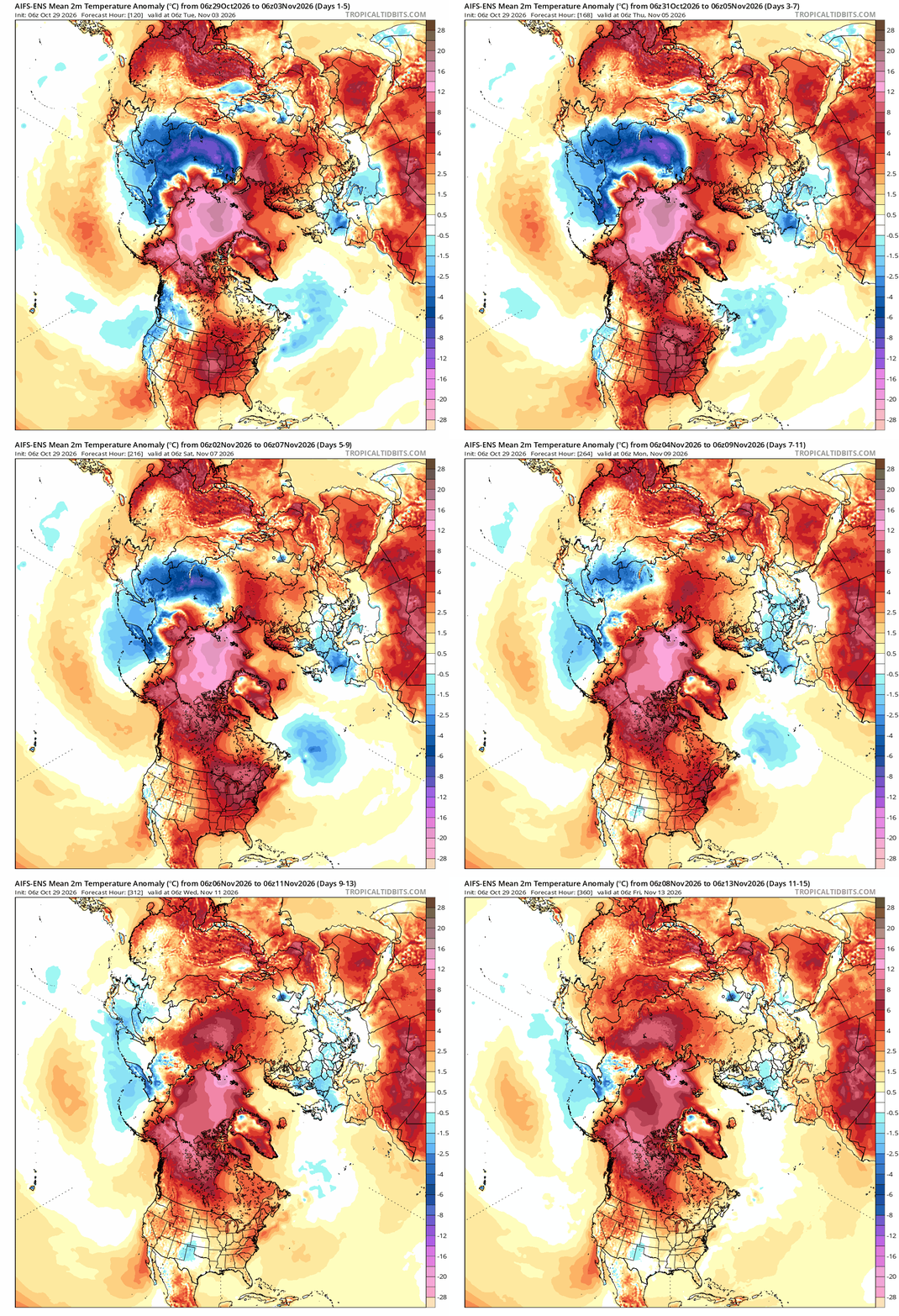
Sorry to hear that Jeff still far out so things could change but fun cold rain on election day yippie (sarcasm) .
-

2026-2027 Record-breaking El Nino
BlizzardWx replied to Stormchaserchuck1's topic in Weather Forecasting and Discussion
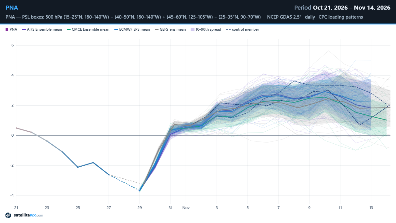
Good agreement on that positive PNA to start out November among all modeling systems. (Yeah I know I need to clean this graphic up a bit but I guess it'll get the job done for today)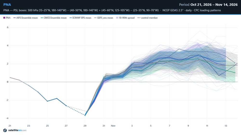
-
Yeah what once looked somewhat promising now looks like trash for thunderstorm fans like me. Probably just cold rain on Election Day. Lovely.
-

E PA/NJ/DE Autumn 2026 Obs/Discussion
The Iceman replied to PhiEaglesfan712's topic in Philadelphia Region
@PhiEaglesfan712you brought up 94-95 in another thread and I spent my lunch break looking into that winter, that is a very good sneaky analog. Not as strong of an el nino but the solar and PDO are pretty good fits. Outside of this storm, it was a pretty bleak winter. Kind of like 2015-2016 though -

2026-2027 Record-breaking El Nino
40/70 Benchmark replied to Stormchaserchuck1's topic in Weather Forecasting and Discussion
Of course it's going to be masked by the strongest El Nino in history in the seasonal mean, the question is whether it portends a favorable stretch of two during the winter, which often makes the difference between a bottom-dwelling winter in terms of snowfall and a middling season. -
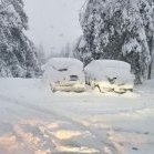
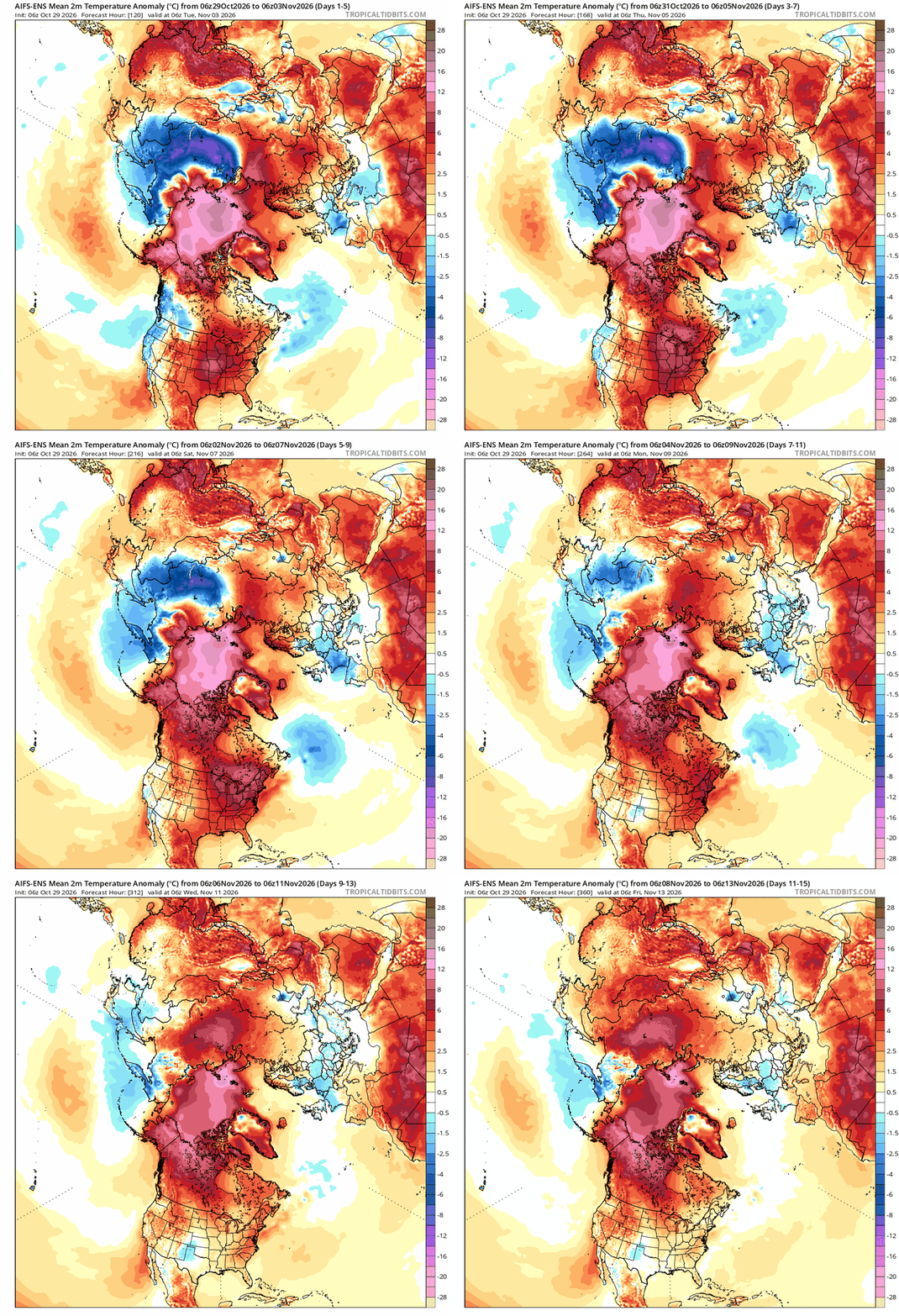
good luck building snowpack with this. ouch
-
Snow above 2kft is fake. @powderfreakwould even agree.
-
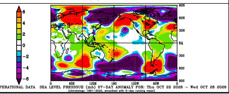
I remain bearish despite SSW talk. First, the signal is better for Europe than it is for NA. Next, we've seen Novembers with such warmings go cold in Europe and keep Eastern US ridge. Couple good X accounts that post more Southeast AmWx had sources (on X). Anyway, I like the warm forecast, so I just liked and scrolled on. Some chatter about Arctic blocking and snow cover came up. Wrong pressure signal though. Eastern Siberia is low press. China is normal. For cold we want China low press and Siberia surface high. That's the cold building. Currently eastern Siberia snow build is not blocking, but storminess. Continue robust Pacific jet. Continue mild Southeast US. Bonus: Scandinavia block could get more bullish for Europe. I hope not for their sake, and because one country keeps bombing civilian heating of another country that way.
-
2026-2027 Record-breaking El Nino
GaWx replied to Stormchaserchuck1's topic in Weather Forecasting and Discussion
Looking at only Ninos of +1.4+ (per RONI), there have been 10 others since 1950 but only one (1997) had a +PNA dominant first half of Nov like GEFS says 2026 is going to have. GEFS is suggesting ~+1.0 (after adjusting downward for bias) for 11/1-15/2026. How does this compare to the other 10 actual 11/1-15? 2023: -0.1 2015: -0.2 2009: -0.3 1997: +1.2 1991: +0.1 1986: -0.9 1982: -0.3 1972: +0.1 1965: -0.5 1957: 0.0 I wonder if this strong early Nov +PNA in 2026 is largely due to how E based it is being that 1997 was so E based early. https://ftp.cpc.ncep.noaa.gov/cwlinks/norm.daily.pna.index.b500101.current.ascii -
You silly. Is Elevated snow fake snow? I mean in that situation…it’s only cold above a certain level.
-
 https://fronteracaredirect.shop/# pharmacia mexico
-
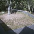
64f. Feels like san diego Sent from my SM-S921U using Tapatalk
-

2026-2027 Record-breaking El Nino
snowman19 replied to Stormchaserchuck1's topic in Weather Forecasting and Discussion
Man, this upcoming WWB for early November looks real impressive on the models. This thing is the energizer bunny in regions 3.4, 3 and 1+2…. -
E PA/NJ/DE Autumn 2026 Obs/Discussion
The Iceman replied to PhiEaglesfan712's topic in Philadelphia Region
I'm far from a pro but the hobbyist in me thinks this winter is going to be a struggle. I think pac air will flood the continent and we struggle to get the cold air necessary for snow. I foresee a lot of cold rain. My guess for SE PA/NJ/DE would be 5 - 10" and most of that in one or two storms that either start as snow or end as snow. Super balls to the wall east based Nino rarely plays out well here. I hope I'm wrong but I'm heading into winter with measured expectations. Euro weeklies looked pretty bleak imo, storm tracks look underneath of us but the continent is flooded with warm pac air. Perfect track rainstorms may be the theme much like 97-98. I do think it'll be wet though so there's a chance snowfall could end up surprising like 2015-2016 if everything comes together in a favorable week or two period(cold air, blocking). I don't see a 6 week hard freeze like last year thats for sure... I think DJF temps averages +2 - +4, precip is above normal, snow below normal. I honestly just hope we don't get skunked again like 19-20 or 22-23. Temps: Dec +1 - +3 Jan +2 - + 4 Feb +3 - +5 Precip: Dec: Above average Jan: Average Feb: Above Average -

2026-2027 Record-breaking El Nino
SnowGoose69 replied to Stormchaserchuck1's topic in Weather Forecasting and Discussion
In recent weeks we have all seen those posts that most El Ninos in recent times the Nov pattern repeated in December...well yeah, probably not gonna happen this time. I'd be surprised if the +PNA/-AO/-NAO pattern dominated December in a +3 El Nino. Obviously the whole PV weakening is what will throw a wrench into the whole history but another case of I think nobody knows what will happen this winter. -
I think he means his grass
-

2026-2027 Record-breaking El Nino
Typhoon Tip replied to Stormchaserchuck1's topic in Weather Forecasting and Discussion
Yeah I'm liking this idea myself as of late. The 70 and 100 hPa level anomalies currently observed may be related. -

2026-2027 Record-breaking El Nino
roardog replied to Stormchaserchuck1's topic in Weather Forecasting and Discussion
I wonder if the recent big jump in Nino 4 anomalies and the +SOI is related. Could easterlies be pulling some of that warm water a little back to the west? -
2026-2027 Record-breaking El Nino
SnowGoose69 replied to Stormchaserchuck1's topic in Weather Forecasting and Discussion
You'd assume based on where the PDO is now and its tendency the last 2 winters from what it WAS on 11/1 to where it translated the remainder of the winter that probably is true. I don't see the PDO going from -0.7 to -1.6 when the last 2 winters in what was more a colder neutral setup it went towards neutral both times. -

2026-2027 Record-breaking El Nino
Terpeast replied to Stormchaserchuck1's topic in Weather Forecasting and Discussion
Another possibility is that the stronger mid latitude ridging (which also contributes to the NW Pac marine heat wave) is behind the strat warming. No science behind this, just speculation.