All Activity
- Past hour
-
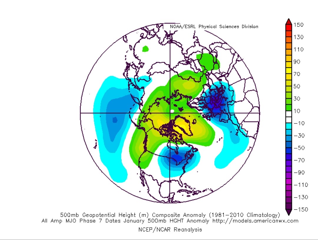
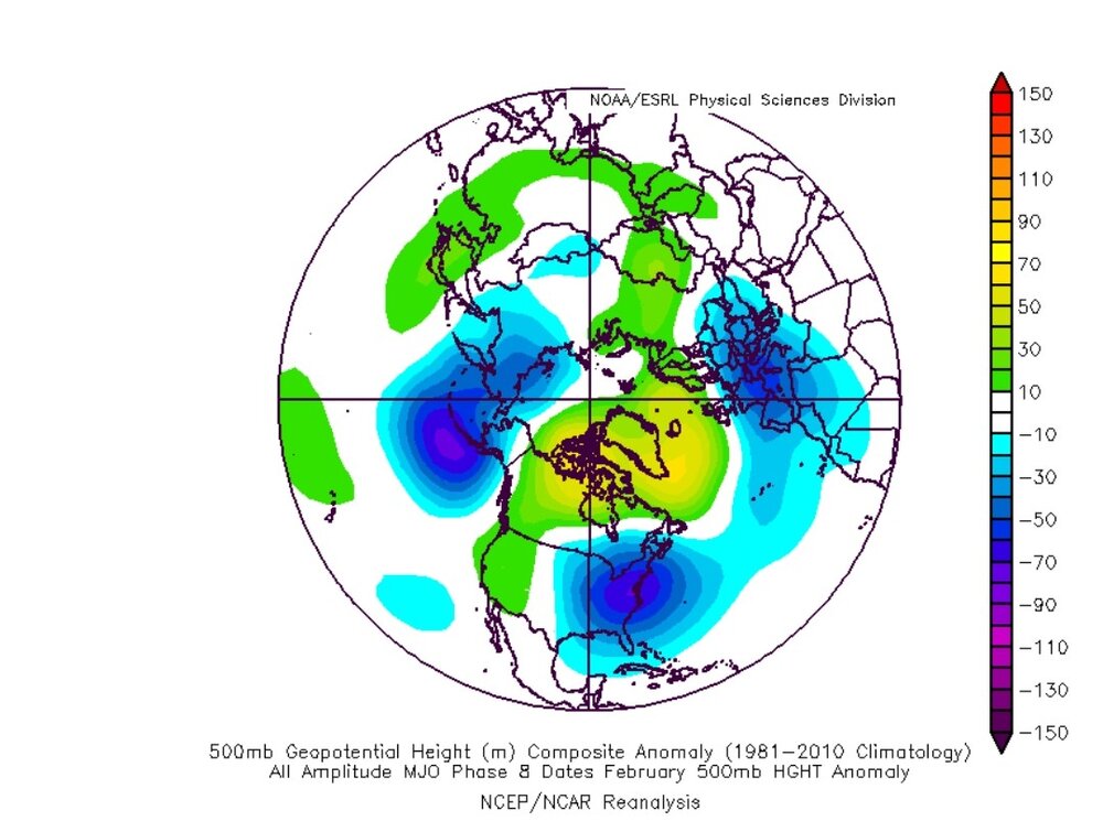
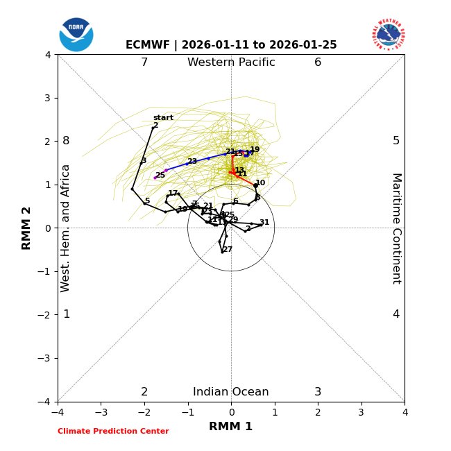
MJO phase 7-8, January analogs

-

Pittsburgh/Western PA WINTER ‘25/‘26
colonel717 replied to Burghblizz's topic in Upstate New York/Pennsylvania
-
Gonna get ahead of the game by reminding everyone to be thankful it’s 45° and raining and we’re avoiding early heat as long as possible
-
MRX disco from this afternoon... National Weather Service Morristown TN 1240 PM EST Tue Jan 13 2026 ...New DISCUSSION, AVIATION... .KEY MESSAGES... Updated at 1233 PM EST Tue Jan 13 2026 - Significant Accumulating snow is likely across the higher elevations, with lighter accumulations (dusting to 1/2 inch) for the Plateau and valley from late Wednesday afternoon/evening through Thursday morning. - Additional snow showers will be possible this weekend, especially over the higher elevations. && .DISCUSSION... Issued at 1233 PM EST Tue Jan 13 2026 The main concern for the next several days is the potential for snowfall Wednesday into Thursday. Thus the discussion will largely focus on the potential of snow during that time-frame. For Tonight, surface ridging will give way to increasing bounday layer southwest winds. Sky will be mostly clear in the evening with increasing clouds toward sunrise. Overall, another good radiational cooling night and have lowered mins below NBM guidance. For Wednesday through Thursday, a deepening upper trough across the eastern United States will produce widespread precipitation. For Wednesday, a strong 300mb jet of 120-130 knots over the eastern Ohio valley will place the area under the favored right entrance region. This jet structure will enhance a frontal boundary moving across the area during the afternoon and evening. Strong fronto-genetic forcing is noted around 00Z tightening the thermal gradient along this boundary. Initially widespread rain band will spread across the region associated with the baroclinic band. Vertical temperature profile quickly cools off due to the forcing with the snow level dropping quickly. The higher elevations will see snow by 3 to 4 pm, then snow levels dropping. The dendritic growth zone will be favorable around 00Z then moisture levels become more shallow. REFS shows 60-70 percent probabilities of 4 inch or more across the highest elevations but most of the higher terrain will see 2 to 4 inches across the far east Tennessee mountains with 1 to 3 inches across southwest Virginia mountains. We have issued a winter weather advisory for these areas from 3 pm Wednesday through 11 am Thursday. REFS does show 30 to 50 probabilities of dusting to 1/2 inch (possibly 1 inch higher ridges) across the Plateau and lower elevations of southwest Virginia and northeast Tennessee. Plan on issuing a SPS to message this possibility. Due to orographic lift and cold air squeezing out left over moisture have continued chance of shower showers (high elevations) and flurries for the lower terrain through much of Thursday morning. For Thursday night and Friday, upper trough has moved east of the area with another system moving across the Great Lakes and Ohio valley. The forcing with this system looks to stay north of the area. Milder temperatures and dry conditions expected. with surface ridging. Another deep upper trough digs into the Ohio valley for Friday night and Saturday. A series of short-waves will move across the region producing occasional mixture of rain and snow. Ensemble clusters show varying solutions with this system thus the confidence is low. &&
-
Special Wx Statement from MRX... Special Weather Statement National Weather Service Morristown TN 154 PM EST Tue Jan 13 2026 TNZ012>017-035>040-042-044-046-069>071-073-VAZ001-005-008-140900- Scott TN-Campbell-Claiborne-Hancock-Hawkins-Sullivan-Morgan- Anderson-Union-Grainger-Hamblen-Northwest Cocke-Northwest Greene- Washington TN-Northwest Carter-Knox-Jefferson-Northwest Blount- North Sevier-Lee-Scott VA-Washington VA- Including the cities of Big South Fork National, Oneida, Smokey Junction, Elgin, Huntsville, Norma, Slick Rock, Fincastle, La Follette, Elk Valley, Jellico, White Oak, Caryville, Royal Blue, Lone Mountain, Sandlick, Springdale, Arthur, Harrogate-Shawanee, Clairfield, Howard Quarter, Evanston, Sneedville, Treadway, Kyles Ford, Mooresburg, Kingsport, Bristol TN, South Holston Dam, Pine Orchard, High Point, Petros, Oak Ridge, Clinton, Maynardville, Norris Lake, Paulette, Rose Hill, Sharps Chapel, Luttrell, Bean Station, Alpha, Morristown, Russellville, Bybee, Newport, Greeneville, Johnson City, Elizabethton, Bearden, Knoxville, Lake Forest, Jefferson City, Strawberry Plains, Chestnut Hill, Dandridge, White Pine, Happy Valley, Maryville, Alcoa, Harrisburg, Kodak, McMahan, Sevierville, Seymour, Pigeon Forge, Hiltons, Benhams, Bristol VA, and Abingdon 154 PM EST Tue Jan 13 2026 ...Rain Changing to Snow Late Wednesday Afternoon and Evening... A cold front will move across east Tennessee, southwest Virginia, and southwest North Carolina late Wednesday afternoon and evening bring with it widespread precipitation and colder temperatures. A band of rain will move into the region then mix with and change over to snow by early evening. A brief period of accumulating snow is possible across the Plateau, southwest Virginia, northeast Tennessee, and central valley. Snowfall of 1/2 inch is possible mainly on grassy and elevated surfaces, and up to 1 inch across the higher ridges. Snow covered roadways are possible across the higher terrain Wednesday evening. Stay tuned to NOAA Weather Radio and other local media for further details or updates. $$
-
Is cold air ever guaranteed at 41° N and 74° W? I count 3 separate rain events in the LR on both the GFS and ECMWF. In January that can't be that cold. No we don't forecast based on LR OP model runs. But it's risky to guarentee something in the face of directly contradictory evidence.
-

January 2026 Medium/Long Range Discussion
NorthArlington101 replied to snowfan's topic in Mid Atlantic
Only 240-300 hours out... what could possibly go wrong? -
Get this guy out of here
-
The 12z GEFS and GEPS(and prior runs) have roughly 6" of snow for their NE TN ensemble means. Usually, that is a good sign. No idea if those numbers will verify, but I am optimistic that we see some winter weather over the next couple of weeks.
-
Pittsburgh/Western PA WINTER ‘25/‘26
colonel717 replied to Burghblizz's topic in Upstate New York/Pennsylvania
-
I can't speak for everyone but I suspect if asked today, most would be happy with an average Feb & March even if they finished below normal for the season.
-
Still to far out and will likely change. Snow showers this weekend for us here Felton disappeared as the system gets pushed OTS. Kick the can all the way to winter 2026-2027. Lol
-
Here are the full run ensemble clown map members...
-
He gone!
-
Pulled the trigger on a trip up to DCL Thurs-Sun... Euro calling for 6", GFS calling for 9". Need some snow in my life.
-
100% Agree. Bone chilling cold with no snow sucks.
-
For Stelwagon or Flemish Cap?
-
Get out

-
At least it's coming after dark......... silver lining i suppose. lol
-
Nah if it’s not snowing it can be warm
-

January 2026 regional war/obs/disco thread
powderfreak replied to Baroclinic Zone's topic in New England
But that doesn’t mean there can’t be region-wide fun winter events though still to come too. -
That's a shame honestly. If the trough axis was focus over the Ohio Valley, we'd have the door open for disturbances to shoot up the coast. At least it's cold. There's nothing worse than 55 and sunny in winter.
-
The 12z GEM para is again the model which I "think" simulates the next ten days in a sensible fashion. As Boone noted, lots of light events are embedded. Systems don't look overly amped, but looks sensible in terms of its QPF and track given cold air in place. This is what "should" be occurring at the base of a highly amplified trough. Beginning the 17th, there are several small events which rotate through.
-
Are you really this stupid ? Show me proof . Go ahead.
-
For what exactly? Still looked like to me