All Activity
- Past hour
-
Beautiful weekend to me
-

Central PA Spring 2026 Discussion/Obs Thread
Voyager replied to Voyager's topic in Upstate New York/Pennsylvania
I want to try yard saling. What kind of boat should I get? -
The totals on the above map in Fallston of between 2 and 3 inches is right for the farm. We are probably around 2.4” with whatever has fallen this AM adding to it. That 3.5” over in Edgewood is reflective of the weird storm approach on Thursday to Fallston that fell apart and re-formed just past Fallston and unloaded on 95. SUPER glad for the last 60 hours of rain at the farm - hugely beneficial and hugely needed at a critical juncture as we’ve been getting flowers into the fields in the previous weeks…
-
Narrow band set up shop over head this morning bringing the total to 4.89" thus far. @MillvilleWx I've thought all along what an incredible snowstorm this would have been. Imagine our thunderous squall we experienced yet for several hours at a time. Yes, please and thank you I'll take another lol.
-

2026-2027 Strong/Super El Nino
GaWx replied to Stormchaserchuck1's topic in Weather Forecasting and Discussion
The latest weekly BoM, which just extended to Nov for the first time, is forecasting a +2.9C RONI in SON. The record back to 1950 is +2.5C (1982). However, caution on the ultimate strength is advised due to warm bias: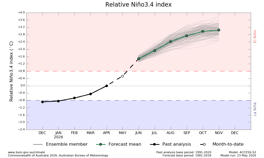
-
Rain finally moving out-can salvage some of today but wow what an awful 3 day weekend
-
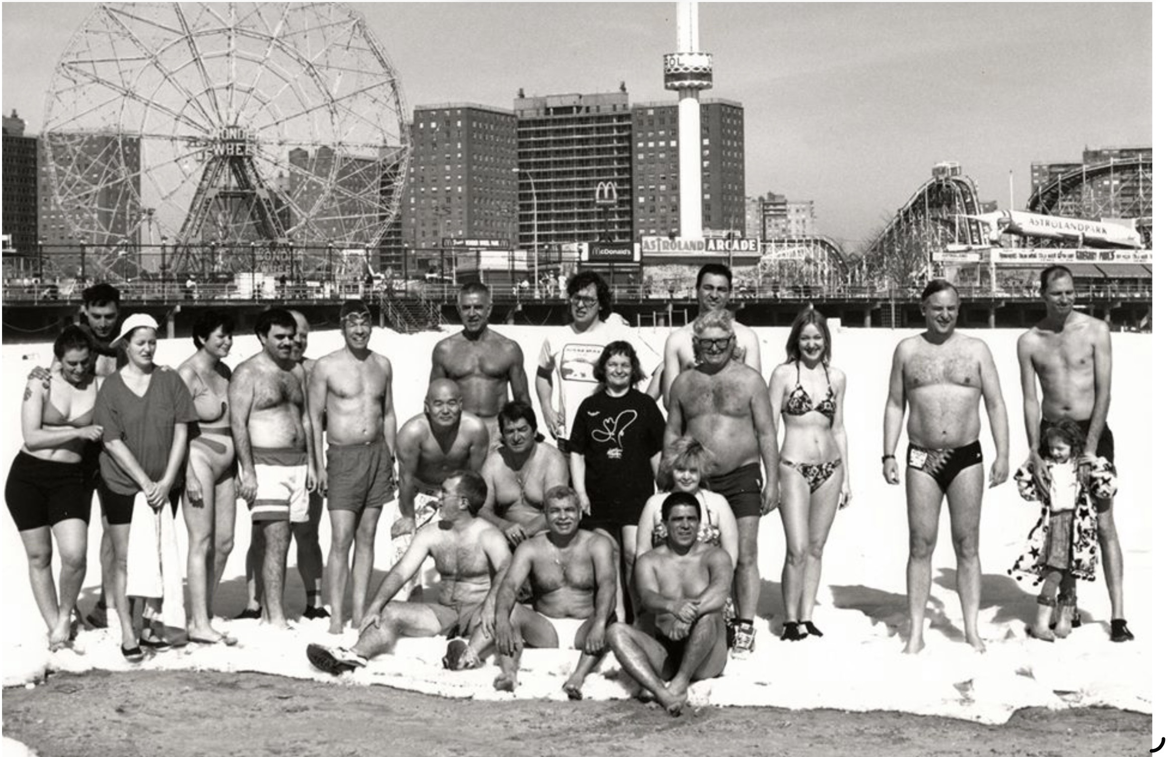
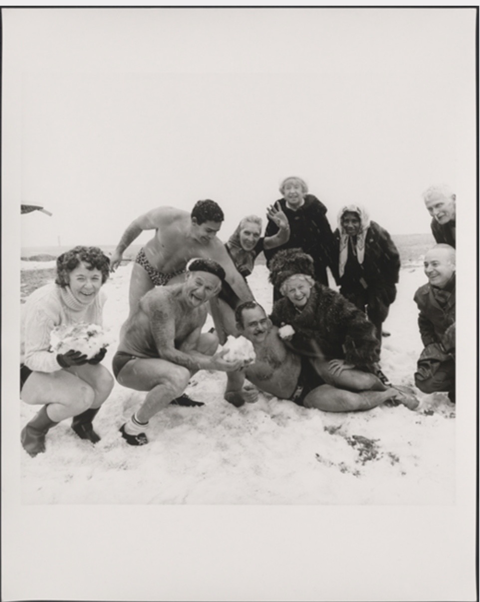
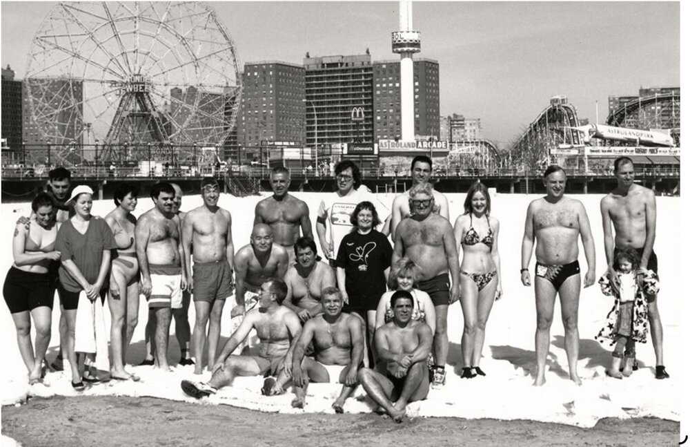
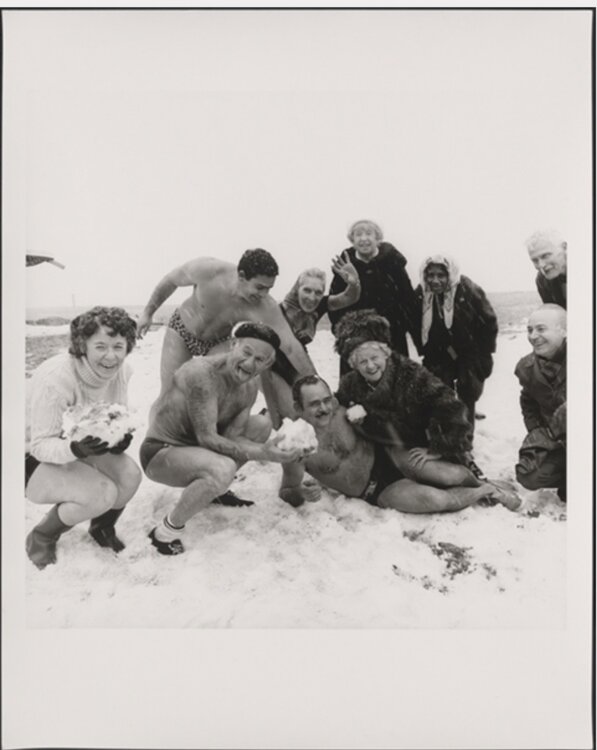
I remember the annual plunge of Brooklyns, Comey Island, Polar Bear Club. In a deep stretch of cold and sometimes with snow on the beach they would make their beach plunge. Newsprint and TV news would cover it. As you can see they were average folk but when I was asked for a comment way back, in my younger days I said “ definitely certifiable” now, perhaps, I’m not so sure. Stay well everyone, as always …..


-
Just dumping here.....holy crap
-
(002).thumb.png.6e3d9d46bca5fe41aab7a74871dd8af8.png)
Central PA Spring 2026 Discussion/Obs Thread
ChescoWx replied to Voyager's topic in Upstate New York/Pennsylvania
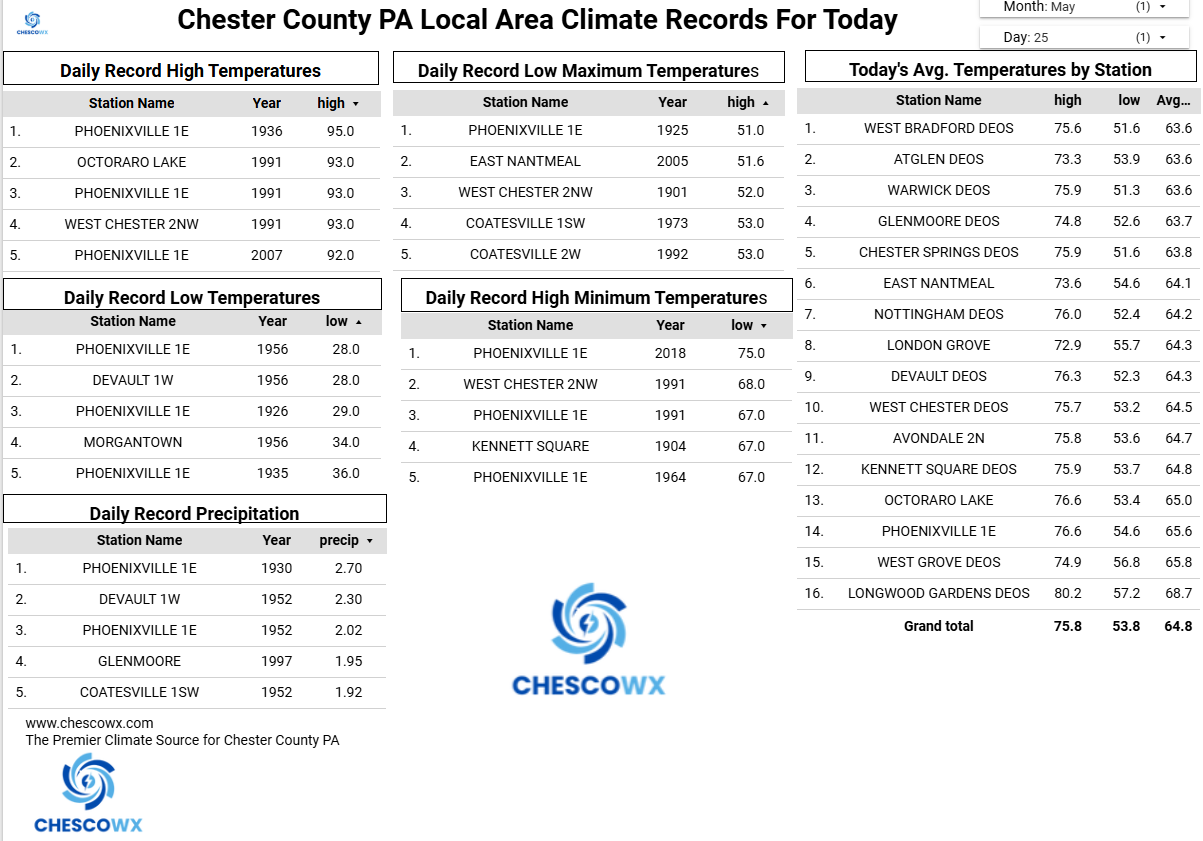
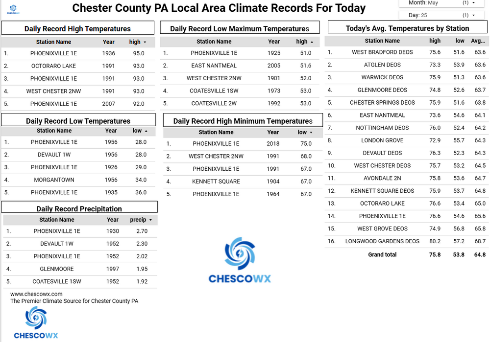
Happy Memorial Day and thank you to those who serve our country. Still some showers around today before we finally see a return of the sun tomorrow. Temperatures both tomorrow and Wednesday will be several degrees above normal with highs not far from 80 degrees. We then see a return of cooler than normal temperatures but with mostly sunny days right through next weekend.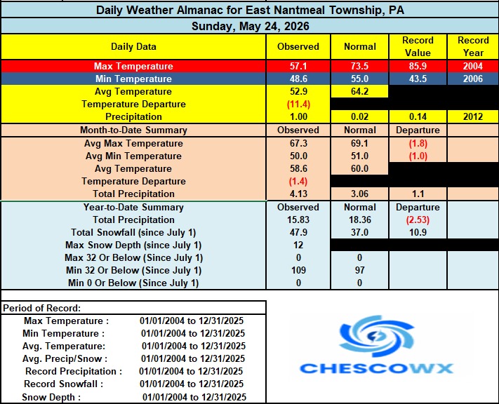
-
E PA/NJ/DE Spring 2026 Obs/Discussion
ChescoWx replied to PhiEaglesfan712's topic in Philadelphia Region
Happy Memorial Day and thank you to those who serve our country. Still some showers around today before we finally see a return of the sun tomorrow. Temperatures both tomorrow and Wednesday will be several degrees above normal with highs not far from 80 degrees. We then see a return of cooler than normal temperatures but with mostly sunny days right through next weekend.
-
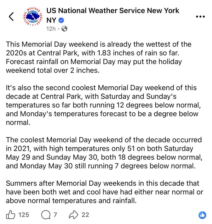
Well to be fair, my POP was really high, and I did indeed get rain. Just not very much of it.
-
-
I got just a T the last 24 hours and am at only ~1.5” MTD with most of that falling 23 days ago!
-
Just drove 340 between Brunswick and Frederick. Patchy dense fog. Careful driving this am.
-
Records: Highs: EWR: 93 (1991) NYC: 95 (1880) LGA: 95 (2007) JFK: 91 (1991) Lows: EWR: 42 (1956) NYC: 41 (1925) LGA: 44 (1967) JFK: 41 (1967) Historical: 1837: Vicksburg, MS had a series of frosts, "which were extraordinary" for this time of year. (Ref. Wilson Wx. History) 1859: A child was reportedly sucked up by a waterspout at Iowa City, IA and blown 500 yards, but miraculously survived the ordeal. (Ref. Wilson Wx. History) 1880: Record maximum temperature for Washington DC. for the date is 94 °F.(Ref. Washington Weather Records - KDCA) An estimated F2 tornado moved northeast through the town of Mitchell, SD. Two men were killed when they ran out the back door of a saloon in order to reach the cellar entrance. The Caulk Stone Saloon was destroyed along with two homes and several businesses. This tornado was one of the first significant tornadoes on record for the state of South Dakota. (Ref. Wilson Wx. History) 1896: An estimated F5 tornado hit Oakwood, Ortonville, and Thomas, Michigan. Forty-seven people were killed, and 100 were injured. Trees were debarked "even to the twigs, as though done by the careful hand of an experienced artisan." Parts of houses were found up to 12 miles away. 1917 - A tornado ripped through southeast Kansas, traveling 65 mph. The average speed was a record for any tornado. (The Weather Channel) 1920: Fussen, Bavaria Germany recorded 4.96 inches of rain in just 8 minutes to set the world’s rainfall record for that length of time. (Ref. Wilson Wx. History) 1955 - Two tornadoes struck the town of Blackwell, OK, within a few minutes time during the late evening. The tornadoes killed 18 persons and injured more than 500 others. Early the next morning a tornado virtually obliterated the small community of Udall KS killing 80 persons and injuring 270 persons. More than half the persons in the community were killed or injured by the tornado. (David Ludlum) (The Weather Channel) 1967: Boston, Massachusetts recorded destructive winds with a peak gust of 70 mph. 1967: A slow moving nor'easter battered New England with high winds, heavy rain, and record late season snow from this date into the 26th. Boston, MA reported a wind gust of 70 mph. Wind gusts of 70 to 90 mph occurred along the coast. Severe damage occurred from very high tides. Over 7 inches of rain fell at Nantucket, MA with 6.57 inches falling in 24 hours to set a new 24 hour rainfall record. 24.9 inches of snow fell at Mt. Washington, NH to set a new May snowfall record. 10 inches of snow fell near Keene, NH and 6 inches was recorded at Dublin, NH. (Ref. Wilson Wx. History) 1975: On Raccoon Lake, Indiana, lightning struck the motor of a speedboat and traveled up the control wires, killing the driver. The 38-year-old man was knocked into the water by the bolt. His wife and two children, also in the boat, were not injured. 1980: A severe thunderstorm crossed the southern part of Knox County in northern Texas. The storm mainly affected the community of Munday, and to a lesser extent, Knox City. The storm produced hail up to softball size and an incredible 4 to 10 inches of rain. On this date through the 26th, a severe weather outbreak occurred across the state of Florida with wind gusts over 50 mph and many sections with reports of winds 75 to 80 mph. Nine tornadoes were reported across Manatee, Dade, Alachua, Suwannee, Marion, Hendry, Charlotte, Lee, and Monroe counties and funnel clouds were sighted in practically every section of the state. The Coast Guard reported that 39 boats capsized along the lower southwest Florida coast alone during the weekend between Gasparilla and Marco Island. It was miraculous that only one death and no serious injuries were reported in Florida. (Ref. Wilson Wx. History) 1987 - Thunderstorms spawned fifteen tornadoes in West Texas. One thunderstorm spawned a powerful tornado near Gruver, TX, along with golf ball size hail and 75 mph winds. A man on a boat on Lake Bistineau in northwest Louisiana was struck and killed by lightning, while the other three persons in the boat were unharmed. The man reportedly stood up in the boat and asked to be struck by lightning. (The National Weather Summary) (Storm Data) 1988 - Unseasonably cool weather prevailed in the Upper Midwest. Marquette, MI, reported a record low of 26 degrees. Thunderstorms in the north central U.S. produced wind gusts to 62 mph at Idaho Falls, ID, and produced 4 inches of rain in less than four hours in northern Buffalo County. (The National Weather Summary) (Storm Data) 1989 - Thunderstorms developing ahead of a strong cold front produced severe weather from Oklahoma to Ohio through the day and night. Thunderstorms spawned nine tornadoes, and there were 155 reports of large hail and damaging winds. Hail three and a half inches in diameter was reported at Dittmer, MO, and thunderstorm winds gusting to 90 MPH caused twenty million dollars damage at Rockville IN. (The National Weather Summary) (Storm Data) 1990 - Evening thunderstorms spawned four tornadoes in Kansas and Missouri, and there were three dozen reports of large hail or damaging winds. Thunderstorms produced hail two inches in diameter at Cole Camp, and wind gusts to 72 mph at Rosebud. Heavy thunderstorm rains produced flash flooding in central Missouri. Flood waters swept through Washington State Park southwest of Saint Louis, and nearly one hundred persons had to be rescued from water as much as twenty feet deep. The flood waters swept away a number of vehicles, some were carried as much as four miles away. (The National Weather Summary) (Storm Data) 1991: Hot weather prevailed across the Mid-Atlantic States. Philadelphia, PA recorded 96°, making it the sixth 90-degree reading in the month, which set a record. There would be a dozen 90-degree days in the month. Baltimore, MD hit 94° and Dulles Airport at Sterling, VA hit 92° to set record highs for the date. (Ref. Wilson Wx. History) 1992: Chicago, IL dropped to 32°, making this the latest springtime freeze on record besting the previous latest freeze on 5/14/1895. Widespread freezing temperatures do heavy damage to the fruit crop across southwest Lower Michigan. Record lows for today included: Lansing: 29°, Grand Rapids: 31° and Muskegon: 32°. (Ref. Wilson Wx. History) 1994: Henrico County: a 26-year-old male died when he took refuge from a thunderstorm under a tree on a golf course. (Ref. Lightning - Virginia Weather History) 1995: A woman carrying an umbrella was struck outside a high school in Winchester while walking to her car. She suffered first degree burns on her left hand where the lightning came down the umbrella and entered her body and on her right foot where the lightning left her body and entered the ground. (Ref. Lightning - Virginia Weather History) 2008: A rare, large and destructive EF5 tornado created a 43-mile long path across Butler and Black Hawk counties in Iowa. This tornado killed eight people, injured dozens and caused several millions of dollars in damage. The tornado was nearly three-quarters of a mile wide as it moved through the southern end of Parkersburg. A third of the town was affected by devastating damage with nearly 200 homes destroyed. This storm produced the first EF5 tornado in Iowa since 6/13/1976 and only the third EF5 tornado to occur in the United States in the past ten years. 2010: Later in the month, winter made another appearance in the West, with cold and snow crossing the region during May 19-25. On May 25, Salt Lake City measured its latest snow ever. The cool, snowy spring in the West provided ski areas with an extended season. Snowbird in Utah, for example, kept its lifts running into the second weekend of June. (Ref. Weatherwise U.S. Weather Highlights of 2010 page 6 )
-
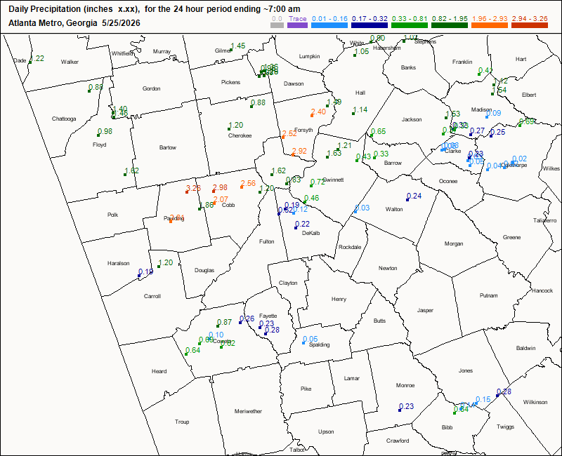
A band from Carrollton to Gainesville, which includes much of the N ATL metro, as well as to the N and NE of AHN centered on Madison county, did quite well the last 24 hours. As the map shows, some other areas of N GA, including near Rome, also did well:
-
Little over 7” so far for the event.
-
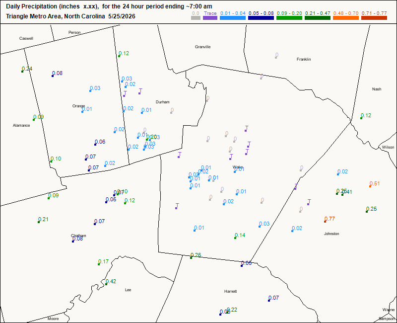
Parts of Johnston county have been the RDU metro jackpot winners of the last 96 hours overall with 1.5”-2”. Here’s the last 24 hours: only they got significant amounts
-
59 / 58 the misery continues for those who enjoy some dry / sunny warm weather this time of year. We'll see how much breaks in the clouds and any sun we can get later today and looking better Tuesday but a bit cloudy albeit warmer Wed. Omega - like trough coastas ridge center persists next cut off is Fri - Sun this coming week (still may see a trend unsettled/rainer)and weekend then ridging will push east 6/4 and beyond. 5/25 : Last day of the Memorial Day crapfest 5/26 - 5/28 : Near normal 5/29 - 6/2 : Below normal cut off 5/30-5/31, trough onshore flow 6/1 6/4 - Beyond : Ridge pushes east moderation to warmer / much warmer and next chance of heat
-
For the snowflakes out there. Pathetic huh. Lol.
-
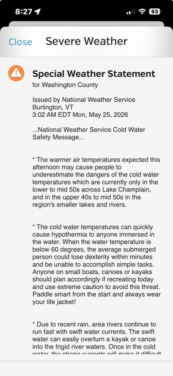
Is this really necessary?
-
yep 2021 Year Date Weekend Day High (°F) Low (°F) Rainfall 2001 May 25, 2001 Friday 57 53 0.04 2001 May 26, 2001 Saturday 64 53 0.06 2001 May 27, 2001 Sunday 70 57 0.08 2001 May 28, 2001 Memorial Day 72 57 0.05 2002 May 24, 2002 Friday 83 56 0 2002 May 25, 2002 Saturday 71 56 0 2002 May 26, 2002 Sunday 69 56 0 2002 May 27, 2002 Memorial Day 77 59 0 2003 May 23, 2003 Friday 56 50 0.15 2003 May 24, 2003 Saturday 56 51 0.09 2003 May 25, 2003 Sunday 62 53 0.01 2003 May 26, 2003 Memorial Day 56 51 1.28 2004 May 28, 2004 Friday 77 62 0.39 2004 May 29, 2004 Saturday 66 54 0 2004 May 30, 2004 Sunday 73 51 0 2004 May 31, 2004 Memorial Day 64 57 0.22 2005 May 27, 2005 Friday 79 56 Trace 2005 May 28, 2005 Saturday 79 57 0.15 2005 May 29, 2005 Sunday 75 54 0 2005 May 30, 2005 Memorial Day 75 57 Trace 2006 May 26, 2006 Friday 74 59 0.24 2006 May 27, 2006 Saturday 83 64 0.01 2006 May 28, 2006 Sunday 83 66 0 2006 May 29, 2006 Memorial Day 88 66 0.01 2007 May 25, 2007 Friday 90 64 0 2007 May 26, 2007 Saturday 85 71 0 2007 May 27, 2007 Sunday 86 66 0.03 2007 May 28, 2007 Memorial Day 83 67 Trace 2008 May 23, 2008 Friday 69 49 0 2008 May 24, 2008 Saturday 71 53 0 2008 May 25, 2008 Sunday 77 53 0 2008 May 26, 2008 Memorial Day 80 58 0 2009 May 22, 2009 Friday 84 62 0 2009 May 23, 2009 Saturday 73 60 0 2009 May 24, 2009 Sunday 83 60 0 2009 May 25, 2009 Memorial Day 81 63 0 2010 May 28, 2010 Friday 70 56 0 2010 May 29, 2010 Saturday 77 61 0 2010 May 30, 2010 Sunday 84 67 0 2010 May 31, 2010 Memorial Day 86 69 0 2011 May 27, 2011 Friday 83 65 0 2011 May 28, 2011 Saturday 84 67 0 2011 May 29, 2011 Sunday 82 67 0 2011 May 30, 2011 Memorial Day 86 70 0.29 2012 May 25, 2012 Friday 75 60 Trace 2012 May 26, 2012 Saturday 84 67 0.02 2012 May 27, 2012 Sunday 81 64 0.06 2012 May 28, 2012 Memorial Day 89 71 0 2013 May 24, 2013 Friday 65 45 0.3 2013 May 25, 2013 Saturday 54 45 0.14 2013 May 26, 2013 Sunday 66 48 0 2013 May 27, 2013 Memorial Day 73 51 0 2014 May 23, 2014 Friday 71 56 0.91 2014 May 24, 2014 Saturday 70 57 0.4 2014 May 25, 2014 Sunday 80 55 0 2014 May 26, 2014 Memorial Day 86 66 0 2015 May 22, 2015 Friday 74 55 0 2015 May 23, 2015 Saturday 70 49 0 2015 May 24, 2015 Sunday 81 56 0 2015 May 25, 2015 Memorial Day 85 64 0 2016 May 27, 2016 Friday 87 73 0 2016 May 28, 2016 Saturday 92 71 0 2016 May 29, 2016 Sunday 87 70 Trace 2016 May 30, 2016 Memorial Day 82 68 1.65 2017 May 26, 2017 Friday 73 56 0.1 2017 May 27, 2017 Saturday 71 59 0 2017 May 28, 2017 Sunday 71 58 0 2017 May 29, 2017 Memorial Day 61 56 0.13 2018 May 25, 2018 Friday 86 65 0 2018 May 26, 2018 Saturday 89 72 0 2018 May 27, 2018 Sunday 80 56 0.44 2018 May 28, 2018 Memorial Day 69 56 0 2019 May 24, 2019 Friday 73 61 0 2019 May 25, 2019 Saturday 71 55 0 2019 May 26, 2019 Sunday 86 59 0.2 2019 May 27, 2019 Memorial Day 80 64 0 2020 May 22, 2020 Friday 77 54 0.03 2020 May 23, 2020 Saturday 67 55 0.65 2020 May 24, 2020 Sunday 67 52 0 2020 May 25, 2020 Memorial Day 71 55 0 2021 May 28, 2021 Friday 69 49 1.22 2021 May 29, 2021 Saturday 51 47 0.46 2021 May 30, 2021 Sunday 51 47 0.89 2021 May 31, 2021 Memorial Day 70 49 0.02 2022 May 27, 2022 Friday 80 65 0.27 2022 May 28, 2022 Saturday 74 63 0.72 2022 May 29, 2022 Sunday 77 59 0 2022 May 30, 2022 Memorial Day 84 63 0 2023 May 26, 2023 Friday 72 53 0 2023 May 27, 2023 Saturday 78 56 0 2023 May 28, 2023 Sunday 79 59 0 2023 May 29, 2023 Memorial Day 79 59 0 2024 May 24, 2024 Friday 84 68 0 2024 May 25, 2024 Saturday 81 66 0 2024 May 26, 2024 Sunday 82 65 Trace 2024 May 27, 2024 Memorial Day 73 66 0.96 2025 May 23, 2025 Friday 63 47 0.26 2025 May 24, 2025 Saturday 64 48 Trace 2025 May 25, 2025 Sunday 66 52 0 2025 May 26, 2025 Memorial Day 73 52 0
-

Central PA Spring 2026 Discussion/Obs Thread
Blizzard of 93 replied to Voyager's topic in Upstate New York/Pennsylvania
In other news, it’s still freaking raining… CTP discussion says it all depends on where the front sets up that will determine how much more rain south of I-80 will get over the next couple of days. I am ready for some sun… -
0.2” today so far but just getting into the heavy stuff.
-
Rebuild in the front office and coaching.


.thumb.JPG.418e8a9a2902ae687ec35ff4bc0e038e.JPG)