All Activity
- Past hour
-
Hope you all don't me me starting a thread on this. As a layman weather enthusiast, and a "visual person", one of my go-to things for getting a good feel for the weather coming was a "radar forecast" loop that was created from the NAM, and posted here: http://hp5-dev.wright-weather.com/nam-conus-radar-loop_1hour.gif As of February it stopped being updated though - the last one was Feb 24th. That website doesn't even exist as a site anymore - my guess is the creation and posting of that gif had been automated many years ago and it just wasn't being maintained, and something along the chain of automation was taken offline or broke on that day. Anyone know if such a thing is created and posted anywhere? (I'm sure the pros on here view that as an amateurish thing, but it actually seemed to be fairly accurate from what I could tell; certainly more useful than not having anything, and more useful to me at least than static maps)
-

Central PA Spring 2026 Discussion/Obs Thread
Jns2183 replied to Voyager's topic in Upstate New York/Pennsylvania
I guess I should add York. Sent from my SM-S731U using Tapatalk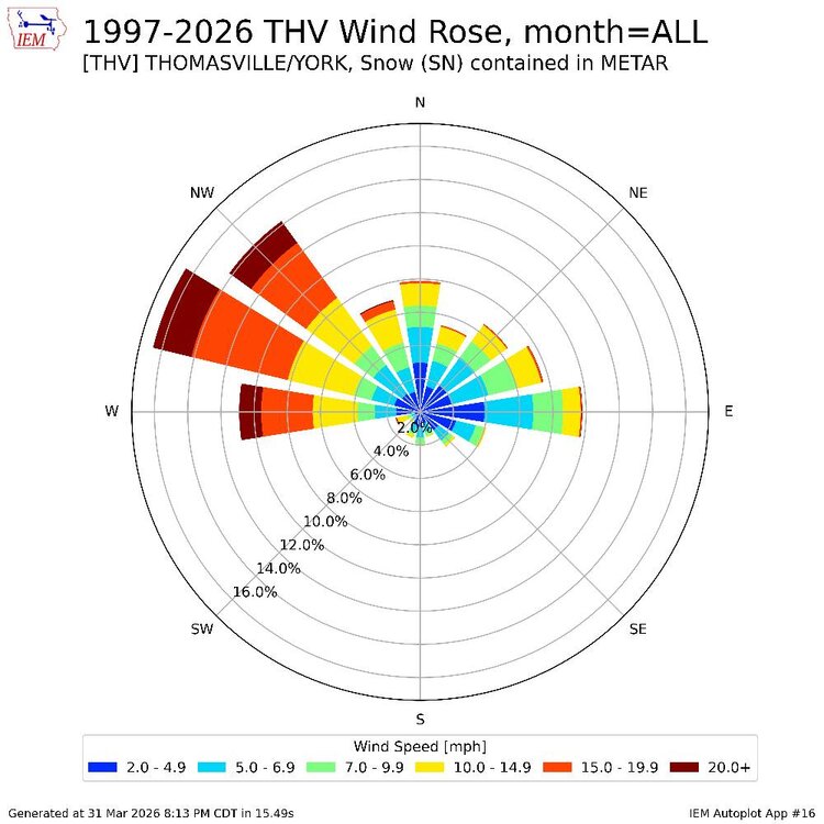
-
30 days to go That is not an April Fools joke, we're into the final month before May.
-
Central PA Spring 2026 Discussion/Obs Thread
Jns2183 replied to Voyager's topic in Upstate New York/Pennsylvania
You say that now, but just wait till we get locked in the 50's half of May. On the years ahead of us from work they finish a plus 1.7 and exactly normal for April and May. Although they did have April's with mean in 40s and may mean In 50's Sent from my SM-S731U using Tapatalk -
Central PA Spring 2026 Discussion/Obs Thread
Jns2183 replied to Voyager's topic in Upstate New York/Pennsylvania
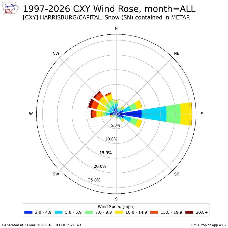
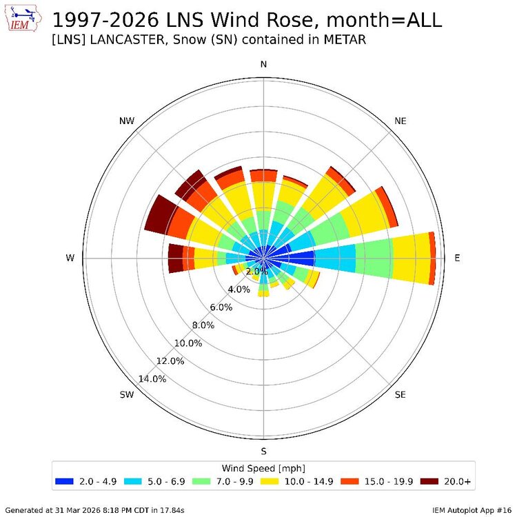
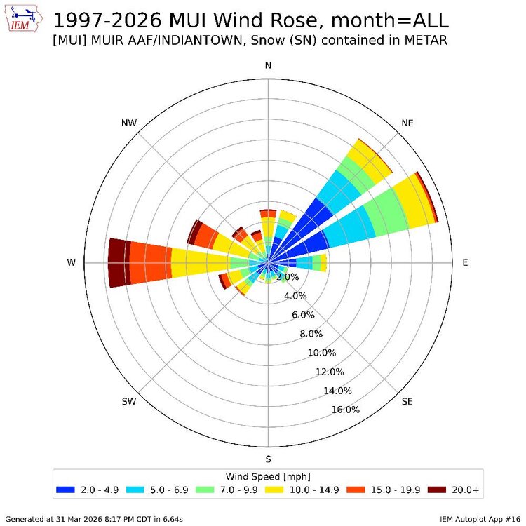
If you ever asked the question "I wonder what the local ASOS Stations at KCXY, KMDT, KTHV, KLNS record for wind when they have an kind of Snow" I have the fun answers below. Local terrain and microclimates making themselves known. Especially the wind tunnel that is the Susquehanna River Sent from my SM-S731U using Tapatalk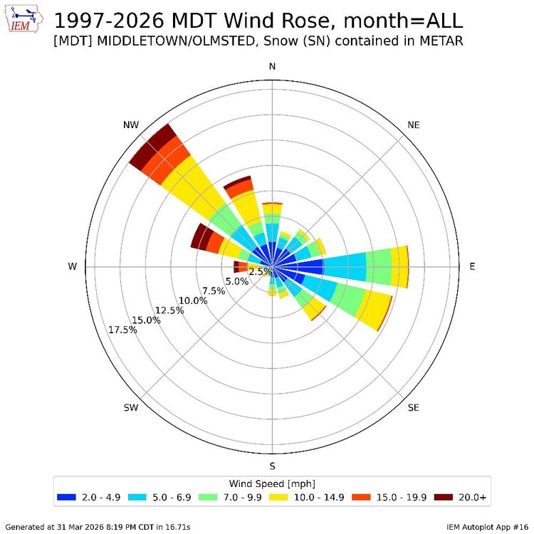
-

Central PA Spring 2026 Discussion/Obs Thread
Mount Joy Snowman replied to Voyager's topic in Upstate New York/Pennsylvania
63 when I left the house with no rain. We’ll see what today brings. The train is a callin’. -
Nice snowstorm coming uo for Minnesota. Enjoy.
-

Central PA Spring 2026 Discussion/Obs Thread
mahantango#1 replied to Voyager's topic in Upstate New York/Pennsylvania
-
70 degrees at 5am is gross!
-
Why does Jackass hate my posts ?
-
In case you haven't gotten it by now, winter is over: https://x.com/epawawx/status/2038305484810092870
-
Torch is back baby. Nice warm morning.
- Today
-
2015? We had a ice storm that winter,severe was literally non-existent which that year proceeded into a strong NINO later in 2015. Who knows,snowstorm in Jan 2016?That was the most snow we got here in decades.Seems like the potential flooding of Pac air this winter upcoming,AN temps should be the main course
-
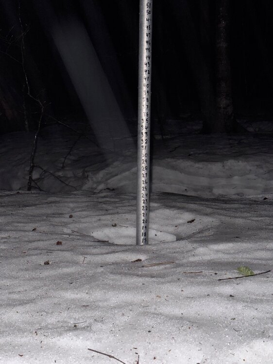
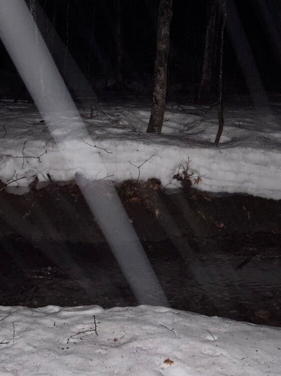
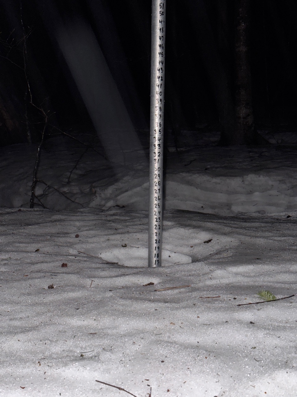
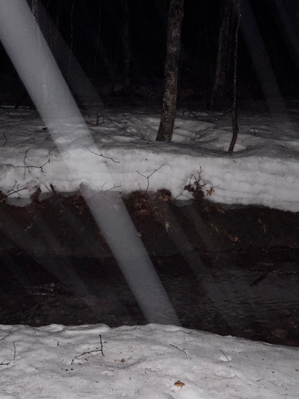
Miserable morning, rain and 41F. Snowpack at 1,500ft down to 18”.
-
.thumb.jpg.6a4895b2a43f87359e4e7d04a6fa0d14.jpg)
Central PA Spring 2026 Discussion/Obs Thread
Yardstickgozinya replied to Voyager's topic in Upstate New York/Pennsylvania
I occasionally read lazy forecast discussions, from time to time, but this one really stands out, especially in it's extended. Full discussion is in the link below. 211 FXUS61 KCTP 010817 AFDCTP Area Forecast Discussion National Weather Service State College PA 417 AM EDT Wed Apr 1 2026 .WHAT HAS CHANGED... * Severe thunderstorm watch #83 has been cancelled && .KEY MESSAGES... 1) Big temperature swings and periods of rain/thunderstorms continue through Easter weekend into the first full week of April && .DISCUSSION... KEY MESSAGE 1: Big temperature swings and periods of rain/thunderstorms continue through Easter weekend into the first full week of April At the surface, a quasi-stationary front will be located from southern Indiana east-northeastward into southern Pennsylvania by the afternoon. Surface dewpoints in the upper 50s and lower 60s F to the south of the front will contribute to weak instability. Increasing low-level convergence near the front and warming surface temperatures into the 70s should trigger scattered thunderstorms. 0-6 km shear in the 25 to 35 knot range and steep low-level lapse rates will support isolated strong to severe storms with potential for damaging wind gusts focused within west-east corridor to the south of I-80 to MD line. Periods of rain/showers continue tonight into Thursday morning. https://forecast.weather.gov/product.php?site=CTP&issuedby=CTP&product=AFD&format=CI&version=1&glossary=1&highlight=off -
Central PA Spring 2026 Discussion/Obs Thread
Yardstickgozinya replied to Voyager's topic in Upstate New York/Pennsylvania
I only included discussion specifically regarding localized threats. The full discussion is in the link below. No science to it, just a roll of the dice and some twisted intuition. I sense a convactive over achiever coming on today. Not that it will translate to today, but cpa had some decently, elevated parameters that went the waste yesterday . The cap fully eroded over most of the area by mid-afternoon, but a lack of forcing and meager mid-level's hindered any convective development. Although simple details, I think frontal timing and orientation are conducive to localize overachievement, especially if the sun can get that surface baked for us cpa southernish. SPC AC 010548 Day 1 Convective Outlook NWS Storm Prediction Center Norman OK 1248 AM CDT Wed Apr 01 2026 Valid 011200Z - 021200Z ...Ohio Valley/Mid-Atlantic... West-southwesterly mid-level flow will be in place over much of the eastern U.S. today. At the surface, a quasi-stationary front will be located in the Ohio Valley from southern Indiana east-northeastward into far southern Pennsylvania. Surface dewpoints in the upper 50s and lower 60s F to the south of the front will contribute to weak instability by early afternoon. Increasing low-level convergence near the front and warming surface temperatures will result in scattered thunderstorms during the afternoon. Several short line segments are expected to form and move eastward across the Ohio Valley into the central Appalachians. 0-6 km shear in the 25 to 35 knot range and steep low-level lapse rates will support isolated severe storms with potential for damaging wind gusts. A low-end tornado threat will also be possible. https://www.spc.noaa.gov/products/outlook/day1otlk.html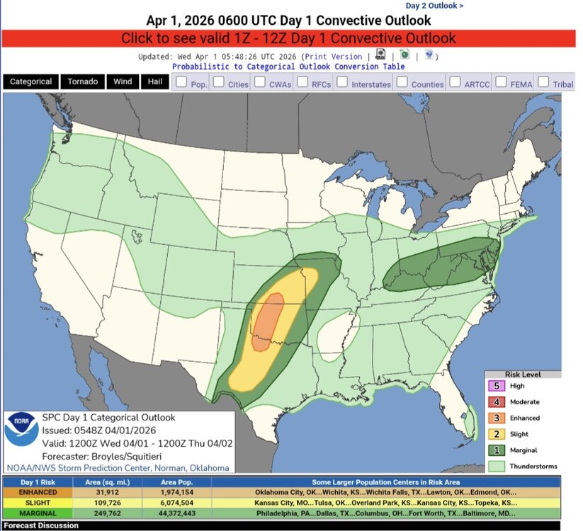
-
Here we go folks. I told everyone that winter isnt over yet.


- 22 replies
-
- 2
-

-

-
- april showers bring may..
- rain
- (and 2 more)
-
Here we go folks. I told everyone that winter isnt over yet.
-
 For April- DCA: +1.5 NYC: +1.3 BOS: +1.0 ORD: +2.0 ATL: +1.5 IAH: +1.7 DEN: +3.4 PHX: +2.9 SEA: +1.2
 -
Wow it is POURING SNOW at Mammoth right now! It's a RESET!!! https://www.mammothmountain.com/on-the-mountain/mammoth-webcam/woolly-cam
-

Mountain West Discussion
gallopinggertie replied to mayjawintastawm's topic in Central/Western States
It has been absurdly snowy this month in Juneau, Alaska (upwards of 6 feet of snow in March), in fact they have now set a new record for snowiest winter! https://www.ktoo.org/2026/03/23/juneau-breaks-march-snowfall-record-but-not-the-winter-record-yet/ -
71 out at 12:30am. Struggling to fall asleep as we are not wanting to turn the air on.
-
Exciting day for space enthusiasts tomorrow!Live updates: Will Artemis II launch tomorrow? Florida's weather outlook and mission status updatesLIVE UPDATES Last Update May 1, 2026 at 10:44 PM EDT NASA is targeting an April 1 launch for the historic Artemis II mission, with meteorologists currently tracking a favorable 80% "Go" weather forecast at Florida's Kennedy Space Center. Follow our live coverage for real-time radar analysis, countdown milestones, and the latest mission status as four astronauts prepare for humanity's first crewed journey to the Moon in over 50 years. https://www.foxweather.com/live-news/live-updates-will-artemis-ii-launch-tomorrow-florida-s-weather-outlook-and-mission-status-updates#google_vignette
-
Happy June-like start to April, Weather family.


.png.33ffb572674f8d2adcc96df2380f9b91.png)

