All Activity
- Past hour
-
I literally implied Irma in my last post because of the SW dip. What the bloody hell happened lad
-
I think for some every day this week is going to be in the 90s.
-
Yep I’m down in NJ it’s great water is upper 70’s as well
-
Big uptick in temps and dew points this am. Been in the 50's for a while, this morning's 66.7/66.0 felt terrible.
-
 Great week to be at the NJ shore warmers warm too
 -
Paradoxically, a weakening trend in the near term is probably the most omninous sign possible for the US, as it would cause the system to remain lower in latitude while being steered by the lower level flow. Obviously this increases the risk of the system missing the westerlies should it reorganize down the road.
-
This is a classic track, splitting the uprights between ACK and Bermuda. Lock it in
-
Yeah should be some dews up here albeit not oppressive. Classic hot summer day. Just like the ones I used to know.
-

E PA/NJ/DE Summer 2025 Obs/Discussion
JTA66 replied to Hurricane Agnes's topic in Philadelphia Region
Topped out at 89F yesterday and Sunday, so no official heatwave here yet. Had the AC off all weekend. Even now, I'm running it during the day and turning it off and opening the window before going to bed. Once the humidity kicks in, will be back to running it full time. -
Right lol. Good luck with that.
-
73/72....back to normal summer humidity. Ends a 10 day stretch of low DP at my station.
-
It's sort of the opposite too.... want a big pig ridge over Newfoundland and instead we've got a really anomalous ULL lol
-
Another deep summer day in the 90s. What a summer.
-
I don’t know it’s pretty humid here already.
-
That’s fine, but I guess enjoy wasting your time. Again go back to the pattern that gets canes up here. We do not have it.
-
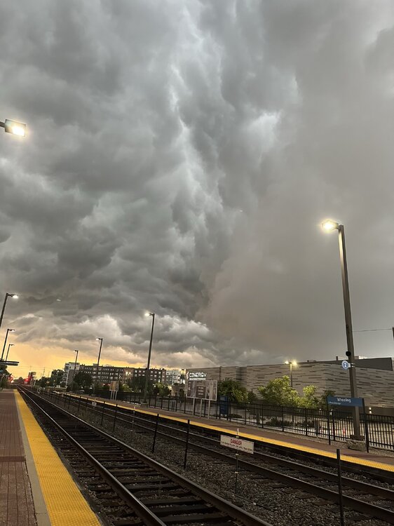
Couple of pics from the Wheeling train station this morning looking north.

- Today
-
-
Isolated at best.
-
Better than tracking endless days of sunshine, this is a weather forum after all lol
-
Havent had the AC on this entire month. Despite the warm days, all but 1 of the nights have dipped below 60, 2 of them below 50. Keep this going through October, but lets get some rain. Things are getting pretty crispy with the drier air.
-
 All the warm spots from Philly to Corona, Queens are pretty uniform around 30 days reaching 90°. 90° days for 2025 so far Philly…30 Highstown…32 TEB…31 EWR…33 Harrison….30 Corona…27
 -
Models should be interesting today. Out ahead of Erin you can clearly see the push from NE to SW coming off the Sarhan Dust Fields of Africa. This flow is trying to reassert itself as Erin moves generlly west. I would think that this fairly robust NE to SW motion of drier air will do two things keep Erin in check possibly even a period of weakening and force Erin more south or even southwest for a time as she heads generally westbound. I think this is what to watch now and until nearing the Leeward Islands over the next two days. The models may need to adjust to this possibility over time.
-
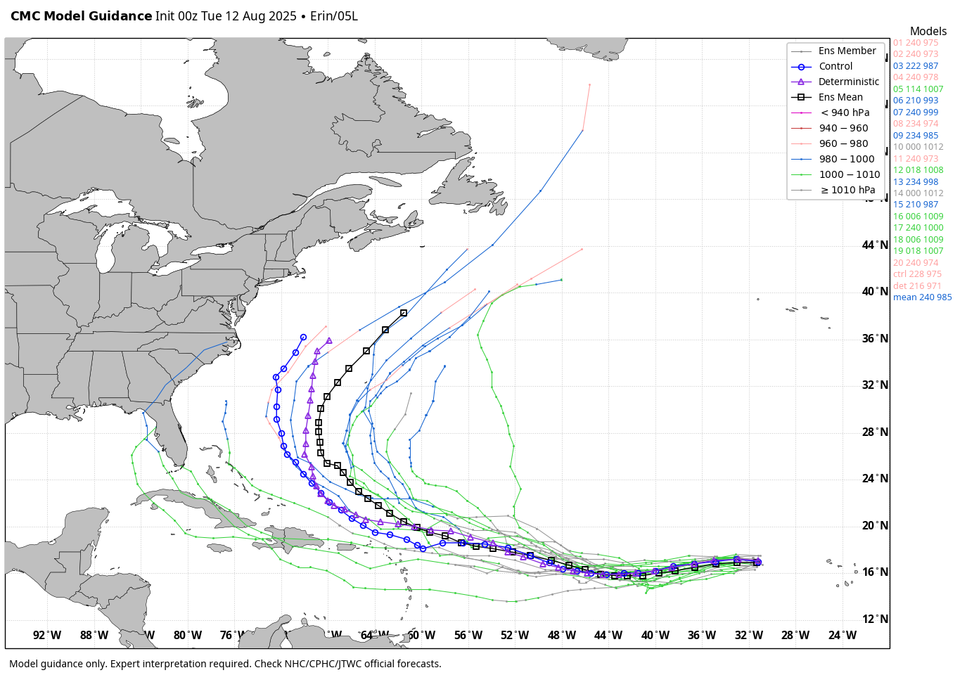
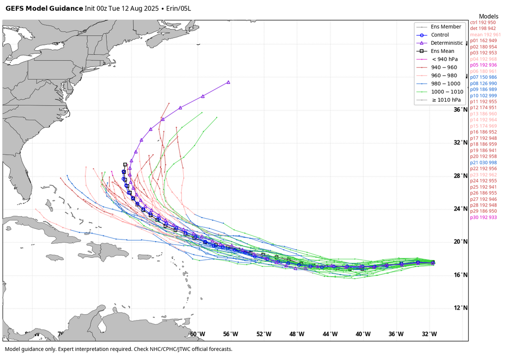
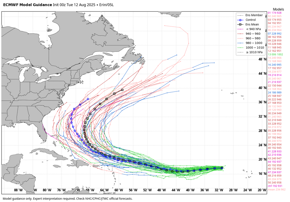
WB 0Z ensemble tracks.

-
 62, beautiful sunrise. Must've had a sprinkle of rain overnight as my windshield has dried up water drops on it.
 -
@jconsor lad posted this https://hurricanehacker.substack.com/p/tropical-storm-erin-forms-in-eastern

.thumb.png.4150b06c63a21f61052e47a612bf1818.png)