All Activity
- Past hour
-

Central PA Spring 2026 Discussion/Obs Thread
Itstrainingtime replied to Voyager's topic in Upstate New York/Pennsylvania
Just had the first TOR warning issued. Several thunderstorm warnings also out currently. -
Sun in Calvert finally. Still cool, 56F.
-
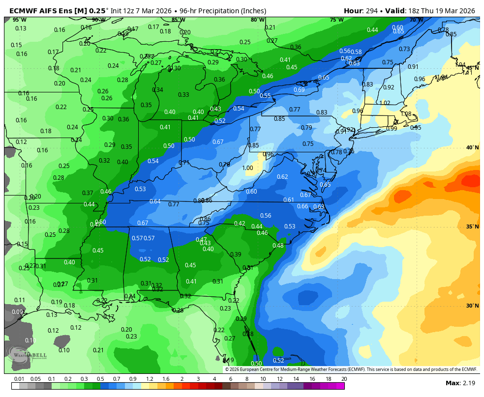
12z AI EPS for the period. The ingredients are there, we just need a specific chance or two to track in the window.

-
SUN in Columbia
-
It is however precarious ... any time you have polar air amassing into Ontario, with > sfc pressure than what is in our area/SE ... that's teetering with correcting that boundary S. But the model run itself was not "lost of Tuesday's warmth"
-
Just hard to buy with SW flow
-

2026 Severe Wx - General Thread
HillsdaleMIWeather replied to largetornado's topic in Lakes/Ohio Valley
165 now, might be upgraded to EF4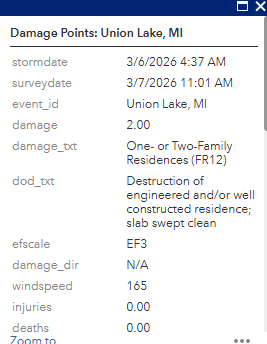
-
Glad we don't live there.
-
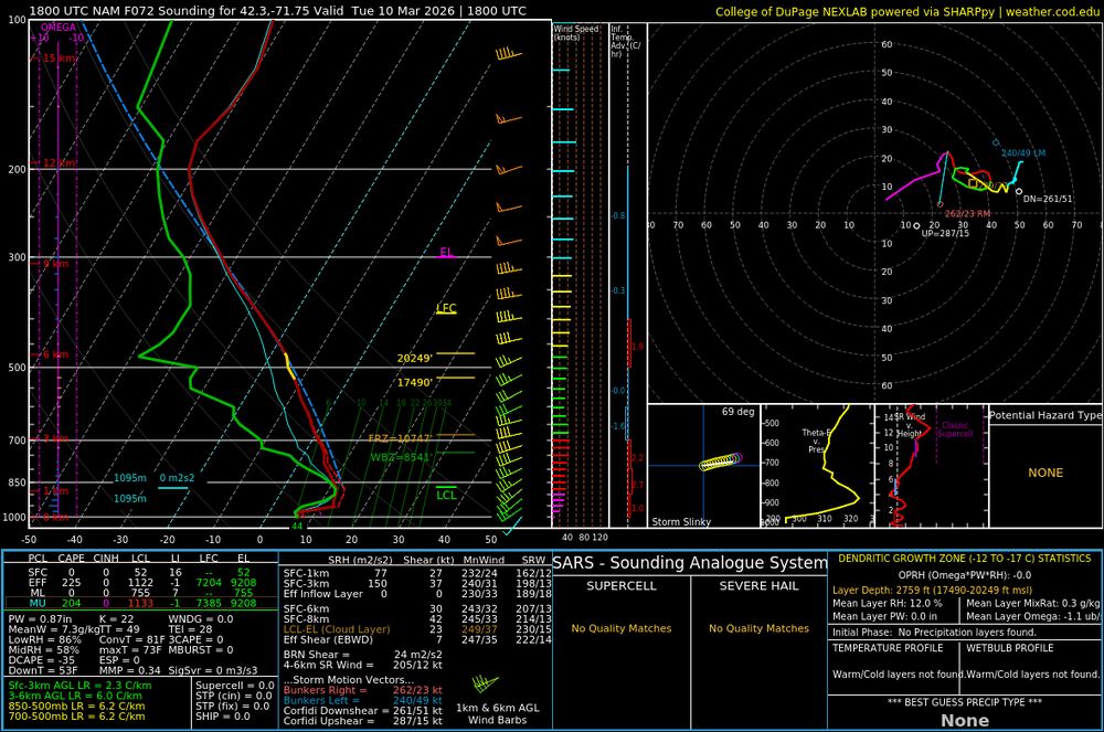
This is 21z Tues afternoon on the NAM I'm not seeing a raging argument here for a warm failure on that day ( relative to climo and previous ideas -)
-

Central PA Spring 2026 Discussion/Obs Thread
Voyager replied to Voyager's topic in Upstate New York/Pennsylvania
Still cloudy and foggy here with a temp of 44. -

E PA/NJ/DE Spring 2026 Obs/Discussion
Birds~69 replied to PhiEaglesfan712's topic in Philadelphia Region
That's why we shouldn't have created a Spring thread so damn early. It becomes confusing which thread to post in? Stuff out by Pitt... 48F/Overcast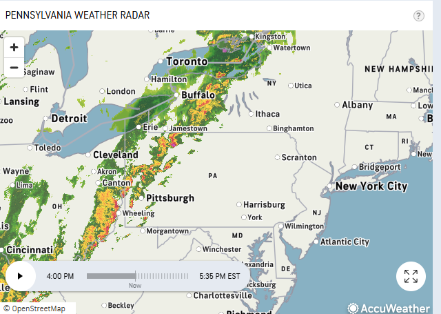
-
I set that to be 1951 -2020 just to be clear. I didn't say "below" anything. Not sure what you mean there. It was in regards to this tenor that this winter's somehow 'more like it's supposed to be'. Not sure that's wise. Too much data and actual math ( geophysical ) to suggest that is the case.
-
86 here for a high. Probably could have hit 90 if it was sunny all day. Amazing how hot that sun is already in March.
-
Don’t do it
-
-
18z NAM lost the Tuesday warmth
-
I’m pretty sure nobody is expecting to be multiple degrees below the 1951-1980 climate baseline going forward.
-
Wedge is breaking!
-
We still live a world that has been, and continues to consummately over-perform warmth (per verification). We just have been persistently given no excuse not to for perhaps 4 straight months. Today, with it's dense ceiling of solar blocked strata capping us drowned in left over polar inversion, definitely does not represent an excuse to go warm, either. If we bust the inversion, you will go above machine guidance and eat reality by force. Short sleeve shirt appeal over a snow pack occurs once this wiggly red feature wobbles through our region by tomorrow We haven't had a day of 64 F in so long. I sense that some posters doubt it can? some kind of acclimation bias. It's funny how willing folks are to think of this as back to normal winter and referencing climate like this is 1992. Reality check: this was the anomaly. Not the other way around. That's not coming back and you are wrong to perceive matters that way. Don't be fooled by this blue blob of fortunate.
-
This is the dumbest weather. I hate all of this.
-
Ended up with an overperforming 8" which still has me under 20" for the year. And there's nothing in model fantasyland to even think of getting excited about.
-
Pea size hail with a thunderstorm in Boone
-
Ok chief
-
Chestnut Hill, MA about 9 miles WSW of BOS. Hard to grade with possibly more coming. However, with about 65” of snow to date and prolonged snow cover in addition to below normal temperatures I’m giving it a B+. Should we get another significant event the grade goes up.
-

Central PA Spring 2026 Discussion/Obs Thread
MAG5035 replied to Voyager's topic in Upstate New York/Pennsylvania
Busted back out of the overcast/drizzle this afternoon and well into the 60s again today (as high ans 65ºF) after it had moved back in after dark last night. The severe setup definitely escalated quickly in western PA, with temps reaching near 80 with dewpoints near 60. Decent shear/wind parameters and at least some CAPE (500-1000) along with some discrete cell formation. That will definitely need monitored over there. Obviously will remain much more stable in eastern PA at the low levels with the overcast and cool air damming but might still be some rumbles of thunder with anything that makes it over that way tonight. I do expect non-diurnal warming this evening in the spots that have been most locked in to the CAD as the approaching system/ SW flow will eventually mix some of the warmth down.