All Activity
- Past hour
-

January 2026 regional war/obs/disco thread
Diggiebot replied to Baroclinic Zone's topic in New England
Can you post it plz and thanks -
Crazy that we can’t get snow with temps in the low 20’s. Why doesn’t anywhere else have this issue?
-
That's actually a really good observation. Physics models shifted south from 0z to 18z before shifting back north. AI models starting shifting south 12z to possibly 6z?
-
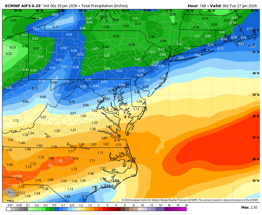
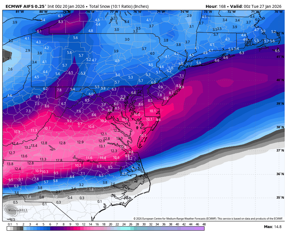
I don’t think people realize how ridiculous this AIFS output is in the grand scheme of things. This is a crazy output that would certainly lend credence to a potential for 1 inch or more of QPF for a large portion of this sub forum. Even if you don’t get 1 inch of precip from this set up you can still walk away with 8+ inches of snow. Incredible set up. We have brewing right here. Good times
-

January 25/26 Jimbo Back Surgery Storm
Thrasher Fan replied to Jimbo!'s topic in Southeastern States
Euro AI further south -
We’re starting to converge on a solution for part one. That was up until 0z a point of contention with the SW coming east. Now that’s more or less settled (hopefully) and we get to see what type of storm rolls east. We still got a couple days to go before we get to the solution with that one
-
This is for all the great setups in the past that have been ruined by a stupid stubborn baja cutoff that refuses to eject into the flow.

-
Even if it is some sleet and zr, I am speaking for the fact that the severity of the situation is increasing the totals of something frozen when compared to the previous run. I am not just focusing on snow, I think it's important to see that moisture output is increasing while temps remain steady in the low 20s or teens and that this is becoming more likely a potentially dangerous storm. As modeled something we haven't seen in many years.
-
Might just a little early to call that, imo. It is just early Tuesday!
-
Something to watch. Do the AI models lag in the trends of the physical models. Just seems like they are 12 hours behind with what the other models are doing.
-
Probably not. Ain’t going to know for sure for another 2-3 days honestly.
-
Euro AIFS south of 12z but north of 18z
-

Possible Record Breaking Cold + Snow 1/25 - 1/26
MJO812 replied to TriPol's topic in New York City Metro
Euro AI is slightly south but still nice -
Euro AI slight tick south, seems like we're starting to converge on a solution
-
WB EURO AI continues to tick south.
-

MO/KS/AR/OK 2025-2026 Winter Discussion
StormChazer replied to stormdragonwx's topic in Central/Western States
GFS bows to King Euro again. Although it's not the totals we want to see for us, it's more important that the trend was to fall more in line with the Canadian and Euro and it's no longer out to sea. Now lets hope this massages northward. Here is the 0Z Canadian as well. -
Larry cosgrove just peed his pants
-

January 25/26 Jimbo Back Surgery Storm
NorthHillsWx replied to Jimbo!'s topic in Southeastern States
This is the rare setup where someone could get 6+” of sleet. Models showing surface maps in the low 20’s with 850s torching and 925 around freezing over a large area. Once again a lot will change but someone could get a legendary sleet bomb based off what I’ve seen. Chance for a new ice age next week with southern glaciers if this pans out -
January 25/26 Jimbo Back Surgery Storm
Thrasher Fan replied to Jimbo!'s topic in Southeastern States
time for the king
-
Apologies if this has been posted elsewhere, but good lord. https://x.com/Electroversenet/status/2013280295341179216?s=20
-
Was a great run honestly. .
-
The good news, and we've seen it before ... Snow on th ground, fresh snowpack, will definitely help with radiational cooling and enhance the risk for sub-zero min temps assuming we can decouple. BUT, it can also provide a nice layer of insulation to prevent the intense cold from seeping in the subflooring. Let's hope so anyway!
-
With the Baja ejecting...we end up with a double moisture feed from the Gulf and the Pacific..if there is cyclogenisis (Ukie/GEM) the 850 winds (howling from south on those 2) are going to shove the 850 frontal right over top the low level arctic cold. A wave is only going to shove it right close to the southern border, 850 winds way weaker.
-
I think you’re right on this one. We’re past where Feb 20th failed
-
Euro out to 4 hours. Very little ticks do far


