All Activity
- Past hour
-

November 2025 general discussions and probable topic derailings ...
JACKASS replied to Typhoon Tip's topic in New England
Can't disagree with ya there. -
remains of a once-bright burning bush
-
Tomorrow will turn briefly milder with highs generally reaching the lower and middle 50s before another cool air mass moves into the region. Some showers are possible with the frontal passage, but rainfall totals will generally be under 0.25" in most parts of the region. In the wake of the cold front's passage, a period of below normal temperatures will prevail through at least Wednesday and possibly Thursday. Highs will be mainly in themiddle and upper 40s in New York City with lows in the middle and upper 30s. A milder pattern could develop the latter part of next week. Some rain is possible. Meanwhile, today will be Central Park's 1,386th consecutive day without daily snowfall of 4" or more. The record of 1,394 days was set during February 22, 1929 through December 16, 1932. That stretch ended with 6.7" daily snowfall on December 17, 1932. The ENSO Region 1+2 anomaly was -0.2°C and the Region 3.4 anomaly was -0.7°C for the week centered around November 5. For the past six weeks, the ENSO Region 1+2 anomaly has averaged -0.07°C and the ENSO Region 3.4 anomaly has averaged -0.55°C. La Niña conditions will likely continue through at least mid-winter. The SOI was +6.42 today. The preliminary Arctic Oscillation (AO) was -1.018 today. Based on sensitivity analysis applied to the latest guidance, there is an implied 57% probability that New York City will have a cooler than normal November (1991-2020 normal). November will likely finish with a mean temperature near 47.4° (0.6° below normal). Supplemental Information: The projected mean would be 0.3° below the 1981-2010 normal monthly value.
-
Hard to believe at this time last week we were talking about feet of snow falling in areas that are now over 70 degrees. Got to love November in the Midwest.
-

2025-2026 ENSO
donsutherland1 replied to 40/70 Benchmark's topic in Weather Forecasting and Discussion
Griteater is very knowledgeable. It will be fasinating to see how things evolve. -
Yes Santa Now bring me a snowy winter for Christmas.
-
Weeklies still look good for December . We just have to be patient.
-
https://x.com/p_simmswx/status/1989685215497752663?s=46&t=m4Eqkekadb-JCXTm7k-Txg
-
-
We take this and run with it.
-
Its common in the TNH pattern...93-94, 14-15 winters saw the -AO/+NAO often.
-

Central PA Fall Discussions and Obs
Itstrainingtime replied to ChescoWx's topic in Upstate New York/Pennsylvania
Not the best start... -
Might be an ice storm pattern for my part of the world with cold air under cutting mild SW flow aloft
-
Torching at 70
- Today
-
Feels like it wants to be warm, though. The lack of wind feels amazing.
-

November 2025 general discussions and probable topic derailings ...
powderfreak replied to Typhoon Tip's topic in New England
Ha I noticed it was pretty snowy in Maine too. CAD wedge and secondary trying to get going. -

November 2025 general discussions and probable topic derailings ...
dendrite replied to Typhoon Tip's topic in New England
Wtf is that weenie 2” over me. I’m not finished with the yard work yet. -
Phase 6-8 in DEC are not bad at all. 6 turns bad in JAN/FEB. A lot of misconceptions about MJO phases. Use Roundy's RMM: https://www.atmos.albany.edu/facstaff/roundy/waves/rmmcyc/index200reg.html
-
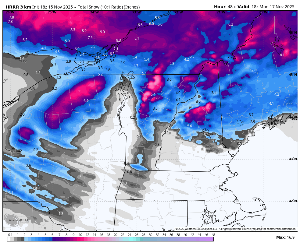
November 2025 general discussions and probable topic derailings ...
powderfreak replied to Typhoon Tip's topic in New England
Lining up to get the northern Greens another high end snow event tomorrow into Monday night. This is only through Monday 1pm and still going strong. Another 1-2” QPF snow event for the mtns.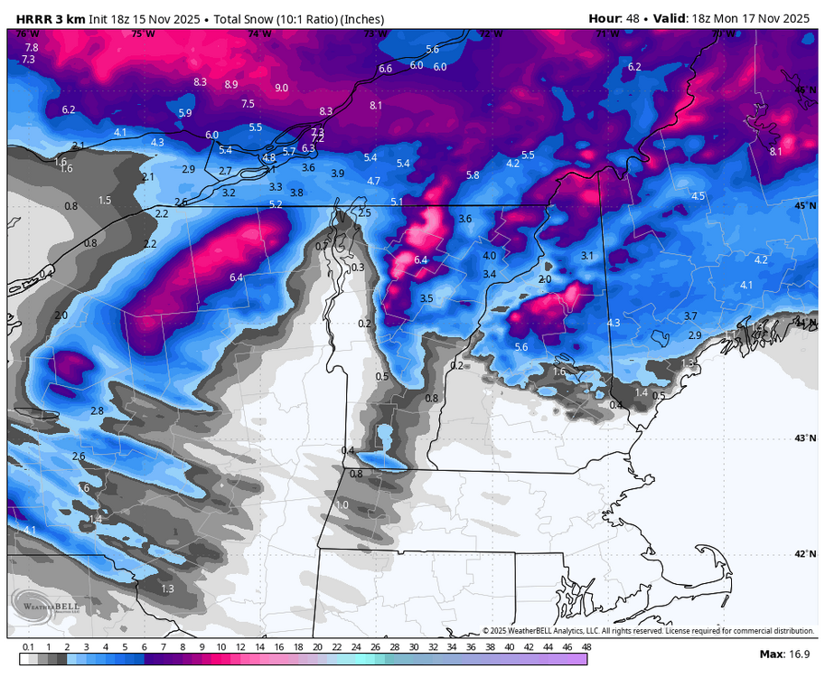
-
It wouldn't surprise me if there's a snowstorm Friday since I'm flying out of town Thursday. Happens all the time.
-
Deterministic runs are starting to pick up on a decently cold shot right after Thanksgiving. Still plenty of uncertainty, but cold enough for snow if we time it right.
-
The CFS seasonal today was wall-to-wall cold for DJF.
-

November 2025 general discussions and probable topic derailings ...
tunafish replied to Typhoon Tip's topic in New England
Was between 32-34 around the same time, then the wind quit and down it went. Only day this month it's been unobstructed sun the entire day.
-
Not a thing this cold season. Build an arc.
-

November 2025 general discussions and probable topic derailings ...
weathafella replied to Typhoon Tip's topic in New England
So is April.