All Activity
- Past hour
-
All of our classic winters go like this lol
-
lol so what? AI is the shit. Its everywhere for everything.
-

-
AI
-
Be nice to have some blocking to help right now
-

January 2026 regional war/obs/disco thread
SouthCoastMA replied to Baroclinic Zone's topic in New England
This could be huge, all
-
The Euro had the same general idea, just didn't quite get it done with the phasing
-
-
34 / 20 as we progress warm the next 3 days as ridge builds west trough generally into the east by Thu/Fri and looking overall below normal from then on with some strong cold into the northern Plains/MW and east potentially by the 23rd. Looking overall drier on the guidance but trough could yield a period or two of some light/mod snow. 1/12 - 1/15: Above normal 1/16 - 1/21 : Below normal / dry as of now 1/23 - Beyond: Looks overall cold and potentially some stronger cold (nearby could reach the area)
-
lol storm cancel
-
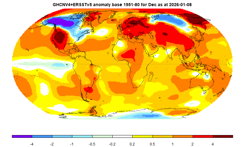
I figure you're kidding around but ..still, it doesn't incite much mystery ( it's useful to point this out to the pedestrian -) The flow is just biased in favor of some regions and not in others. That's typical 3 million years ago, today.. and tomorrow. But, we are a whopper exception to the rule according to some sourcing. Here's December according to the ERS tracking. I'm curious about Novie but ... just arm chair recall, I suspect it'd be 75% likeness or more. The early season blocking/front loading aspect serviced these cold regions and it really quite obviously got going two months ago. Bringing that back to the dry continental aspect, one of other NW flow pattern results - below being the temperatures.
-
The 6z Euro has a clean, amped ridge out west and clippers digging for gold. I have not seen this pattern since Jan/Feb 2015.
-
The old philosophical conundrum: If a thread is started in the middle of the night and nobody is aware of it, did it exist??
-
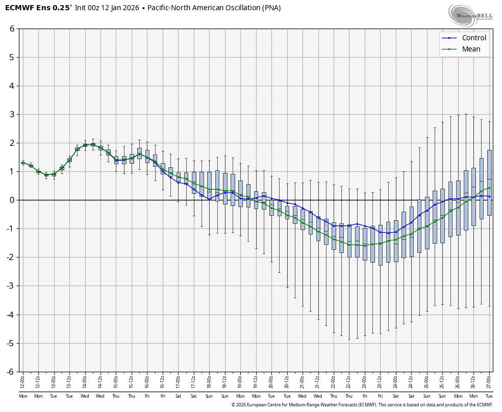
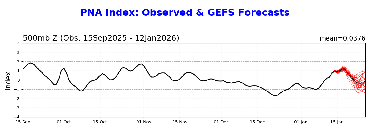
Down here in the SE like at RDU/ATL, there’s also a notably higher correlation to a +PNA than to a -NAO for 3-6”+ snowstorms. The PNA seems to be the most telling single index. Speaking of which, the 0Z EPS mean actually has it coming back up to + at the end (1/26). If this occurs, that will increase the chance that Jan will end up with a net +PNA like all of the other -ENSO -PNA Dec transitioned to: However, on the GEFS, it still doesn’t get back up to +PNA as of 1/26 though it appears to be on its way just afterward:


-
Wish it could be 6 months of 80s 4 months of deep winter and 1 month fall and spring.
-
especially since its still 3 days away
-

January 2026 regional war/obs/disco thread
ORH_wxman replied to Baroclinic Zone's topic in New England
It's kind of wild that just taking a random loop of the 06z GFS, we have like 3-4 distinct shortwaves over the next 10 days that dive into the eastern US and none of them can produce any meaningful QPF. Hopefully that changes, but this is quickly turning into a very dry winter if we can't get these things to produce anything. -
I mean, it’s a little believable.
-
Not saying we wont see snow before this- I think we will- but this period offers a favorable h5 look for our region to get snow.
-
"Based on sensitivity analysis applied to the latest guidance, there is an implied near 55% probability that New York City will have a cooler than normal January (1991-2020 normal). January will likely finish with a mean temperature near 33.5° (-0.2° below normal). " That quote is from Don's post from yesterday - How you consider 0.2 below normal "warm" is beyond me.
-
We’re due for a March triple phaser.
-
It won't be normal. Depends on your definition of just below normal. Average CPK high temps in January are approx. 39.5 degrees.
-

January 2026 regional war/obs/disco thread
40/70 Benchmark replied to Baroclinic Zone's topic in New England
Oh yes...February will definitely be RNA and probably March, too. -
Yes, we know the cycle by now
-
Who would have thought...cold and dry is this CC dominated era.