All Activity
- Past hour
-
Getting the southern fringes of the storm. Not much wind and a little rain so far. Worst of it looks like it is moving over me now. Downpour now....
-
Nothing severe here, but the creeks will definitely be higher tomorrow morning. Healthy nighttime storm.
-
https://4000.weatherstar.dev/
-
Just took the trash out and wow the lightning. Looks like a crazy storm blowing in.
-
Any urban area will for sure. It will suck but we have been super lucky so hold out this long ….
-
With mid 70s dewpoints midtown HBG might struggle to get below 80 at least one night.
-
Eerily calm here with only a light breeze and thunder now rumbling over the Catoctins.
-
Yep, starting to see lightning in the distance.
-
Well I understand Tip doesn’t care for the verbiage but we are overdue for something. Hopefully this summer
-
looks like install day is almost here !
-

-
This one looks legit on lightning radar, too. It’s on a beeline for mby.
-
I filed for the money. Mine didn’t seem to be cooling right anyway so I figured might as well get paid. I threw the old unit in for now. Haven’t really needed it.
-
Weekend looks warm but Sunday is the interesting day. Is it mid 80's or mid 90's in the hot spots? Sunday has gotten progressively warmer with modeling. Looks like precipitation chances are minimal, so maybe this is the weekend that breaks the streak!
-
We had a lot of damage here, particular the Idlewell neighborhood down the hill from me. There was an event in 2010 I believe where I had nickels and I think @amarshall had ping pong balls at Wollaston in Quincy. Was at like 2am.
-

2025 Lawns & Gardens Thread. Making Lawns Great Again
Childude645 replied to Damage In Tolland's topic in New England
were shaping up for a DRY july on the vineyard, i manage robotic lawn mowers on over 100 lawns here on the vineyard, and by my observations its getting dry. -
2025 Lawns & Gardens Thread. Making Lawns Great Again
Childude645 replied to Damage In Tolland's topic in New England
despite rainy weekends and a few significant rain storms. if i can find a way to post a recent cliff slide i recorded from a few weeks back i will. -
You just reminded me of that. I guess it was in fact a derecho. For me it was a wild 4 minutes and that was it. I hope to do better than that soon!
-
Excessive heat warnings look likely in the LSV. And the nights won’t cool below 70 next week so we’re gonna bake fast
-
Yep. Those trees block the snow too. So they say.
-
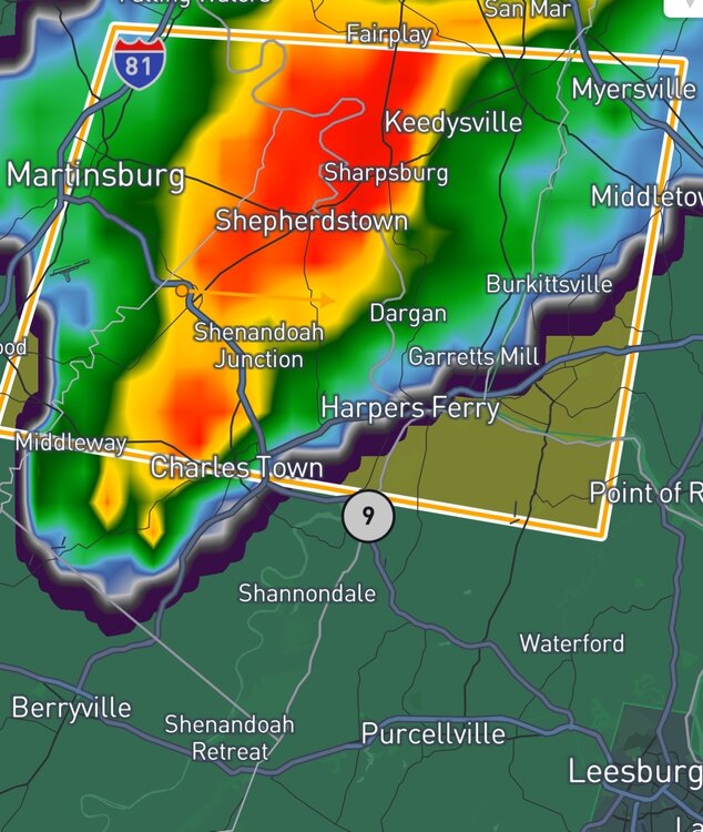
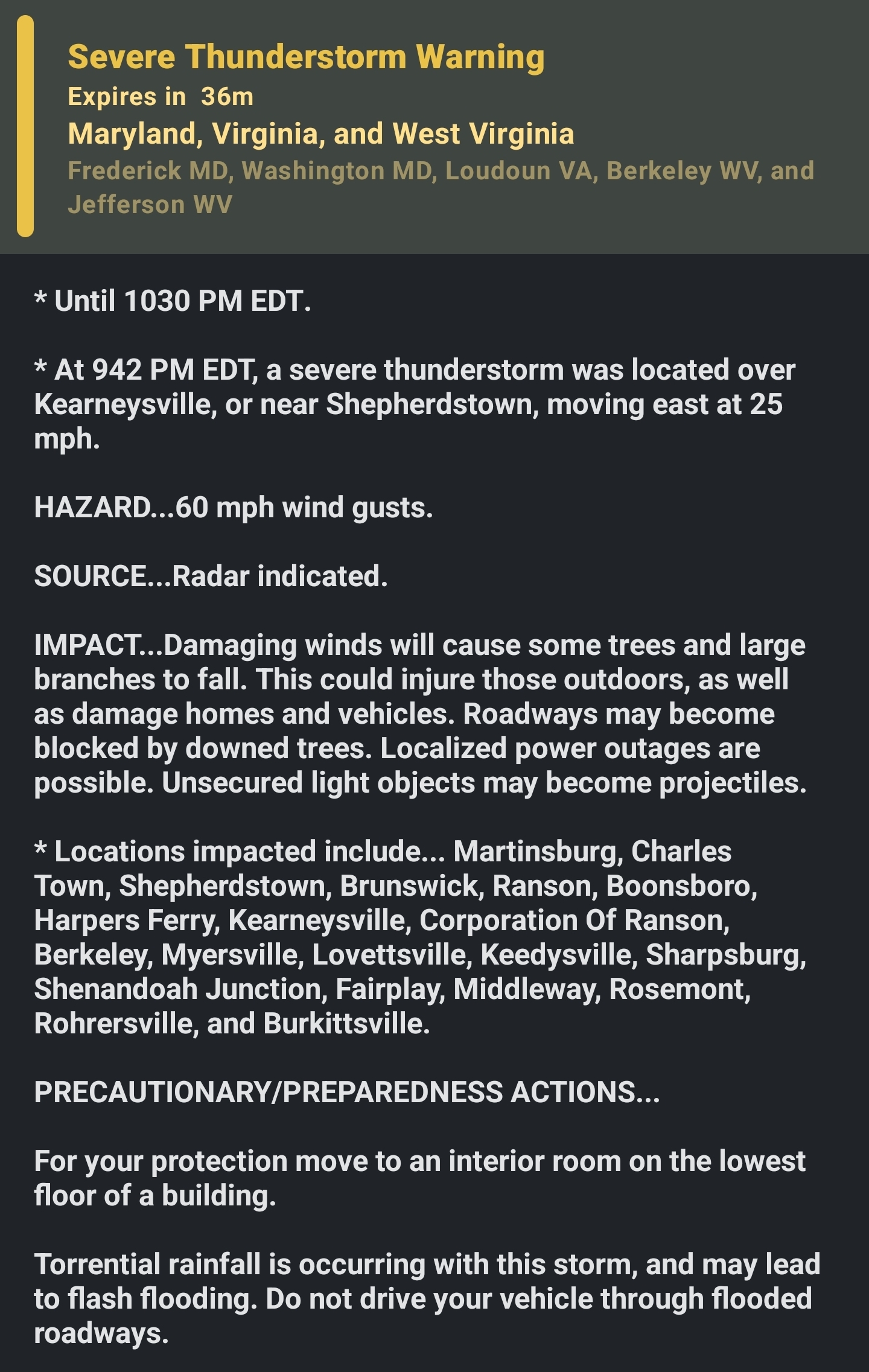
a * Severe Thunderstorm Warning for... Southeastern Washington County in north central Maryland... West central Frederick County in north central Maryland... North central Loudoun County in northern Virginia... Central Jefferson County in the Panhandle of West Virginia... Eastern Berkeley County in the Panhandle of West Virginia... * Until 1030 PM EDT. * At 942 PM EDT, a severe thunderstorm was located over Kearneysville, or near Shepherdstown, moving east at 25 mph. HAZARD...60 mph wind gusts. SOURCE...Radar indicated. IMPACT...Damaging winds will cause some trees and large branches to fall. This could injure those outdoors, as well as damage homes and vehicles. Roadways may become blocked by downed trees. Localized power outages are possible. Unsecured light objects may become projectiles. * Locations impacted include... Martinsburg, Charles Town, Shepherdstown, Brunswick, Ranson, Boonsboro, Harpers Ferry, Kearneysville, Corporation Of Ranson, Berkeley, Myersville, Lovettsville, Keedysville, Sharpsburg, Shenandoah Junction, Fairplay, Middleway, Rosemont, Rohrersville, and Burkittsville.
-
the approaching storm was just warned for radar indicated 60 mph winds.
-
An area of pop up thunderstorms, some heavy, is moving in to this area from the SW this evening.
-
Solidly into our stormless summer pattern now. Didn't get a drop since Saturday night.
-
Especially because the correct term is Woodchucks! What stupid white-plated Flatlanders!


.thumb.png.4150b06c63a21f61052e47a612bf1818.png)


