All Activity
- Past hour
-
Hope I'm wrong - but this is not looking promising at the moment...
-

Septorcher 2026 Discussion - Endless Summer
JACKASS replied to Damage In Tolland's topic in New England
Over an inch of rain tomorrow? Don’t need that all in one shot! Hope the ones needing it get what’s needed in your areas!! -
 vipps approved canadian online pharmacy: canadian pharmacy drugs online - canadian mail order pharmacy
 -

2026-2027 Fall/Winter Mountain Thread
Maggie Valley Steve replied to BlueRidgeFolklore's topic in Southeastern States
I had a couple of rounds of showers today which kept temperatures in the low 70's. The upcoming week is likely our last here in the mountains with highs in the low 80's. -
Any short range models showing anything interesting?
-
Wonder if there could be a flood threat about to unfold on the eastern foothills of the Shenandoahs down Charlottesville and south. Bunch of slow moving storms in an extremely moist airmass drifting towards an area that will provide orthographic lift.
-
Would be a better fit if the dog was Frosty!
-
canadian mail order pharmacy and canadian drugstore online trusted canadian pharmacy https://www.google.kg/url?q=https://northrxcanada.shop canadian mail order pharmacyor https://www.donchillin.com/space-uid-524965.html canadian pharmacy drugs online [url=https://images.google.com.gt/url?q=https://northrxcanada.shop]legitimate canadian pharmacy[/url] canadian pharmacy checkerand [url=https://shockingbritain.com/user/bqceoibjpc/]canada pharmacy online[/url] real canadian pharmacy
-
No season prior has had two very close passes to any of the islands w/ both at hurricane-strength. All areas "pay the piper" sooner or later when it comes to hurricanes. HI now, FL 2004 and other years, New England 1938-1960, the GA coast in the 1890s (3 hurr landfalls, 2 in one season!), etc. Why is Hawaii generally not favorable for TCs most of time? Gt this write-up some years ago. Very strong El Nino disrupts the typical flow/circulation regime, and makes it more favorable. ----- A TC approaching the Hawaiian Islands will often get sheared due to strong upper southwesterlies putting too much stress on the vertical structure of a TC moving westward in the slower but more dense trade flow over only marginally warm water. The shape and size of the NPAC basin means that, particularly in summer w/ the shorter wavelengths of the upper westerlies, there is usually room for more than one ridge or one trough in the middle and higher latitude flow. The Gulf of AK therefore often becomes home to a strong vertical high pressure cell, while troughing may prevail farther to the W near the coast of Asia and Japan. The rounded shape of the Gulf of AK fits well w/ the shape of the high w/ the high usually centered close to 45N latitude. A strong high at that latitude over the oceans can be considered a type of blocking high of great vertical extent. A strong blocking high tends to induce a cutoff low centered 15 deg S of the high center, which would place the low at 30N. This low pressure circulation in the weaker flow of summer is often not easy to detect in the surface flow except for a slight cyclonic shear w/ the easterlies increasing going northward and a slight curvature in the isobars along w/ increased clouds and showers. The longitude of these pressure features w/ the high at 45N and the low at 30N is usually near 160W. Thus, by extension, over the Hawaiian Islands still farther to the S and SE at 20N between 155W and 160W, this area experiences during this very common flow pattern of summer and fall a broad band of southwesterlies aloft, which is detrimental to TCs.
- Today
-
I may have to put in my reservations ahead of schedule
-

Septorcher 2026 Discussion - Endless Summer
SouthCoastMA replied to Damage In Tolland's topic in New England
We cautiosly accept the heavy rain, knowing that stein is always lurking in the trees like Predator, or in the closest sewer like pennywise -
Septorcher 2026 Discussion - Endless Summer
SouthCoastMA replied to Damage In Tolland's topic in New England
-
That is an ugly, ugly year here and up at WXW2 it’s catastrophically bad. SE must’ve hit on a scraper that melted down the forum.
-
Septorcher 2026 Discussion - Endless Summer
SouthCoastMA replied to Damage In Tolland's topic in New England
It's coming..1-2" -
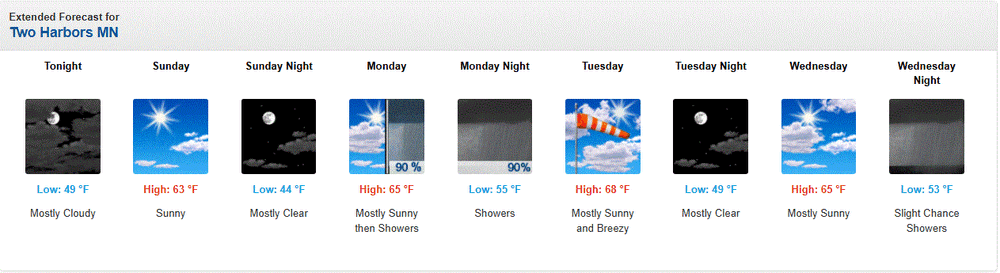
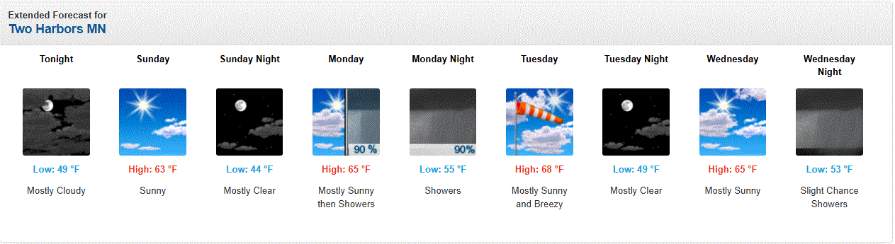
Fall is arriving.
-
Temps in the low 70's on a breezy W wind this aftrn. Turned NW with a cloud deck moving in, and temps are dropping steadily this evening.
- Yesterday
-
More rain coming up from the south and possibly from the west-southwest as a Nino Late Summer/Autumn continues to unfold over the DMV
-
Another miss today...trace of rain
-
1.07" so far. I must say the rain this summer has been well timed and well spaced out (at least imby). Good soaker this afternoon/evening after a truly tropical airmass earlier.
-
Delicious basketball weather. Also, our ability to get to 70+ dewpoints the last several months continues to be impressive.
-

2026 Atlantic Hurricane Season
vortex95 replied to Stormchaserchuck1's topic in Tropical Headquarters
Some EPS members are bullish on the medicane (see attachment). Why they refuse to call these for that they are is perplexing, They have been documented since the 1940s, and some clearly have become fully tropical in nature. Like this one from 2020 (strongest medicane on record I think). https://en.wikipedia.org/wiki/Cyclone_Ianos Contrary to what this post says (link below), medicanes are not extremely rare, not are they rare, not when you go back and look history of them. There have been 92 systems documented since the 1940s, and counts prior to 1990s are likely too low. https://x.com/MatthewCappucci/status/2098869390833807409 /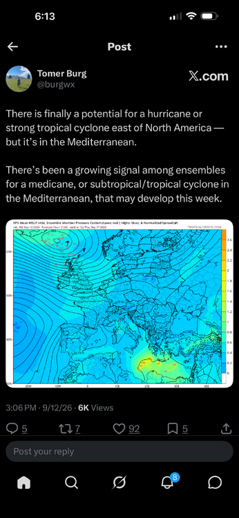
-

Central PA Summer 2026 Discussion/Obs Thread
canderson replied to Voyager's topic in Upstate New York/Pennsylvania
Doubt we get storms but we should hopefully get nice rain! Maybe a thunder or two. -
@BlizzardWx's site.
-

Septorcher 2026 Discussion - Endless Summer
Sey-Mour Snow replied to Damage In Tolland's topic in New England
I’d prefer a sunny day if it’s going to rain might as well be epic -
2026 Atlantic Hurricane Season
vortex95 replied to Stormchaserchuck1's topic in Tropical Headquarters
Excellent point and observation. It shows 2024, for instance, when it was so suppressed during the peak, wasn't just fluke. It now has happened 2 more times, all in a row? That is non-trivial, and definitely warrants a lot of study. And all 3 seasons w/ the peak squashed, it all has been for different reasons. Are the more reasons why this could happen? Not necessarily happens again next year, but what is the true range of possibilities here? I would argue there are more. This all goes into understanding TCs and environments more, and eventually leads to better forecasts!











.thumb.JPG.418e8a9a2902ae687ec35ff4bc0e038e.JPG)