All Activity
- Past hour
-
Let’s do 6z gfs
-

Is we back? February discussion thread
40/70 Benchmark replied to mahk_webstah's topic in New England
I recall one event where we have like 5" at my dad's in Woburn....I was ecstatic, until I heard the cape had over a 1', then my mood dampened rapidly. Even at like 7 years old, I was IMBY to the core. -
Is we back? February discussion thread
40/70 Benchmark replied to mahk_webstah's topic in New England
He's at the "bargaining" stage of acceptance, I see. -
Yeah I remember NNE doing well in the limited times I went up there. And then I remember hearing about the random biggies the Cape got and down toward the mid Atlantic.
-
 If the Niña is on the way out and the floodgates finally open this time the drought will be gone by May.
 -
Is we back? February discussion thread
40/70 Benchmark replied to mahk_webstah's topic in New England
It was the decade of "-EPOoooooo no", as @CoastalWxsays. The 80's was a decade heavily predisposed to +NAO/-EPO...which made for a high volume of messy snow to rain events in SNE, but NNE cleans up in that regime. I remember we would have 3" of crust on the ground where I grew up in Wilmington/Woburn area, only to get up to our camp in Heniker, NH and just be awe-struck when they had like a 3' pack. -
This has been our coolest November to mid-February in over a decade. But since the Northern stream and Western ridge was so dominant, we couldn’t achieve the snowfall totals of 1996, 2014, 1994, 2003, and 2011. Some lingering influence from the longer term lower snowfall pattern since 2018-2019 even though this winter was much colder. But I am very happy we got our big benchmark snowstorm which brought many close to the long term 25 to 30 average with the more active STJ for a week in late January. Time Series Summary for NEWARK LIBERTY INTL AP, NJ Coolest 11-1 to 2-12 periods since 1991 Click column heading to sort ascending, click again to sort descending. 1 1996-02-12 33.7 0 2 2014-02-12 35.1 0 3 1994-02-12 35.3 0 4 2026-02-12 35.4 0 - 2003-02-12 35.4 0 5 2011-02-12 35.8 0 6 2001-02-12 35.9 0 7 2015-02-12 36.1 0 8 2004-02-12 36.2 0 9 2009-02-12 36.8 0 10 2018-02-12 36.9 0
-

Winter 2025-26 Medium/Long Range Discussion
A-L-E-K replied to michsnowfreak's topic in Lakes/Ohio Valley
100 or bust^ -
We were at a cross roads and one again went the opposite way
-
Is we back? February discussion thread
40/70 Benchmark replied to mahk_webstah's topic in New England
I always reference that, as I just did One of two events where my area slayed ORH. -

Is we back? February discussion thread
Go Kart Mozart replied to mahk_webstah's topic in New England
This morning's AIGFS is about as weenie as it gets for the full run. -
Is we back? February discussion thread
40/70 Benchmark replied to mahk_webstah's topic in New England
December 5, 1981 was a mini Feb 1969. -
Feels like we haven't had a Spring with nice long lasting ridging in quite some time!
-
6z Euro next Thursday starts the parade early.
.png.1d1311e133020c4be544060589c07974.png)
.png.70fa13e0c4158ee0fbfe0a9f2a4fbc34.png)
.png.348c2f521c1267a0ba08fed870afca3f.png)
-
 Time to ban lol
 -

Presidents' day Snow potential
donsutherland1 replied to WeatherGeek2025's topic in New York City Metro
January 23-February 15, 1980 was exceptionally dry with just a trace of precipitation. There was some rain afterward, but it took until the first half of March to turn wetter. -
Bunk. The world has solved lots of problems, without having solved all of them. The notion that if you can't solve one problem then you can't solve any problem is ludicrous.
-
Really hoping we can get some ridging here into the spring. Last thing I want is endless gunk on easterly winds. It just makes it miserable and doesn’t help the drought.
-

Winter 2025-26 Medium/Long Range Discussion
WestMichigan replied to michsnowfreak's topic in Lakes/Ohio Valley
What is your total in the Battle Creek area so far? I am west of Grand Rapids and we are around 80" so far. -
Got down to 4° here. Wasn’t expecting that.
-
Same here.
-
 Yep. MK Ultra's more like it. Totally fragmented personality, now. I'm gonnabe really useful later...
 -
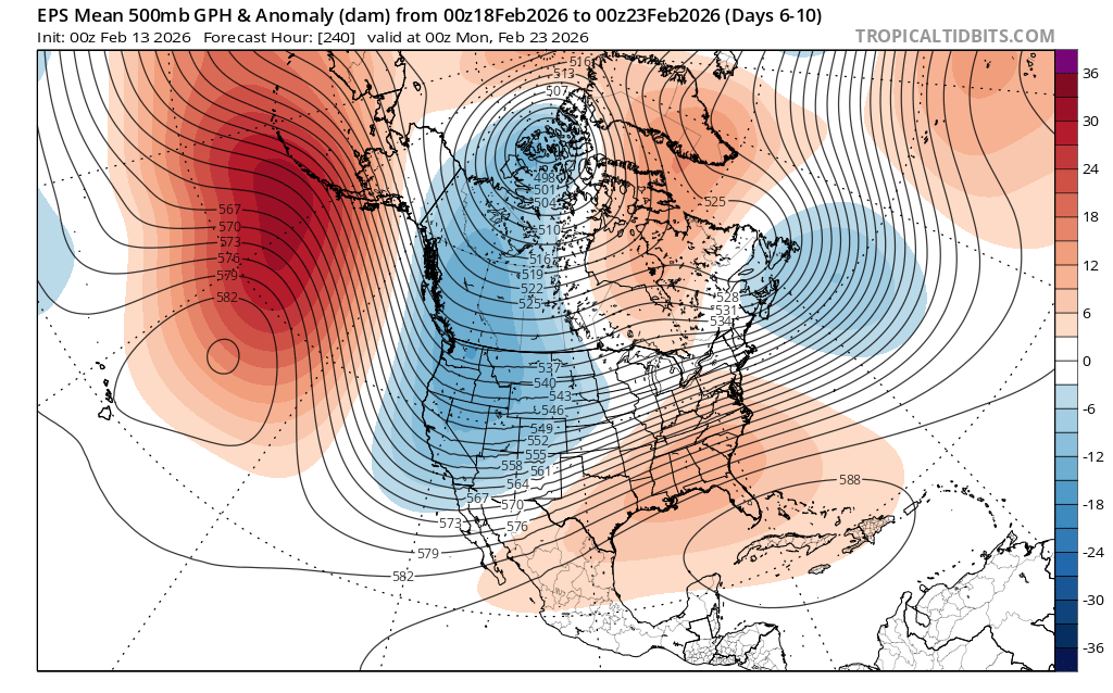
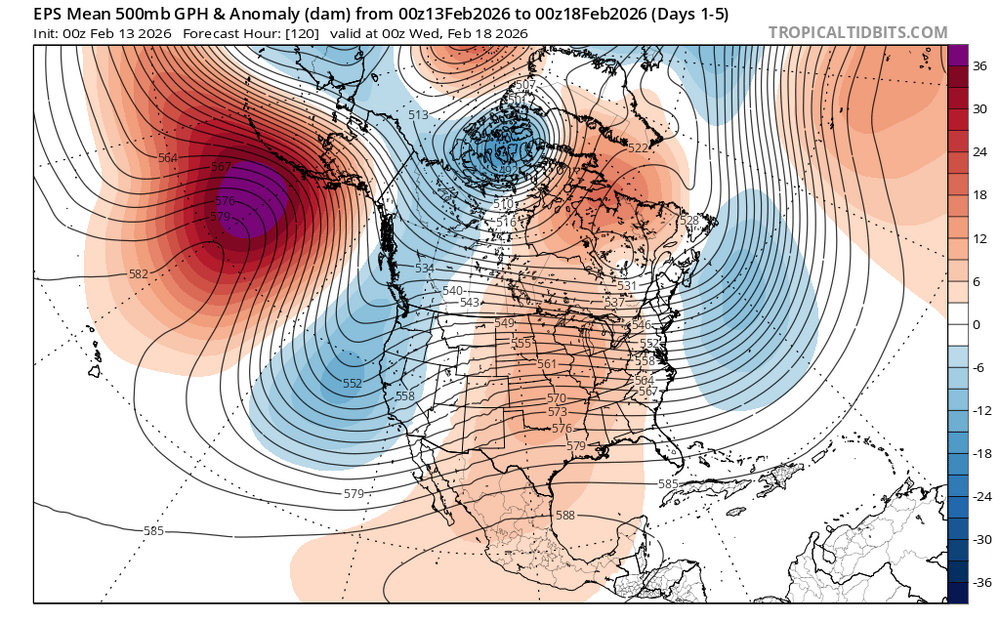
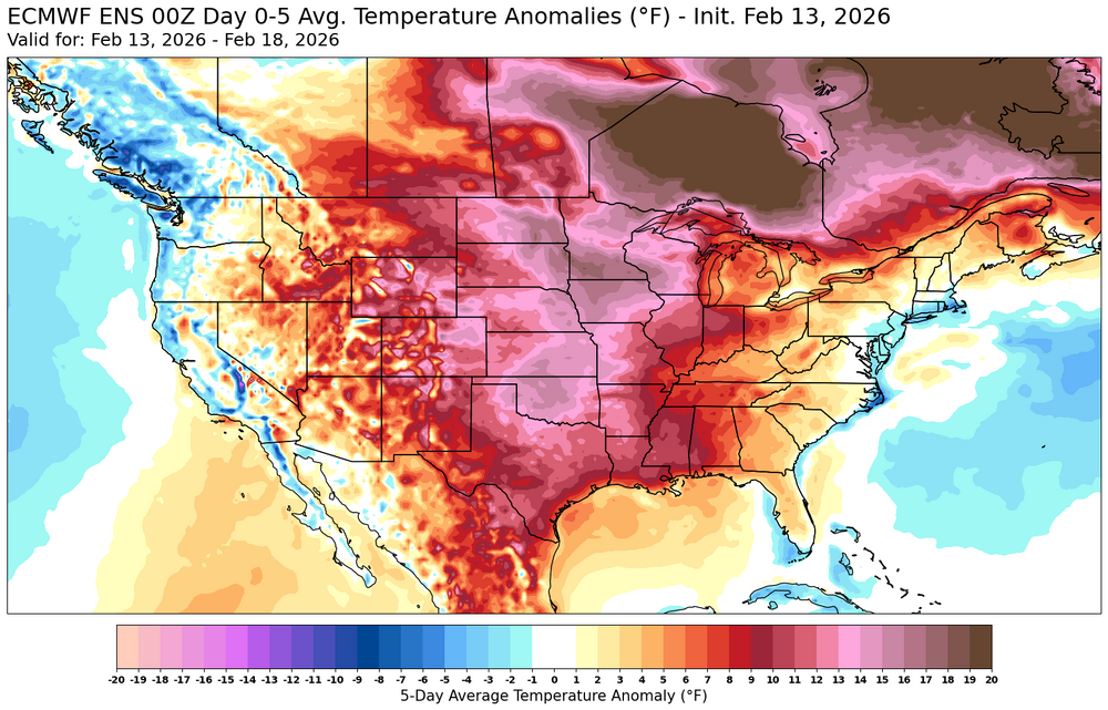
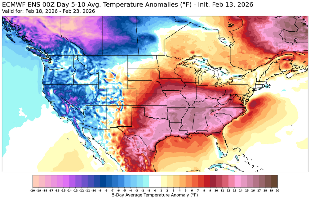
Definitely a more traditional Nina-like pattern coming up for the rest of February. But it’s really interesting that we see a piece of the cooler Northeast relative to other areas which has been in place since November continuing. So more of a close to average temperature pattern here with the warmest temperatures missing our area. Longer term the models are forecasting a transition to El Nino. Nina to Nino summer transitions typically haven’t been very warm here like we saw during years like 2023, 2009, 1997 and 1986. But the last strong drought La Nina to El Nino in 2002 was very warm. That year was a much warmer winter than we just had. So we can see competing influences this year with extreme drought across much of the CONUS and a lingering cold pool near the Northeast. It will be interesting to see if the Northeast can hold onto the local cooler readings relative to other areas or the drought feedback ridge to our west eventually builds into the Northeast with the heat.

-
 Jebman has been brainwashed by Chuck?
 -

Central PA Winter 25/26 Discussion and Obs
pawatch replied to MAG5035's topic in Upstate New York/Pennsylvania
9 degrees this morning. Model's sure don’t have a handle on the weekend storm.


.thumb.png.4150b06c63a21f61052e47a612bf1818.png)