All Activity
- Past hour
-

Spooky Season (October Disco Thread)
512high replied to Prismshine Productions's topic in New England
28F first frost a lot of frosty roofs and windshields this am! -

Spooky Season (October Disco Thread)
kdxken replied to Prismshine Productions's topic in New England
29° first Frost.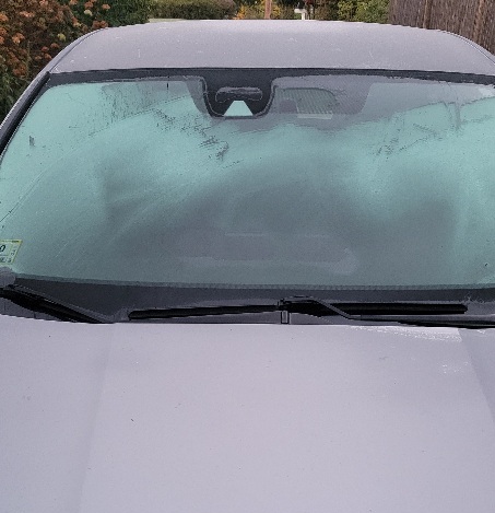
-
52F in Queens. 17 mile drive, +14 degrees. haha
-
 Yea, I hear ya. A good place to check real time tide guages and overlay them against predicted tides is on the USGS sites. Every location, obviously will be different based on fetch, stage of tide, orientation, etc... But, ill tell ya this... water levels in the bsck of barnegat bay are actually running slightly lower right now. Im actually getting ready to head out on the water fir work now. Until late last night, we hadn't yet had any easterly flow since the previous NE blow. Infact, we has northwesterlies. Nevertheless, spring tides only generally exacerbate the tidal flooding 10-15 percent. That 10-15 percent can make all the difference in the world though with a long duration easterly blow, especially with a strong or stalled system inside of the benchmark. Hoping we get more of a scraper, as im not necessarily enthusiastic about working vessel salvages 24/7 during and after the storm. Still approximately 60-70 percent of vessels are in the water for the fall run/locals summer. Towards the end of the season, bilge pumps and batteries on ignored vessels are often not working. Hope you have a nice day. At least we have something local and interesting to track. Ill post many pictures as the storm unfolds.
 -
 Models backed off big time on this. Gonna be a long winter with these inconsistent model runs
 -
It was likely the combination of thick fresh snow cover and strong radiational cooling that produced the subzero November temperatures in 1938.
-
10-22-40 was the earliest single digits that I could find for the old Sussex COOP. There used to be a station at Layton in the Delaware water gap not far from the current Walpack station with had their first single digits on 10-28-36. The earliest below 0° reading for Layton and other surrounding sites was 11-26-38. NJ SUSSEX 1 NW COOP 1940-10-22 49 7 28.0 -21.1 Data for October 28, 1936 through October 28, 1936 Click column heading to sort ascending, click again to sort descending. NJ LAYTON 3 NW COOP 9 Data for November 26, 1938 through November 26, 1938 Click column heading to sort ascending, click again to sort descending. RUNYON COOP -7 CANOE BROOK COOP -5 LAYTON 3 NW COOP -5 CHARLOTTEBURG RESERVOIR COOP -1 INDIAN MILLS 2 W COOP 0 HIGHTSTOWN 2 W COOP 0 BELVIDERE COOP 1 Belvidere Area ThreadEx 1 FLEMINGTON 5 NNW COOP 2 PEMBERTON COOP 4 LONG VALLEY COOP 4 SOMERVILLE 4 NW COOP 5
-

Spooky Season (October Disco Thread)
CT Valley Snowman replied to Prismshine Productions's topic in New England
28 -

Spooky Season (October Disco Thread)
powderfreak replied to Prismshine Productions's topic in New England
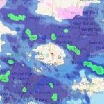
Widespread freeze. ORH at 40F while all around is in the 20s lol.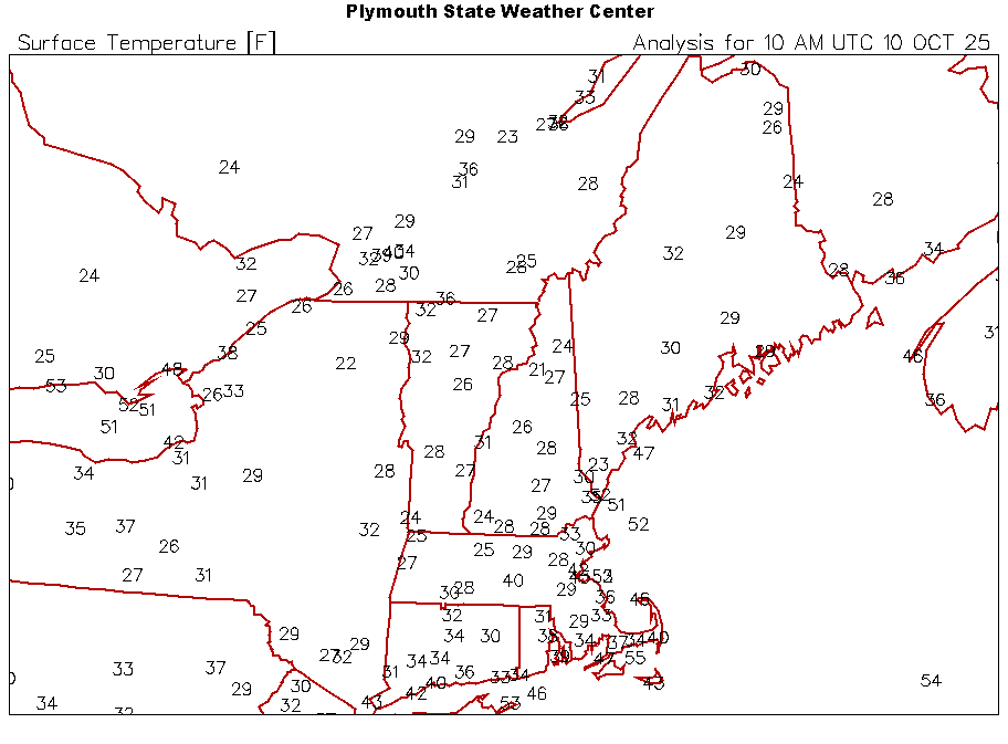
-
35° in Westchester-might-as-well-be-CT
-

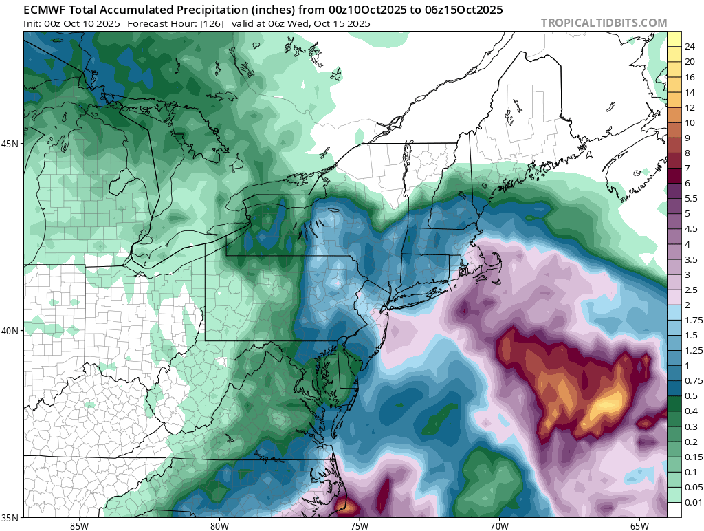
The return of the elusive Nor'easter. Drought buster or bust?
TSSN+ replied to dailylurker's topic in Mid Atlantic
Only if you are a sucker to believe models beyond 48-60hr range. -

2025-2026 Fall/Winter Mountain Thread
Buckethead replied to Buckethead's topic in Southeastern States
35 this morning in Wolf. Sent from my SM-S908U using Tapatalk -

Spooky Season (October Disco Thread)
moneypitmike replied to Prismshine Productions's topic in New England
Save those +30 departures for Christmas Eve. -
Down to 33. Can Mesonet get to 32?
-
35
-
49 here
-

The return of the elusive Nor'easter. Drought buster or bust?
WxUSAF replied to dailylurker's topic in Mid Atlantic
There’s sort of two parts to this. The first is tomorrows afternoon into early Sunday with a deformation axis between the developing coastal and the northern stream shortwave. That seems fairly uniform on guidance? Then the second part is rain from the coastal. That still is uncertain and overnight runs definitely lowered the odds of the big 1”+ amounts. -

Spooky Season (October Disco Thread)
HoarfrostHubb replied to Prismshine Productions's topic in New England
29.2F here A lot of 27 and 28 in my immediate area. -
I caved, flipped the heat on just now, it was 59 downstairs. 29 degrees and still dropping, can I get to 28...
-

The return of the elusive Nor'easter. Drought buster or bust?
snowfan replied to dailylurker's topic in Mid Atlantic
6z NAM is comical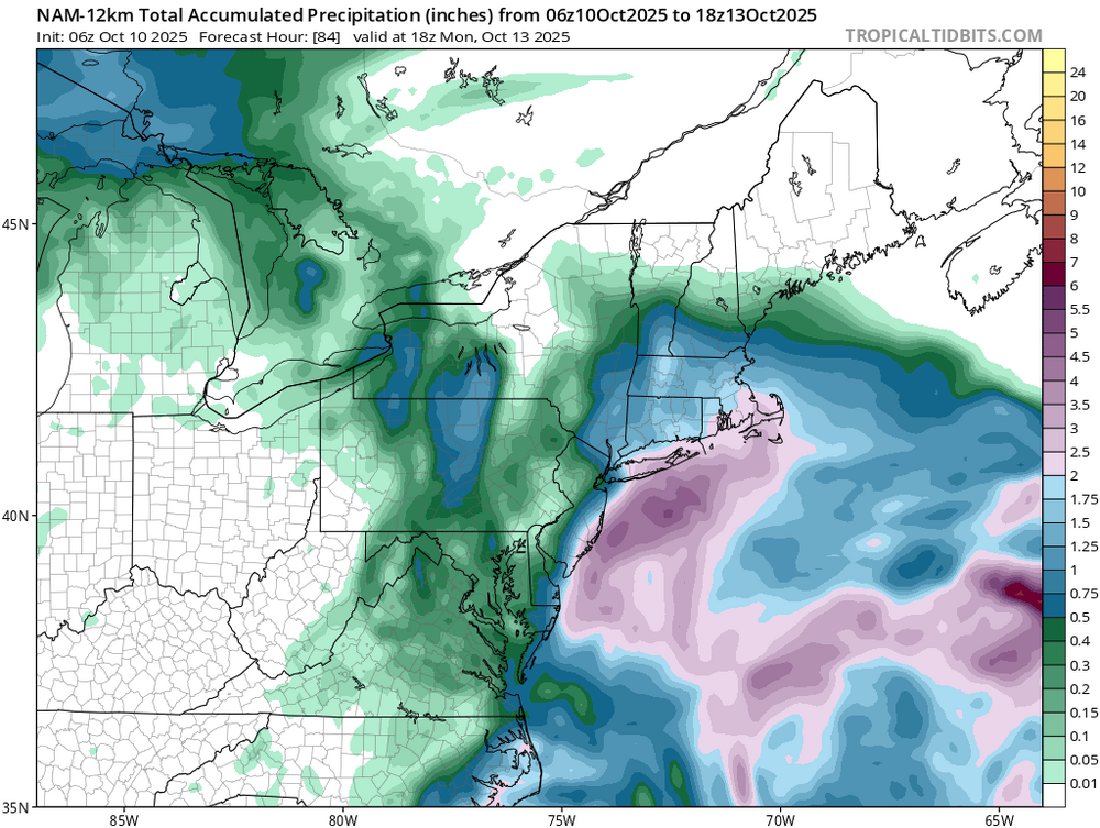
-
Yes, 29 here, just down the road from there currently. KMGJ is a good radiation spot.
-
37F in Hastings.
-
The return of the elusive Nor'easter. Drought buster or bust?
snowfan replied to dailylurker's topic in Mid Atlantic
Oh the heartache if this were winter.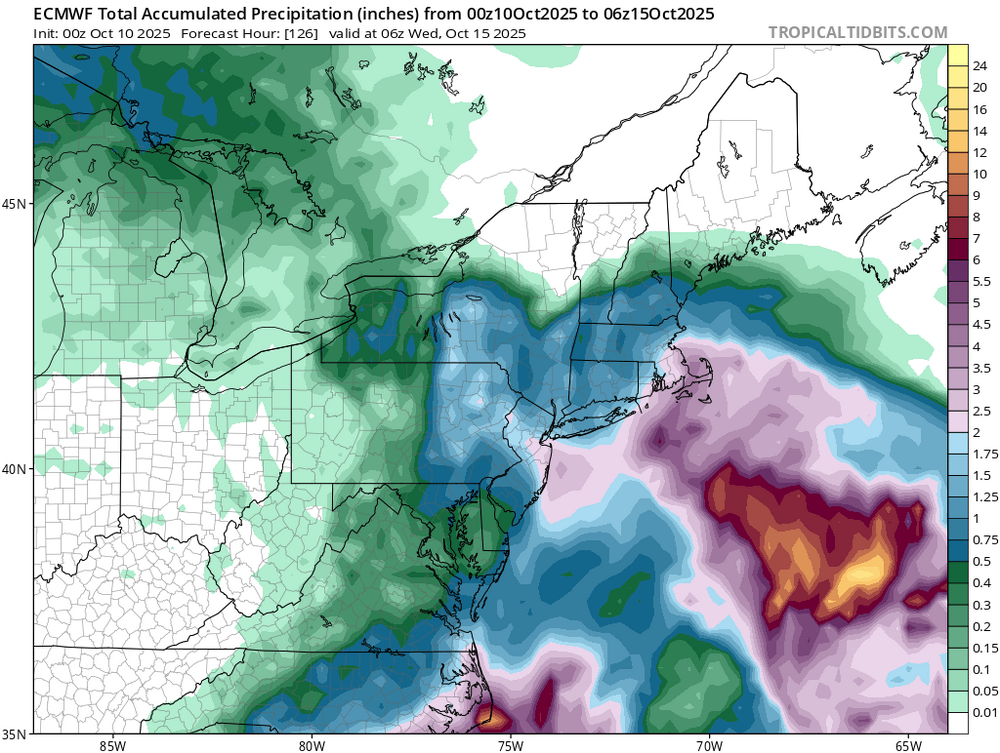
-

Spooky Season (October Disco Thread)
Sugarloaf1989 replied to Prismshine Productions's topic in New England
30F here just before dawn. Went straight past first frost to sub freezing. - Today
-
last 2 nights did not get as cold in the city as was predicted..