All Activity
- Past hour
-

E PA/NJ/DE Autumn 2025 Obs/Discussion
MGorse replied to PhiEaglesfan712's topic in Philadelphia Region
Bottomed out at 33.2F just before 6 AM. Observed some frost. -
28. Had to scrape the windshield this morning for the first time.
-
Some brief windows for snowmaking after the rain end of the week, but not consistent. If the mid month mild up happens then its looking a lot like year for the Thanksgiving weekend faithful. I'm sure killington and sunday river will find a way to get open at least the weekend before while everyone else is scrambling!
-
He is banking on a weak PV just like other forecasters. It should be interesting to see if we actually go into a neutral state or a stronger LA Nina.
-
It’s coming near the tail end of a -NAO period which began around the 15th. Not really sure how to define a classic -NAO since there have been many versions over the years with blocking near Greenland. It’s just that during the 2020s we are finding more ways for higher latitude blocking to merge with the subtropical ridge especially at storm time.
-
It’s actually wobbling south of due west again. What an impactful forecast where we don’t even know when the turn of a cat 5 will happen that will determine the literal fate of some towns on the south coast
-
 Last winter was mid at best. Actually felt like a normal winter.
 -
Yeah, I think a landfall somewhere between Savanna La Mar and Black River. The island is narrower the further West it gets, which could help it maintain intensity/structure as it crosses, upping the potential impact to Cuba
-
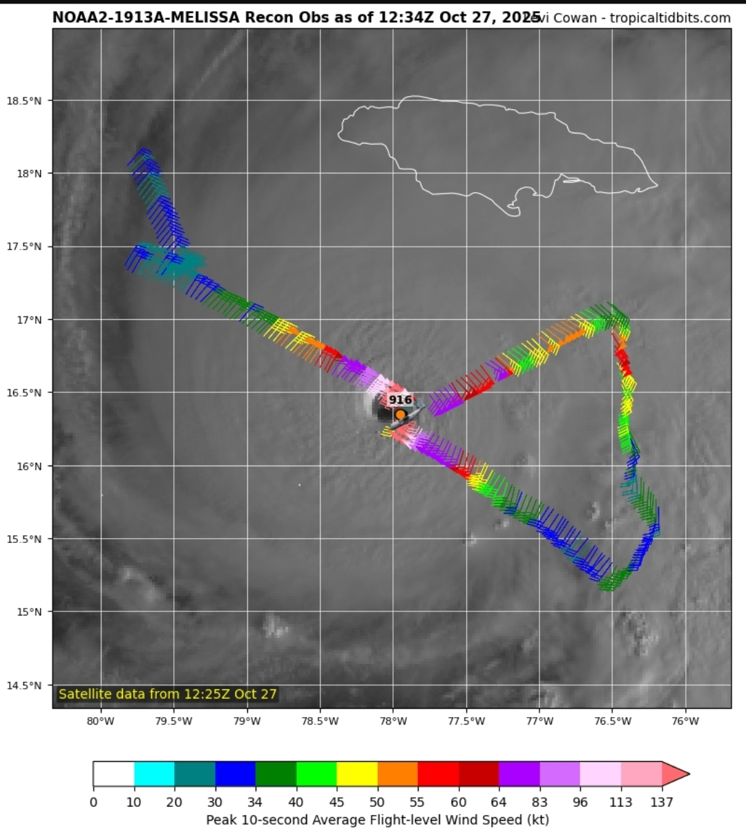
The reason I thought they were missing the NE eyewall a few posts ago is due to this. It appears they flew through the more eastern eyewall than the NE quadrant and might have even missed the center of the eye here. But then I had to remind myself of that pesky parallax positoning of the satellite image.
-
not to be too finicky but that new run is not really a classic -nao to begin with. more of a “newfoundland block.” a true bootleg -nao like we’ve seen in recent winters would be the traditional +gph anomalies extending from greenland through the eastern seaboard
-
The only one I could find that made a sharp turn was Mitch, didn't seem to significantly weaken when making the turn, but did weaken gradually not too long after. Matthew maintained Cat 4 strength well after the turn, but did weaken slightly
-
She’s already passing 78 W. I think the western part of the island and places like Montego Bay could have issues. Basically 12z guidance turns it N now, but I don’t see signs of that quite yet.
-
33° First Frost
-
910 extrap
-
It's moving so slow that it may not matter-if it were moving at 10mph and suddenly lurched north then I can see what you're saying...
-

Spooky Season (October Disco Thread)
Damage In Tolland replied to Prismshine Productions's topic in New England
34.8 here . Grow on -
Recon may be positioning to make an east to west pass. I say that because their current flight path would miss the eye unless they turn due west. Nevermind. I don't know what I was looking at there. It is still a NE to SW pass.
-
Have we ever seen a cat 5 hurricane make a massive change in direction while maintaining strength?
-
It just depends on forward motion, it isn't basin specific. When Melissa starts moving NE, the strong side will be the SE side.
-
If an ERC happens soon, it could mean much worse impacts over bigger areas. Right now the storm is really small. If it turned north right now, eastern Jamaica wouldn't even get hurricane force winds and surge would be minimal outside of the small core.

-

Was Winter 2024-2025 one of the Coldest Winters on Record for BWI
IronTy replied to MDScienceTeacher's topic in Mid Atlantic
It's been so long since we had a cold winter that even an average winter feels like an ice age. -
I am using the term early season to describe the activity prior to what is considered the late August into early September traditional peak we used to get more often. Erin went Cat 5 on August 16th which is early in the season for Cat 5 development. The record SSTs are why we haven’t had any really low ACE seasons since 2013 and 2014. This lead some to speculate that the AMO was going to shift colder back then. But instead the Atlantic SSTs reached all warmth over the last decade with the historic run of Cat 4-5 systems.
-

Central PA Fall Discussions and Obs
mahantango#1 replied to ChescoWx's topic in Upstate New York/Pennsylvania
LONG TERM /WEDNESDAY THROUGH SUNDAY/... Confidence continues to increase in a widespread, soaking rainfall from late Wednesday through Thursday. Surface low pressure will track northward into Pennsylvania as its parent upper trough interacts with an upper low to our northeast, pulling a plume of moisture into Pennsylvania from the Atlantic. The trough becomes negatively tilted as it approaches the region, which should center the strongest synoptic scale forcing right over Central PA Wednesday night into Thursday morning. NBM QPF ranges from right around an inch over northwestern PA, to an inch and a half for areas east of I-99 and south of I-80. It is worth noting that there are still quite a few ensemble members that suggest portions of south-central PA could see upwards of 2 inches of rain. WPC has expanded the marginal risk of excessive rainfall to include all of Central Pennsylvania, but with the drier than normal conditions over the past few weeks, the rainfall should largely be beneficial. In addition to the rainfall, winds will be gusty on Thursday with a fairly tight pressure gradient around the low. Winds gusts of 20 to 30 mph are expected, with some gusts to 35 mph possible in the higher terrain of the Alleghenies. While there are still some timing differences in the models, expect rainfall to gradually taper off late Thursday into early Friday as the low begins to move off to the north. Lake effect and upslope rain showers will continue through the weekend as upper troughing remains in place over the northeastern United States. High temperatures through the weekend will remain near to slightly below normal, generally ranging from the upper 40s to the mid to upper 50s. Lows will be in the 30s and 40s. -

Was Winter 2024-2025 one of the Coldest Winters on Record for BWI
bncho replied to MDScienceTeacher's topic in Mid Atlantic
Was Winter 2024-2025 one of the Coldest Winters on Record for BWI? fuck no -

2025-2026 ENSO
PhiEaglesfan712 replied to 40/70 Benchmark's topic in Weather Forecasting and Discussion
We didn't get the early start to the season this year. The season was quiet until mid August this year, and was pretty much a one-off (with Erin) until Gabrielle.