All Activity
- Past hour
-
Agreed. I was very skeptical of the Euro and GFS going for three days in the 100s. We've seen that fantasy mid range heat vanish before. Not this time!
-
 Man you are balls deep and all in. The lines are drawn!
 -
Definitely has been a quick development of cumulus clouds along the mts down here in the past 30 mins..
-
ATTN...WFO...AKQ...LWX...RNK...PBZ...RLX... LAT...LON 37548059 38018032 39057934 39427883 39597832 39647744 39547686 39357649 38907637 38057671 37237763 36667909 36688013 37028055 37548059 MOST PROBABLE PEAK WIND GUST...65-80 MPH MOST PROBABLE PEAK HAIL SIZE...UP TO 1.25 IN https://www.spc.noaa.gov/products/md/md1491.html
-

E PA/NJ/DE Summer 2026 Obs/Discussion
Birds~69 replied to PhiEaglesfan712's topic in Philadelphia Region
DPs have been lower each day since the beginning of our 100+ days. Today in the 60s...
-
 Since when has the NYC area become the Disneyland for exciting weather lately?
 -
I would assume we would
-
 Can’t wait for you to get 4” and then post because it didn’t soak in well
 -
3 days in a row... impressive
-
Luck ran out. 7-10’d. A few sprinkles.
-
It seems like a lot of folks are thinking 2-3 and higher amounts will be common. Would be great if correct. I won’t buy it until we see how things look early morning Monday
-
Hit 100 finally but it’s an hour behind yesterday.
-

2026 Mid-Atlantic Severe Storm General Discussion
George BM replied to Kmlwx's topic in Mid Atlantic
Wonder if we get an 18z sounding from LWX today. -

Central PA Summer 2026 Discussion/Obs Thread
Itstrainingtime replied to Voyager's topic in Upstate New York/Pennsylvania
96 at 1pm. -
I'm going to be honest the ecosystem is more important than anyone's fourth of july plans lol
-
 Face down in Center Harbor.
 -
His Davis mysteriously going offline this week.
-
good god that's beautiful to see
-
No it’s still out and Potomac Edison’s automated line says it will be out until 3:30.
-
 ICON has like a foot for NYC, ha.
 -
Scooter is really good at sniffing these out and which ones are legit vs BS, which narrow zones might be favored etc. Dude has close to a million posts and the day we need him he’s laying at the bottom of Winni
-
I’d feel fairly confident in 1”+ for your location… but yeah, I guess like winter if folks are looking for jackpots those will be narrow. Someone gets 1.5”, they’ll say they were Steined because somewhere else saw 4.5” and flash flooding.
-

2026 Mid-Atlantic Severe Storm General Discussion
SolidIcewx replied to Kmlwx's topic in Mid Atlantic
Mesoscale Discussion 1491 NWS Storm Prediction Center Norman OK 1149 AM CDT Sat Jul 04 2026 Areas affected...Much of Virginia...Maryland...and eastern West Virginia, Concerning...Severe potential...Severe Thunderstorm Watch likely Valid 041649Z - 041915Z Probability of Watch Issuance...95 percent SUMMARY...Thunderstorms will increase in coverage and intensity while developing eastward through the afternoon. The primary concern will be scattered to numerous damaging wind gusts. A Severe Thunderstorm Watch is likely. DISCUSSION...Widely scattered thunderstorms are evolving along the high terrain in WV and southwestern VA this afternoon. Continued diurnal heating and orographic lift will favor increasing thunderstorm development over the next few hours. Downstream, strong diurnal heating/destabilization of a moist air mass (upper 60s to lower 70s dewpoints) beneath steep midlevel lapse rates (sampled by 12Z soundings) will support thunderstorm intensification through the afternoon. While fairly weak deep-layer shear may limit overall thunderstorm organization, the aforementioned environment will favor a mix of cells and loosely organized clusters capable of producing scattered to numerous damaging wind gusts across much of VA and eventually into MD. A Severe Thunderstorm Watch is likely for this activity. -
For regional 1-3+ synoptic rains.. I mean yes.. lol
-
(002).thumb.png.6e3d9d46bca5fe41aab7a74871dd8af8.png)
Central PA Summer 2026 Discussion/Obs Thread
ChescoWx replied to Voyager's topic in Upstate New York/Pennsylvania
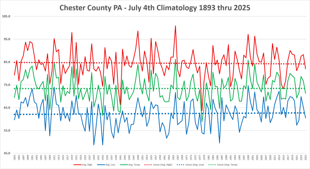
Happy 4th of July to all of you! Below is the history of July 4th weather since 1893 here in Chester County PA. Overall we have seen a flat trend in average temperature / a slight cooling trend for high temperatures and a slight warming trend for overnight low temperatures for the holiday. The hottest July 4th was back in 1966 the chilliest was in 1978.