All Activity
- Past hour
-
That cell turned out to be wicked, turned into Quarter size hail. Lots of leaves down and a gust to 47 mph. Luckily it has moved North now and seems as if the vehicles didn’t get any damage.
-
Tornado warning just NE of Richmond.
-
Looks like another sneaky severe evening.
-
Congrats Freak and Dendy and Dryslot
-
Plenty of time to trend north which seems likely
-
Perfect track Fri/Sat for SNE. I don’t want to hear any bitching come winter now.
-
Had a decent downpour that got us to 0.15" for the day here. 0.55" for the event so far, which is pretty disappointing. Hopefully we'll get lucky with a t-storm tomorrow afternoon. If not, the advertised big soaking 4 day period is going end up a big disappointment. Definitely a big bust for the Euro model which showed ridiculously high amounts for days.
-
.71 so far. Radar looks anemic for now We’ll see how the 3-6” forecasts here some had and flood watches work out . Time will tell
-
1.2” today, 3” MTD
-
Just got warned BULLETIN - IMMEDIATE BROADCAST REQUESTED Severe Thunderstorm Warning National Weather Service Baltimore MD/Washington DC 617 PM EDT Mon May 5 2025 The National Weather Service in Sterling Virginia has issued a * Severe Thunderstorm Warning for... Northwestern Stafford County in northern Virginia... Southeastern Fauquier County in northern Virginia... Southern Prince William County in northern Virginia... * Until 645 PM EDT. * At 616 PM EDT, a severe thunderstorm was located 7 miles west of Stafford, moving north at 15 mph. HAZARD...Quarter size hail. SOURCE...A trained weather spotter observed quarter size hail in Glendie. IMPACT...Some hail damage to agriculture is expected. * Locations impacted include... Heflin, Ruby, Somerville, and Roseville. PRECAUTIONARY/PREPAREDNESS ACTIONS... For your protection move to an interior room on the lowest floor of a building. && LAT...LON 3841 7748 3840 7756 3854 7767 3858 7751 TIME...MOT...LOC 2216Z 158DEG 15KT 3842 7754 HAIL THREAT...OBSERVED MAX HAIL SIZE...1.00 IN WIND THREAT...RADAR INDICATED MAX WIND GUST...<50 MPH
- 476 replies
-
- 1
-

-
- severe
- thunderstorms
- (and 2 more)
-
I picked up a bunch of veggie plants today and was going to put them in this evening, but I’ll wait a day and keep them safe under the patio table. In other words, I’m jinxing myself out of any thunderstorms tonight.
-
Looking at RadarScope again I think it’ll scoot to my west, but I’ve heard rumbles in the distance, so who knows.
-
CT should be ok by Sat late morning but AEMATT may have a wettie
-
Storm total here now .92
-

2025 Lawns & Gardens Thread. Making Lawns Great Again
Brewbeer replied to Damage In Tolland's topic in New England
mine's getting long and it's only Cinco de Mayo ! -
Just reported Nickel size hail in the cell that popped up basically over my house in Stafford, near Hartwood, VA.
- 476 replies
-
- 3
-
-
- severe
- thunderstorms
- (and 2 more)
-

E PA/NJ/DE Spring 2025 Obs/Discussion
ChescoWx replied to PhiEaglesfan712's topic in Philadelphia Region
0.23" of rain since this morning here in East Nantmeal this brings our 3 day total up to 1.51" of rain. -
@aldie 22 gonna get recked
-
Yeah I saw that. Told my kid that it would slip to the N. Just got put under a warning for it by a sliver.
-
.thumb.jpg.6a4895b2a43f87359e4e7d04a6fa0d14.jpg)
Central PA Spring 2025
Yardstickgozinya replied to canderson's topic in Upstate New York/Pennsylvania
I also love my mistakes corrected in a civil manner. Be a dick get a dick has always been my philosophy. -
It's actually getting weird...the cell by Brunswick is heading ne while almost every storm has gone nw. This area has been a storm magnet today.
-
You will take your watch and like it good sir
-
2-3' on the GFS end of the week into Saturday. Deformation and ratios TBD.
-
- 476 replies
-
- 1
-

-
- severe
- thunderstorms
- (and 2 more)
-
Central PA Spring 2025
Yardstickgozinya replied to canderson's topic in Upstate New York/Pennsylvania
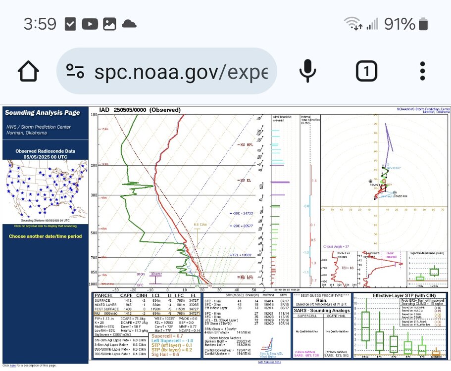
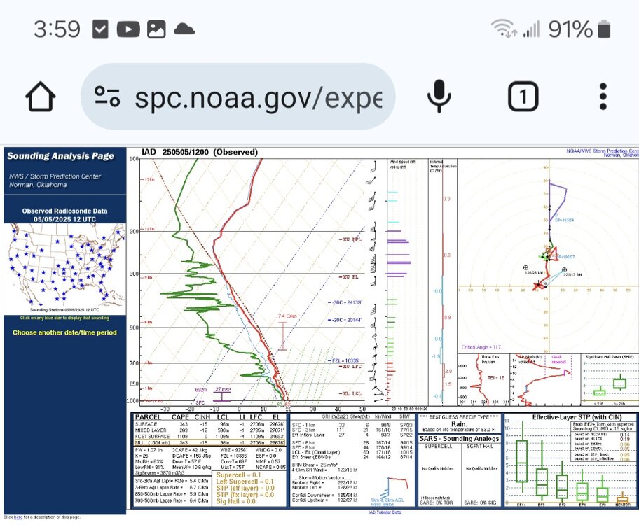
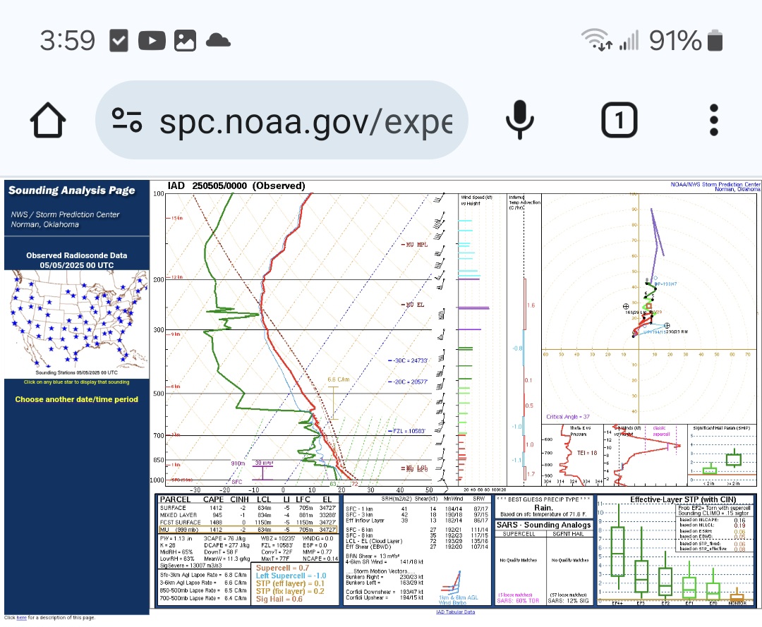
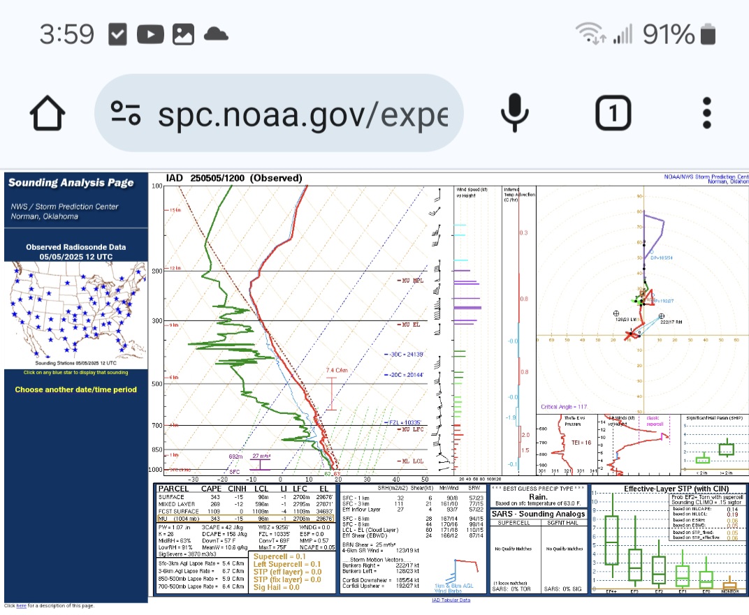
Once again, I'm not claiming to be anything close to Ace, but I enjoy pretending, lol. To my amateur eye, IAD just needed a little more veering to the north in the mid to upper levels and a little cooling above 250mb, and IAD would have had some sig hail issues today . Unfortunately, the latest sounding for IAD has lost most of its juju and really narrowed the cape field down to a sliver. Im assuming the warming above 225mb and those little inversions from about 675mb down to 950mb are a marine layer and to blame . I realize we are not in Baltimore, but it's the closest observed sounding I know of to practice with. I'm not ruling out any thunderstorms or rain this evening just pointing out something I noticed at IAD.